A journal of canoe expeditions along the rivers of Australia's Murray Darling Basin using photographs, stories and information to highlight the beauty, challenges and history of these rivers and the communities they flow through.
Day 31: Wellington, view from our balcony at the old Wellington Hotel. The evening before the lake crossing, with Jack's Boat in the foreground.
Day 31: Dawn in Wellington. By the time this photo was taken, I had already been on the water for 2 hours and was well away from the shoreline. I could now start to use my compass and maps and was less reliant on my iPhone 'radar'.
Starting off at 4:30am there was no moon, I had to be very careful where everything was and that I would be able to find my way. The beginning was a little deceptive because the strong lights from the ferry at Wellington lit up the whole river. Once past the island of light around the ferry, I paddled into increasing darkness. I had given up the idea of a torch. The river was too wide and it would ruin my night vision. I paddled gingerly into the void, trying to make out where the banks of the river began and which direction the river was headed. One way to make it out was the absence of stars. The sky was full of them. The milky way stretched high across the heavens and the Southern Cross was clearly visible, indicating South. On my deck and tied to the net in front of my cockpit I had my favorite old bushwalking compass. Don’t let me down, old friend. Next to it in its own waterproof bag was my new friend, the one which has made all these reports and photo uploads possible - my iPhone. In addition to this, in its own waterproof map case, I had a small copy of a map of the lake to which I had added the bearings that I would need to take to get to stages of the journey across the lake and the approximate distances. In the same map case, I had a copy of the Murray River Pilot, which gave more detail on beacons, bearings and dangers.
Day 31: Pelicans have been my companions on the Murray since before Mildura. Whilst crossing the lake they often circled low overhead, curious I suppose, but it was nice to think they were kindred spirits.
It was so dark that the maps were useless for the first 13km. It took the one and a half hours I needed to get to the open lake to be able to see them. Up until this time I had to rely on the Maps App from my iPhone. This was brilliant. That CEO should not have resigned! I was able to get a satellite image of where I was, see which direction I was headed and how close to the banks I was. It was close as a sea kayak ever had to having a radar screen. I remember the times I spent on the Nella Dan in the Antarctic. I used to like spending time with the Captain, or mate up in the bridge when I could not sleep and would watch the radar screen which was used to keep a constant lookout for icebergs. The maps app gave a similar sense of security. I used it to navigate safely out into the lake and then used sight and compass bearings from there as my main tools. The maps app was still useful on the open lake however, because it gave me an absolute fix on my position. When navigating it is important to compare where you think you are and where you actually are. This is why the sea captains in the days of sailing ships had to have such accurate clocks and to be able to work with theodolites. The maps app filled this spot for me.
We had heard tales from the old fishermen in the pub about how wild the lake can be. One gentleman with a long grey beard, bad teeth and a firm hand grip said that you have to hope that you have been treating the lady right, because she’ll turn and throw anything at you that she wants. it can be as calm as day everywhere else and she will throw in a storm. Another said that because it is so shallow, only a couple of meters deep the waves whip up quickly. He can remember being out their in a tinny with three other blokes and a storm blew in. The waves were 6 feet and only 6 feet apart. In every trough the outboard motor hit the ground and with every wave water entered the boat. It was so rough, they all had to sit on the bottom of the boat, and all three who weren’t driving bailed the incoming water. “ok”, he said, “the waves were not quite that bad, but it felt like it. “it’s called the Coorong Doctor”, said Heather, one of the party headed for Goolwa the next day, “the Coorong and Lake Alexandrina have their own weather.”
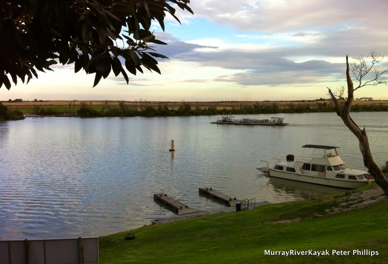
Day 31: Dawn, on Lake Alexandrina.
I headed out into open water. Despite the gentle breeze, there was quite a chop up. I had assured everyone that I would take the coastal route. The fishermen suggested I curve towards the coast but not deviate too far from the passage. I decided to give it a go. After all, Jack’s Boat was also coming this way and would be keeping an eye out for me. I found the first (and it turned out, the last) navigation beacon, set my bearing for Sturt’s Point 26 kilometres away and set off. If I was to have difficulty I could always head South to the coast. The chop became waves which hit me from the right and rear. In addition to the waves being driven by the wind, a second set seemed to exist from the weather that had passed through previously. This bounced the boat around and turned it, either into, or away from the waves, depending on their pattern. Yet the boat kept its course and momentum. I went further and further. At one point I hazarded a look to my left towards the coast, 4 kilometres away. Rolling waves, one after the other raced towards the coast. The sun reflecting off their backs had a different colour, a greyer shade , than the rest of the lake. It was quite unnerving. I knew the same was coming from the 20 kilometres of lake on my left. I told myself, keep calm. People travel around Australia on ocean voyages. If you can handle 5 minutes, you can handle 5 hours. Just keep going, keep calm and keep safe. Every half an hour I rewarded myself with something to nibble on, a 20 second stop and a navigation check with the iPhone. I had my compass on my deck and constantly followed my bearing. This was necessary every wave, because every wave changed my direction. After two hours the land I was headed for became visible. In another hour I was there. Sturt’s point in four and a half hours, with an average speed of eight kilometers an hour. I tell you what though, I am glad all that chop was a tail wind. Did you know that people also swim the Murray... and the lake. How tough would that be?!
Day 31: The Murray, coming into Goolwa.
Day 31: Something comforting and humorous about arriving in civilisation after crossing the lake. There was the most wonderful and friendly yacht club here. The members opened the facilities for us here and told us of all the ways one could get to the mouth. The swimmers always take Mundoo Channel they said. Swimmers! Tough cookies!
Day 31: Clayton Bay, neighbour to Goolwa. Now the Murray has a distinctive marine atmosphere.
Day 31: Arriving in Goolwa.
Day 31: Pulling into my final campsite. My boat has been a good friend. Nothing at all went wrong, there was plenty of room for everything... and it behaved as if it was in its element in Lake Alexandrina. Now it gets a clean and rest.
Day 31: Coming into Goolwa, into the caravan park where we are staying.
The Murray is more of an estuary here than a river. It is very wide.
Day 31: Honouring the river. I now understand that the river does not naturally have a mouth, but rather a series of entrances to the sea. The Coorong is its interchange. Except in times of flood, there is no natural estuary. We have tried to change this with the barrages which join the islands that border Lake Alexandrina, keeping salt water from fresh. The Coorong is the Murray's inland estuary. When the river stopped flowing at this end for much of the last 10 years the Lake was a meter lower than the sea and 5 times as salty. For the sake of the Coorong it would have been better to allow the sea in. I think the idea is to use Alexandrina as a fresh water reserve however. Must find out more about this.
Homeward journey.
I reached the best possible goal I had set that morning, to arrive in Clayton Bay by evening, at 11:30. I had contacted Ruth and Anna and we met for lunch at the yacht club. Whilst there we met Hal and Lucy who had travelled from Goolwa to Echuca and back earlier this year in their yacht (mast removed) to take part in the hundred year celebration of the PS Melbourne. They congratulated me and shared their own story and love for our river and its history. They told how once they hit a snag and the whole front of their yacht rose up and out of the water, it kept going and the yacht was balanced in the air, until it edged on, slipped off and even cleared the motor. It reminded me of all I have seen, all the stories I have heard, all the experiences I have had and am thankful for the opportunity to have experienced these.
The Murray is so full of stories, so full of life, so dynamic. It is waiting to be discovered, again and again, by each in their own way.
Day 30: Look what pulled up in the night! Glad I didn't camp there. The Proud Mary, with very strong spot lights!
Day 30: Sunrise and calm water. Time to make the most of it!
Woodside reserve was a great camping place, so long as you did not camp on the lawn area. As another team of paddlers noticed, to their detriment, the sprinklers come on at 4:30 am. It was a bit of a rude awakening.
Camp here and you will get wet. Sprinklers come on at 4:30am.
To be fair, there is a 'no camping' sign.
Today’s goal was to get to Wellington. This is the last town on the Murray while it is still a river. Four kilometers downstream from Wellington, the river opens up into Lake Alexandrina. As I have mentioned before (I think), this lake is my nemesis - the big test at the end of the paddle. Unaccompanied paddlers usually go around the lake, which is longer, but safer. If you can get someone to paddle with you who has experience, or have the company of a boat for the passage, and the weather is good, you can risk the direct crossing. The direct crossing is 26 kilometres across, after 13 kilometres of a widening inlet. This means 39 kilometres of rough water, without the chance for a break. I have been training up to be able to do this distances without risk of injury for some time, but the proof is in the pudding.
I wanted to get to Wellington, because there was a favorable weather forecast for the next day, and also Ruth and Anna were coming down from Echuca to meet me at the Wellington Hotel. We had a bit of a race going, seeing who could get there first.
Day 30: Old homestead on the run into Murray Bridge.
I stopped in Murray Bridge about 9 am after two hours of paddling. Most of the town seemed to be up on the hill, but just before the bridge which gives the town its name there is a very interesting little dockyard / museum. I drifted in, enjoying the ‘mess’ made up of bits and pieces of machinery from the river boat days and all sorts and sizes of boats, in various states of repair. There was a quirky little paddle steamer with an even smaller boat on a derrick above its paddle wheel box. It was so small that only one person could fit in it - and you would have to think carefully about whether you took your shopping along too.
Day 30: The docks at Murray Bridge, boats of all shapes and sizes.
Day 30: Little boat for a small paddle steamer, the Lady Rae.
Day 30: The docks at Murray Bridge, works in progress.
Day 30: Murray Bridge. Bridge. One of the few in South Australia; most river crossings are by ferrie.
A lot of towns along this end of the river have beautiful riverside parks and Murray Bridge was no exception. Immaculate lawns, shady trees, playgrounds, artwork and... the bunyip. The bunyip is an aging automatic monster. Placed in a pond, under a curving corrugated iron roof which looks like a bunker, children are encouraged to place a dollar in the money slot. If you are lucky and the machine is working, a big toothy green monster with big claws comes out of the water and scares the daylights out of the little kids. As if to give their parents a legitimate reason for doing this, there is an information board about what Australia was like when diprotodonts (sort of a giant wombat) were cool kids on the block. I am not sure the information is necessary, I think the parents would do it anyway. I would. :)
Day 30: How I keep in touch, my iPhone and river guide - always on my lap.
When the bridge was built at Murray Bridge there was no other crossing the river on the route between Adelaide and Melbourne. Cattle and sheep were swum across, or had to take turns with people and drays on the punts which are still a feature of the lower Murray. The place chosen for the bridge would have had major economic benefits. The South Australian government of the time decided for this location (a bit like early Canberra, in the wilderness with no infrastructure) over Wellington by one vote because of solid basalt in the river bed. A new town sprung up around the bridge, a railway line and subsequent bridge for it was built as well. Wellington’s trade suffered and it became the sleepy little hollow it is today.
Day 30: Carved stone seat celebrating the creatures of the river. Murray Bridge.
Day 30: Murray Bridge bollards carving project.
I tried to call in on Tailem Bend, but the shorefront was so steep and so canoe unfriendly that this was almost impossible. Eventually I managed to find a spot under an old willow and extracted myself from my kayak with a twisting rolling move, which almost dumped me in the water. Apart from a brilliant view over the Murray from a lookout on top of the cliff, which showed just how large its bends are, it was hardly worth it. Tailem Bend is full of franchise takeaways, car part warehouses and the hungriest flies around. These followed me down the river when I left, constantly trying to get into my eyes. Not a good impression.
Day 30: Last 100!
Day 30: Old ferry landing at Tailem Bend.
Day 30: Tailem Bend. One last big curve before Lake Alexandrina and the sea.
Ruth and Anna beat me to Wellington, but only just. We moved into a unit, prepared for the day and went to the pub to check out local knowledge about the lake and Monday’s schnitzel specials. Here we met Jack, Bill and Heather. They were traveling across the lake the same day I was planning to in their 15m cruiser. A magnificent, but aging vessel, this was to be its last voyage in their hands. It was time to sell. It had never been officially given a name, it was always just Jack’s boat. Jack’s boat was built for the Coorong and they had spent decades exploring it. It was big enough to handle any weather and they had often served as a safety boat in races when smaller boats were going under. We joined tables and had a really good chat. “You have to be on the lake by dawn, not just on the water, on the lake” said Jack, “that is when its calmest”. We swapped phone numbers and they agreed to scoop me out of the water if they hear I am in trouble. There was plenty of room on the back to carry the boat if need be. Having someone look out for me helped me to feel more confident about the next day. They were taking their boat to Goolwa, no longer the sleepy little seaside village from ‘Storm Boy’, it was the best place to sell their boat. Jack said it was worth $300,000 but he would take $175,000. Heather commented that they should take $50,000 if it was offered. It was time to get rid of it.
With a 3:30 get up and 4:30 start, we went to bed before 9 and tried to sleep. I woke after 2 hours and every hour after that, sure it was time to get going. I was that fired up for the next day.
Last night I did not eat well, I made the mistake of having a rest before cooking and then was too tired to do anything but nibble. I woke up well enough, but found that despite a good brekkie had no strength. Not good on a day where headwind turned out to be a feature. Headwind around here means waves - usually big enough to sink a TK2, but sometimes as big as a paddle steamers wash. I experimented with style, rests, etc, but nothing seemed to work, so it was grin and bare it. Even a slow pace will get you where you want to be in the long run.
Day 29: A rare patch of sunshine.
Day 29: Today was a day of headwinds from start to finish. The long straights funnel the wind and I just happened to be unlucky in their direction.
My first break was at Younghusband, an odd name, but also the name of a successful land agency all around Australia. Did the founder come from here? I wonder. At Younghusband there is a small caravan park, which has a small shop, which is where everyone meets, that and the truck load of dirt they have tipped near the river, sandbagged it so that it won't flow away and call it a beach. Even at this place of dubious quality, where the toilets are large concrete pipes with doors in them and you find yourself turning around looking for the thing you came in for. Even in this place, you don't walk into the store dripping wet and wearing a gorges lacked thermal and shorts in summer. Fashion crime! The owner looked me over twice, her eyes traceable as she went from top to bottom, and not believing it, did it again. I walked into her shop so she followed me. No she did not have fresh vegetables, only cans and frozen. I considered for a moment, but decided my ageing veggies were better than anything she had in the shop, but bought a pie, as if to show I was normal under all this garb. I don't know why I bothered, it didn't work, this caravan park diva was queen of all she surveyed - even if it was not much - it was hers and everyone came to her.
Younghusband was not a total loss. I met up with two young blokes who had raced past me in a small tinny earlier in the day and with whom I had stopped to chat, when I caught up with them again. This time they had two friends with them. Despite 4 in the small boat it still managed to plane at considerable speed. The boys had picked up hot chips and were about to head back to their shack, but stopped to chat. They were from Adelaide and just up for the weekend. When I mentioned that I was impressed with the speed of their boat, the owner informed me it was a 12 ft pelican, fibreglass and with a 25 HP motor (twice what it should have) and that it could do 50km/hr. on the back it had two huge beach fishing poles, each adorned with a Murray River flag. To make the boat look bigger and faster, I enquired? A smile came in return - of course. I liked these guys, they epitomise the good fun the river can be. As they left one of them asked, "is this as fast as you're going to go?" The driver cranked it up and they were off.
I cooked up some chicken noodle soup for energy and to get warm. The salts from the soup are good for electrolytes, the noodles are easy to digest and deliver slow release energy and the oils longer term energy. The warmth was good to, as I was soaked through and after a while, even with all the gear on, that cools you down. 30 kilometres done, another 20 to Mannum. Refreshed the headwinds seemed a lot more manageable.
Day 29: Finally a good shot of one of the many ferries that cross the river in SA. It's free, so you can go back and forth as many times as you want!
Day 29: The business end of the Marion.
In Mannum, just after the ferry and the magnificently restored paddle steamer, Marion is a huge park. The park stretched almost from one end of the town to the other, it had zones for paddle steamers, visiting houseboats, swimmers, speed boats and jet skis. It was full of people, locals and visitors alike. As I drifted in looking for a place to stop, a fella, Jeff, offered to give me a hand and suggested I pull in where he was, "there aren't any better places". I hauled me boat up the 1 metre high bank and then began to chat with him. He was reading car magazines and was supervising his grandson. He could keep an eye on the boat. I should visit the pub, the supermarket (we have a supermarket!) and the bakery in his opinion. I showed him my map and asked his opinion on my choice of campsite. Yep, that should be good - though he did keep forgetting what we had just talked about, so that was a mild concern. I took up his offer and strolled first through the park and then through town.
Randall's square boiler. On his first voyage it began to bulge. Randall wrapped bullock chains around the boiler and used wooden wedges to tighten them.
Stuff for sale: Mannum blacksmiths.
There are plenty of original buildings in Mannum. This town has character and charm.
I was so impressed with the park. Amazing what a small town of 3 - 5,000 people can do. It included historical monuments, band stands, room for everyone, and, in the middle of everything, a rowing club. Murray Bridge's rowing team, 'The Cods' represented Australia in the 1924 Olympics in Paris and being a neighbouring town, their would have been local rivalry. Directly behind the park is a row of old houses; all people's homes. Mannum seems to live its history. Walking up the hill to the main street, there are more old homes. Christmas carols are playing from speakers in the streets. The lamp posts are decorated with over sized tinsel and bells. My eye falls on the bakery and I walk in, order a coffee and a 'London Bun' as the girl behind the counter doesn't know what a coffee scroll is, and take in the scene. A couple of motor bike riders, in full leathers, two elderly couples who have just stepped out of a vintage car and a young family. Time is getting on, but I continue along the main street. One of the bikie guys is there. He introduces himself as Don. He used to come here as a kid, as his parents had a shack up the river, and now had just come up from Adelaide for lunch. He said he often comes here to gaze at the river and enjoy the atmosphere in town. Everyone is friendly and it relaxes him. Time to go. It turns out that Jeff is still watching my boat. Almost everyone else has gone from the park.
Jeff used to be a dairy farmer, but all the local dairy farmers got out of the game. Falling milk prices and rising costs made government offers of water buy-backs hard to resist. He lived in Adelaide for a while, to be close to the kids, but came back because he likes the quiet here. Jeff told me to keep my eye out for a new marina development downstream from town. That used to be dairy farms, he said. You've still got a long way to go to the sea you know. I skied it once. Bloody near killed me.
Off again. 2 hours till camp at Woodside Reserve. The winds have dropped and only occasionally cause a bit of trouble. I arrive at camp about 6pm, change into dry clothes and begin to cook up something warm. The reserve seems to be set out for specific groups, but I can't seem to find the sign for canoeists paddling towards the sea, so I camped just the other side of a hedge. It doesn't seem like anyone lives in this town anyway. Perhaps it is all holiday homes, I thought. With this in mind, I cooked and ate under the members only sign on a cry nicely placed table and bench.
Day 29: Campsite at Woodland reserve, downstream from Mannum.
Serenity... Except for that rumble. Out of the dark came the MV Proud Mary. It's spot lights scanning the bank. It pulled up 100m further down. It seems that Woodland Reserve is its home port. I had considered camping just next to their sign too. Glad I didn't. Those spot lights were strong!
Last day of the river tomorrow. Just under 60 kilometres to Wellington... And then we shall look at the lake. Google+ Entire Photo Album