A journal of canoe expeditions along the rivers of Australia's Murray Darling Basin using photographs, stories and information to highlight the beauty, challenges and history of these rivers and the communities they flow through.
Day 28: Goodbye Blanchetown and the last of the Locks (lock 1). The difference in height between the downstream side of lock 1 and Goolwa is only 75 cm. so there will not be much current for the next 300km.
Day 28: Interesting weather ahead.
The forecast for today was ominous, South Westerly winds 15 to 20 km/hr gusting to 40. I am on the section of the Murray which heads South. It has seen the promised land and wants to go to the sea. It does that by heading South - right into the wind. The first straight was 16 kilometres long, longer even than the one leading into Moorook. I decided to get up and leave early, since the winds are usually calmer in the mornings. Not so this morning. I woke at 5 am, tried to get a bit more sleep, but to no avail. A gale was blowing outside. I waited 30 minutes and then began to pack. Luckily, in this time the wind calmed and I was able to begin my day's journey in calm conditions. As heavy clouds were building and the forest predicted rain, I put on my heavy spray deck. As well as keeping out water much better than my summer spray deck (which only covers half the cockpit) it keeps me much warmer. Anything that keeps you warm when wet is welcome.
Day 28: Aussie pride.
Day 28: Windmill against a dark sky. Leaving Blanchetown.
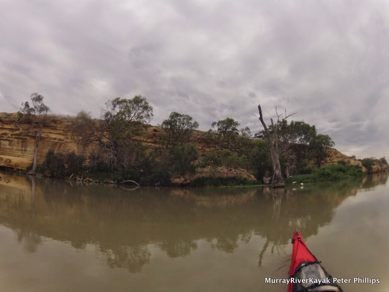
Day 28: River landscape: between Blanchetown and Big Bend.
I passed the point where Eyre made his camp 6 kilometres South of Blanchetown. It looked a nice spot, but a bit of a let down after the adventures of his great exploration. The South Australian government valued his ability to make peace with the aboriginal people, but it must have been lonely there. Perhaps Eyre did not want the city life, but he must have longer for educated conversation and recognition from his peers. Despite investing heavily in an irrigation scheme for the area, Eyre left for England only two years after taking his position at Blanchetown. What happened to him in England I do not know, but geographical societies were all the rage for gentlemen in those days and a man of his experience and good character would have been a sort after discussion partner for those wanting to learn about the colonies.
Day 28: Old irrigation pumps, downstream from Blanchetown.
Day 28: What shacks used to be like. Now they are more like condominiums.
Day 28: What shacks used to be like. Now they are more like condominiums.
Day 28: Big Bend. Between Blanchetown and Walkers Flat.
Day 28: 220km later, the cliffs are still spectacular.
Day 28: Headwinds, my constant companion since the river turned South.
In Swan Reach the river has a bend. Gasp! Finally! The cliffs on either side force it to. Rivers erode the banks on the outside of their bends, because there the force of the current is greater. They deposit sediment on the inside of their bends because the slower water there and edges cause it to drop sand and mud. Over time, the river moves through the space available to it, much like a hundred snake tracks. In the wide sections of the Murray, billabongs can be quite far from the river, as when the river takes a new track it has a lot of choices. Between these cliffs there is not so much room. If we were to watch its action sped up it would look like a writhing snake, trying to get out of its confines, but unable to, hitting one wall and then the next and repeating this over and over again. In Swan Reach, the cliffs are clearly visible on either side of the river, one forming one of its banks and the other a bit further away and every space in between is filled with billabongs. It is a paradise for wildlife to rival Kakadu.
Day 28: General store in Walker's Flat. Community hub, information and great chips!
Old fishing signs: public and commercial.
Day 28: Afternoon light, Murray Cliffs, Walkers Flat.
The villages here have interesting names. Travelling along this section of river I passed through Moorunde, Portee, Kooloola, Punyelroo, Nildottie, Wongulla and Walker's Flat. In Walker's Flat I stopped, tempted by the nice green lawns next to the ferry and the possibility of a treat at the shop. In the shop was a sticker, "Where the bloody hell is Walker's Flat - down the road from Wongulla you idiot". The Walker's Flat shop is a real community hub, where the owner, not only makes it his business to get people to talk together and share their stories, but also has local history on the walls of his shop. He was helpful in pointing out good camping sites and a few to avoid. He also makes very good hot chips :) . A fishermen burst in all excited whilst I was there, "My son just caught a catfish! You want to see a picture? It's a real beauty". The owner said he would like to put a copy of the photo up on the shop wall for all to see and would contact the local newspaper. The fishermen said that he had not caught a catfish in 20 years, when the river was a lot cleaner. He thought this was a sign of improving health in the river. Soon I was talking to the people at the table next to me and the young mum who came in, "Do you realise it is less than 6 weeks till the kids go back to school", he said teasingly. Some people are just what a small community needs. The owner told me that more and more people are travelling the river by kayak or canoe. Recently a man did the length of the Murray on a stand up paddle board. A young bloke with a bad back. He could not sit down. He completed the journey in 3 months. Hats off.
Day 28: Campsite at Bolts Landing.
Day 28: Campsite at Bolts Landing.
Day 28: Campsite at Bolts Landing.
Day 28: Campsite at Bolts Landing.
Day 28: Campsite at Bolts Landing.
Big Bend is as its name suggests, big. It took 16 kilometres to get around it. Camped somewhere on this bend was a friend I had made on Facebook and a member of the South Australian Marathon Canoe Club and I was looking for him. After 8 kilometres I found Darren and his 3 sons fishing. I pulled in and had lunch with them. These people are expert wind paddlers. Us 'upper Murray' paddlers have no idea how often and how strong the headwinds are here. If you have paddled the Murray 200, then you have had a taste of it. Darren accompanied me for 5 km before returning to his family. It was a nice gesture and actually the first time someone has paddled with me since I left Echuca 1500 km ago. The are a lot of quiet stretches of river out there.
Following the Walker's Flat shop keeper's tip I found an excellent campsite at a place where a creek found its way between the cliffs called Bolts Landing. I don't know who Bolt is, but the present owner keeps sheep. Three herds have passed through my peaceful campsite already tonight! Apart from that small inconvenience, the view is spectacular. On the other side of the river farmland is bathed in gentle evening light, the ripples on the river catch the sunlight as sparkles, in the foreground are tall luxuriant growths of trees and the whole view is framed by old river red gums. Behind me limestone studded hills rise to join the cliffs that were before this place and continue on afterwards. Evening falls.
Day 28: Evening light at my Bolts Landing Campsite.
Day 27: River landscape between Morgan and Blanchetown.
There is something different about being in South Australia. The environment is more extreme. There is no hiding from the fact that you are in Australia. Many of the early Europeans wanted to tame the environment. You can see this in the planned towns of Renmark and Mildura, the streets are grid like. They have mathematical names and run at 90 degrees to each other regardless of the terrain. Pictures in Mildura's open air museum show with pride how trees areas were flattened by huge steam rollers and landowners proudly displaying their armies of steam engines in front of houses with gardens devoid of trees. In South Australia you can't afford to think like that. Water is too scarce, the environment too hot. All of it. I have the impression that people learnt quickly to work with nature, not against it, to learn from it.
Day 27: River landscape between Morgan and Blanchetown.
Day 27: Around Blanchetown the river is hemmed in between two more or less parallel cliff lines. It meanders between them, moving through all the available space over time, slowly making the gorge wider. As it moves it leaves backwaters like this one and billabongs which teem with life. A beautiful stretch of the river.
There is another difference, South Australians like to have their own minds. From the beginning they were different. A colony of thinkers. They were the only colony in Australia to have exclusively free settlers. Western Australia tried to go convict free, but had to give up. Adelaide was founded in 1836, 3 years earlier than Melbourne in 1839. The settlers came on a special passage of ships, like the first fleet that sailed to Sydney in 1788, but these were all paid migrants, keen to make a new start in a country away from the political, kingdom based skirmishes of Europe. What it would have been like to be amongst those first pioneers. I have included a sailors song from that time which captures the spirit, (Bound for South Australia) as a Youtube link on the Facebook page. It is sung like sailors, building bravado, not as pretty, or as nostalgic as many other versions. I feel the presence of those pioneers as I paddle down the river and walk through the old towns. What was it like? What is it like?
Day 27: Advertising for migrants to South Australia in 1836.
Day 27: Advertising for migrants to South Australia in 1836.
I had lunch at the Blanchetown pub - the oldest in the Riverland - older than the Overland Corner by 2 years, the publican tells me, a smile on his face. "Mind you, they had to move the pub, stone for stone, because the rest of the town got washed away in the 1870 flood." Not good for customers. The first settlement was too close to the river, but then the 1870 flood was the largest on record (however there is evidence that in 1780, there was a much larger one). At Overland Corner the owner told me a story of an old aboriginal fellow who refused to camp down near the hotel despite frequent invitations. He is said to have pointed to a tree trunk carried by the floods and left 8 metres higher than the Overlander. "You crazy. I not camping down there!" In the games room of the Blanchetown hotel are a series of paintings of the original settlement (called Moorundie, the name of the local Aboriginal Tribe). I have included one in the Facebook album. It shows a slab hut, with smoke coming from the chimney - a sign that everything is fine - and a clipper sailing up the river. This would have meant news from home, but also indicates the depth and width of the river here.
Blanchetown lies on a significant boundary recognising the limits of human aspiration, the Goyder line. This line is the longstanding boundary of where crops can be sown and where only light grazing is possible. It was drawn up by South Australia's Surveyor General of the same name after repeated failure of settlements. In a two month ride Goyder used vegetation as a guide to rainfall and soil properties. Settlement was discouraged beyond the line. When good years came again the public pressured the government to abandoned the policy. Many of these places are now the ruins that are so picturesque when driving through the South Australian countryside. Everyone knows about the Goyder line here. The lady in the fish and chip shop-come hardware-come newsagent told me. It is a mark of pride to be living on the edge. Irrigation does change the picture a little though.
Day 27: Houseboats are beginning to look more like little ships as we near the sea. This one, a Halverson Cruiser looks almost like a 1930's destroyer. Very retro. Unfortunately, with the original petrol engine, they also had a habit of blowing up. Petrol fumes built up in the poorly ventilated hull were ignited by the flick of the starter switch. Not the beginning to a weekend on the river that you would hope.
Day 27: My kind of Christmas decoration. A tree full of short billed corellas.
Day 27: Corellas in
flight.
Today I spoke to Franz Imhof. He paddled to the Murray from his hometown of then, Myrtleford, to Murray Bridge in 1968 with his brother. The year before the first Murray Marathon. His brother was in a Canadian canoe and he was in a kayak. Few kayaks were available that were designed for long distance journeys. Franz had gear on the front, gear on the back and wore a back pack as well. They did the trip around Christmas time. Franz said they got horribly burnt. They completed the trip in two months. In South Australia, Franz said they were often blown backwards, upstream by the wind. His brother liked the image if the bronze Aussie. We did not understand much about skin cancer back then. There was no such thing as sunscreen and Franz's brother liked to paddle without his shirt. He died of skin cancer shortly afterwards.
Day 27: The original settlement near Blanchetown, named Moorundi after the local aboriginal tribe followed the granting of the position of protector of aborigines to Eyre in reward for his exploration achievements. This picture from the Blanchetown hotel shows his hut and the first cutter to travel this far upstream, the Waterwitch. Eyre kept the peace, but the tribe dwindled and was extinct within 40 years, probably as a result of disease. The settlement, including its stone barracks and Eyre's own house succumbed to the Gundagai flood of 1850. The floods were named after the areas they came from and could be recognised by the colour of the water.
Day 27: Street art. Blanchetown.
Blanchetown is the first and last lock on the Murray. How will the current be from here? How long will the cliffs go on for? Are there really 90 metre high cliffs near Big Bend? Will the character of the Murray change as it nears the sea? The next three days will tell. By that time, all going well, I will be in Wellington and watching the heavens for signs signalling whether it is suitable to paddle Lake Alexandrina or not.
Day 26: The storms were quite a contrast to the morning's sunshine.
With the weather expected to reach 40 deg celsius and strong winds predicted in the afternoon I got off early again, but this time with breakfast. Everything survived the night. The close lightening strike may have been to the tall power poles at the end of my beach. I had not seen them yesterday, but this was one of those few places where power crosses the river. In any case, there were no charred trees, my boat was fine and only needed the rainwater sponging out of it, and my paddle had not blown away in the wind. It is an enormous sense f secure to have a spare paddle strapped to the back deck - barge pole that it probably is. It was a broken one given to me by a friend. Tim and I found a way to join the two halves together (and take them apart again for storage) using irrigation pipe joiners. It would be so easy to snap a blade by jamming in a snag. It happens.
The light was pretty, but the water not quite as calm as yesterday. I came across a straight with a row of old red gums. Their roots matting the bank, weaving in and out until nothing else could be seen. It is funny how things are unique, each bend, each tree, each cliff. You just need the right light to notice them. Tis morning the sunlight was virtually shinning a spot light on these amazing roots, screaming out to me, 'take a look! Take a look!'. I did, photos are a great excuse to stop paddling, take it easy and soak in what is around.
Day 26: Old trees in the sunlight, I was captivated by their strong twisted roots.
The big excitement of the morning was arriving at the North West Bend (twice). There are actually two bends given the privilege of this name. One just before Cadell and the other just before Morgan. At this point the Murray ceases its north Weston journey and heads South towards the sea. I have explained some of the geological reasons for this in an earlier post, but a just as fitting explanation comes from a book I have at home about the Murray. 'When the Murray reached Morgan it knew that it had found the perfect spot, it could turn south now.' Coming up to the North West Bend at Cadell there were at least three wrecks on the Northern shore. Had they not heeded the warnings and ran into the cliffs? I actually have no idea why the collection is there. I have photographed them, and if lucky with my connection, will upload them today. Something else caught my eye. In the middle of the bend, growing out of the cliff, its roots embracing every contour of stone was a red gum. If ever a tree looked like a wizard, this one did. It was like Gandalf in Lord of the rings, 'you shall not pass'. The captains of those wrecked steamers and barges obviously did not know that wizards can take on many forms. :)
Day 26: "You shall not pass!" The wizard like tree protecting the cliffs which send the Murray Southward again at the Northwest Corner.
The North West Bend just before Morgan is not as dramatic, but it has the biggest and quietest pumping station I have ever seen. Here, water is taken from the Murray river and transported in a pipeline to Whyalla, an industrial centre near Adelaide. The South Australians have a way of making their public pumps very quiet. This one did not even hum and yet, going off the size of the buildings - as large as a school - a lot of water leaves the river here.
Day 26: One of three wrecks that I saw at the NorthWest Corner. They never made it!
Day 26: Another quirky little paddle steamer: this one was actually a stern wheeler, though I did not pick that at first. Stern wheelers were introduced to the Murray copying the American tradition. Two things stopped their spread. Stern wheelers lash their barges to the sides and the Murray is too narrow at times for this, particularly when there was oncoming traffic. The other reason was that if they were towing a barge and had to stop, the barge sometimes rammed into the paddles, smashing them.
Day 26: Houseboats are everywhere now, but many are kind of cute, looking like little ships a- this one in need of some TLC.
Day 26: Local paddle steamer. I like photographing these. They are someone's dream. A blending of past and present. A gateway to tradition and an invitation for stories.
On sending a picture home to show that I had arrived safe and sound in Morgan, I realised that it may not have the calming effect I was after. My hair was wind tossed and styled with sweat and river water. I had a four day growth and the caking effect of sunscreen on my skin. I looked as if I was going progressively mad. Concerned and slightly embarrassed by the situation I set off in search of a wash basin and on finding one in the public toilets, rinsed and combed my hair and dragged my now rather blunt razor painfully through my stubble. After about five minutes and no visitors I was a lot more presentable.
With 40 deg and humid to boot, few people were on the street. I took a look around. Morgan once rivaled Echuca in terms of river trade. Rural produce from the Riverland, including the oranges that were exported to England from the first irrigated crops and made the area famous by taking out first prize in the London horticultural show in the 1890's. the wharf was 100 m long. It's connection to Adelaide by rail cut transit times necessary to get to England compared to Melbourne as it was 800 kilometres closer and paddle steamers did not have to backtrack. After the river trade ended in the 1920's, the Gem and the Marion continued to operate as passenger steamers from here until 1950. A resurgence of this type of travel is bringing new life to many if these towns and reawakening their pride in their association with the river.
Day 26: Arrived in Morgan for lunch and looking a bit too well travelled.
Day 26: Scrubbed up and relaxing at the cafe waiting for the storm to clear
Ordering a milkshake from the local takeaway, I spoke to Colin, who used to run the supermarket. He likes the quiet nature of the town, the old buildings (most made of stone) and the affordability of buying one. Many of the homes and shops seem to have hardly changed since the beginning if the 1900's, even the wooden trimmings are original. Add the amazing view over the Murray from the town centre and you can see why people love living here.
On leaving town I got an insight into how many people do visit. The banks of the river were lined with holiday homes for 18 km. Some were simple and modest, but most were extravagant, each better than the last. How they hit there us an interesting story. In the depression of the 1920's the government did two things to try and alleviate poverty. They allowed people to live in non-permanent dwellings along the river. Originally these were canvas draped over saplings, but soon gained walks from flattened kerosine tins and were lined with hessian. The idea was that people could supplement their modest unemployment benefits with hunting and fishing; living in the bush was free and people maintained their independence and dignity. Their buildings were known as shacks.
The second experiment was the foundation of communes, also along the river. Groups of 25 families were given land and encouraged to make a living from it. All proceeds from hunting, fishing and farming were yo be shared. Settlements included Waikerie, Kingston, Moorook, New Residence, Pyap and Lyrup. They eventually failed everywhere except for Lyrup were residents continue to have a strong community, but now own their own land. It became known as the communist experiment.
Day 26: Treehouse - but who was it built for? My guess is for dad. :)
Survivor!
The wildlife is different in South Australia: T. Rex in the undergrowth.
Campsite for the night.
Both these initiatives paved the way for building along the river. The buildings are still called shacks, but they are no longer a way out of poverty, rather holiday homes for people with very healthy incomes. The local building trade seems to be going very well. I was able to paddle to their music playlists as they hammered and constructed - however 18 kilometres of holiday homes is a hell of a lot. As Echuca is for done Melburnians, I have the impression that Morgan is becoming the Murray River playground for Adelaide.
Tomorrow, an easy paddle into Blanchetown for a rest day. I have a package to pick up from the post office, supplies to replenish, batteries to charge and an old friend of a friend who has paddled down the Murray from Myrtleford in his youth. I bet he has a few tales!
More from this expedition:
Google+ Murray River Paddle Echuca To The Sea Photo Album