Lowbidgee: Day 2: Pevensey Station - Maude (61km).

These maps show the area I paddled through on this day. The river was broad and although there were many snags, few blocked passage down the river. Like much of the Lowbidgee, this is the realm of the fishing boat, with shacks hinting at an enduring relationship. Steep banks of gray mud and river red gums front sparsely settled agricultural land.

Mike Bremers: Murrumbidgee Canoe Trip 1995-2008
Mike Bremers: Murrumbidgee Canoe Trip 1995-2008


Waiting for the day to warm up a little and tweak the places that I put things, so that it made more sense, I left my beach campsite opposite the seemingly abandoned Eulalie station and begun my paddle at about 8:45am. There was a light breeze, but despite the cool temperatures of early morning, enough sunshine to keep warm.

Overhanging branches frame the river.
Old and new ways of powering water pumps.

For those paddlers who might follow me, I noticed a potentially good campsite on the high bank after Pevensey Wood Reserve, including a clay bank to land on and low trees for shade.

Many banks are heavily eroded by stock accessing the water. In places there is not a blade of grass, shrub or twig for hundreds of meters due to their ever changing tracks and the fine crumbly nature of the soil. Heavy cattle sink up to a metre into the mud as they struggle down the river bank, causing it to lose its structure. Sheep do not penetrate the soil as far, but in their struggle up the banks loosen and cause soil to tumble into the river. It the first case the banks become a quagmire, in the second dry. In both vegetation and topsoil is removed continually.

Environment Victoria's campaign focus in 2014 is to restrict stock access to river banks, suggesting that watering points be provided above the banks. The aim is to reduce erosion and the sedimentation that results from it, the amount of fecal pollution and dead livestock in our waterways. Dead animals were a feature of this part of the Murrumbidgee. It was not pretty. For this reason, I took as much fresh water from towns with me as possible, and when I had to fill up from the river, either made sure that it was boiled for at least 5 minutes, or had been properly sterilised using purification tablets. The EPA suggest that in some areas of Australia, that there is a culture of dumping. That did not seem to be the case here. The animals were equally a mix of cattle, sheep, kangaroos, pigs, deer and even an echidna. I think that the animals either became stuck on snags, in the mud, or died after gunshot wounds from hunting. In the case of the deer, their antlers had become entangled whilst jousting. I have never witnessed erosion from stock on the scale I have seen it in the lowbidgee. It has given me new respect for the many landholders who protect their environment and have done so for hundreds of years, and those people who are pushing that such actions become the norm, indeed, expectations.


Murrumbidgee Beach

Between Pevensey Wood Reserve and Abercrombie there is SOS reception only. I saw a healthy young Wedge Tail Eagle take off from its meal amongst the trees and fly ahead.

As the river heads SE once more after Abercrombie, the breeze picks up again. There is a landing strip and fisherman's shack which actually looks liveable, it has a solar panel and antennas - perhaps it's something to do with the landing strip. Two big pumps are a welcome navigational confirmation just before you get to this point. Still no reception other than SOS. Interestingly enough, the GPS on my phone works.

Slab fences are common along the Murrumbidgee.
A tangle of roots and snags.
When they say pump they mean it, the pump downstream of Abercrombie is huge.

Only occasional reception from now until Maude. Reached Mike Bremers campsite just before Toongabie station, 64.8 km on the map. Reception very patchy.

Saw another white bellied sea eagle this morning. An immature one with a wing-span of about 1.5 metres (adults can have up to 2.2 metres) and the speckled mottled plumage that makes me think it is still in its awkward teenage phase. Couldn't hear it as it flew. That makes four so far today. By the end of the day, this number increased to six. That's more than I have seen in my 50 years on this planet. I found out that the White Bellied Sea Eagles range extends all the way from India, through South East Asia and into Australia. They are rare in Victoria and threatened in NSW and South Australia. White bellied sea eagles inhabit coastal areas, but have been known to fly thousands of kilometres up rivers. Here, on the Murrumbidgee, I was over 1,000 kilometres inland. It is amazing how far these birds have flown to breed. They usually have two young, but are known to abandon their nests if there is too much disturbance from humans. This would explain why there are so few along the main channel of the Murray, but plenty in the quieter regions within the basin. It was a great to see so many with young.


Toogimbie Station. Although it is very quiet on the river, my map tells me that I am often passing stations.
Toogimbie Station was first taken up by squatters in the mid 1800's and became one of the major holdings around Hay. It was then known as Lang's Crossing. The station includes aboriginal burial grounds with remains dated as at least 15,000 years old, middens, campsites and scar trees. It was purchased by the Nari Nari Aboriginal Tribal council in 2000 who are now going about restoring the natural balance of the area, by controlling weeds and feral animals and undertaking revegetation projects. 
Effects of changes in water availability on Indigenous people of the Murray-Darling Basin: a scoping studySue Jackson, Brad Moggridge and Cathy Robinson. Report to Murray Darling Basin Authority, 2010. Walking with the Nari Nari. Aboriginal Heritage. Toogimbie Burial Ground. NSW Department of Heritage and Environment. Indigenous protected areas. Toogimbie Station. There are.... freshwater, seasonal wetlands support many local plants and animals—a 2002 fauna survey found 86 different species including 55 bird, 18 mammal, 11 reptile and two frog species. Tree and shrub species include river red gum, black box and smaller species such as boree or weeping myall, cooba, dillon bush and nitre goosefoot.
At 71 km now. Big flock of pacific black ducks keep settling then flying ahead of me. Seen several pairs of Pelicans, as well as white faced herons and some self important galahs. First wood duck chicks are out and about, parents flying ahead and then doubling back once I am far enough away, young ones diving if I get too close. A white bellied sea eagle would have to be a silent flyer to pluck one from the water, they are pretty fast! No sulfur crested cockatoos so far.. perhaps the crops planted around here are not so attractive to cockatoos. I suspect those big pumps that I've been seeing throughout the day might be feeding rice fields. Cockatoos might not like having wet feet. Most are not operating at the moment, but if they were all at once, there would not be much current left over for anything else I suspect.

I have come across the odd, and sometimes elaborate fishing shacks, some even with air-conditioning and windows. Passing under an overhead power line, there is a sign which warns yachts that clearance varied with river level. Somewhat optimistic to sail a yacht here I would have thought. At 83.4 km a fishing and camping reserve is marked on the map. Hardly seems different from the forest on farmers land, but this patch is designated for public use. Can only see a fishing sign on the map - no name.


Red gum roots crawl across the surface of the bank, whilst the remains of a pier can be seen in the background.


There has been a lot more farmland today. Some of those farmers have removed almost all of the trees. In those places, strong gusts of wind buffett he river and all that is on it. I keep an eye on the branches moving in the tall red gums that tower over me. I really notice the absence of forests the southern bank in this part of the river. Often it is too high for red gums,, however when left to itself, a box woodland seems to grow. Sometimes I see box an lignim, meaning that the drainage is poor and hinting at the presence of s swamps - at least seasonally.

First BBQ / Fishing barge I have seen on the Lowbidgee.
Old pump station with brick foundations.
Eroded bank (stock access) contrasts natural bank (no stock access).
Pile of snags heaped up on the outside of the bend show the strength of the current when the river is up.


It was a difficult day, with not much current compared to the Murray, no training on my part and a very heavy boat (with the battery solar panel and all that extra food - I think I could travel four weeks with the amount of veggies and fruit that I have). Next trip, I will make sure I don't over cater. I paddled for 8 hours straight in order to get to Maude with enough time to pull the boat out (for the weir and set up camp). 61 km today, making a total of 106 km in two days. I hope to average 50 km a day in order to make it to Boundary Bend in the time I have.


Wedge Tailed Eagle nest.

So far the weirs have really not been canoe friendly. Added to that both Maude and Hay were two metres lower than usual. I think they may be flushing the river and draining the wetlands to help fight carp. For me it means really steep banks, with a heavy boat it is difficult. Whether the river is faster than usual or not is a matter of some dispute amongst the locals. When I was about to launch my ear was all but chewed off by an elderly gentleman walking his dog. He said that he had never seen it so fast at Hay. I strained my eyes, hoping to see what he meant...nope, no ripples... nope, no slingshot effect as I left. The current must be even slower most of the time in Hay. Down at Maude, I thought the current was pretty good - particularly in comparison to Hay, but here the locals say that it usually about double what it was today. I guess I am just glad that there is a current. The lowered weir pools mean that the banks are muddy and steep. The local councils seem to plan only for high water, and despite advertising the Murrumbidgee as a canoeists paradise (Murrumbidgee Canoe Trail), don't seem to be doing much to make it one in terms of infrastructure.
Approaching Maude in the afternoon sun.


I asked people (I met people)... fishermen camping for the weekend... occupying their fishermen's shacks or in family group tent towns... No one could tell me... Finally (as I had beached myself on a mud bank on the southern side of the river, a young couple in a tinny suggested I use the mooring they we're going to use to get to the pub... I followed their lead with the added bonus that they helped me up the bank - no mean feat - you'll see what I mean when I am able to show you a photo.

Maude shop. 
Once camp was set up, I walked into town for a look. Maude is almost a one horse town. I went to the general store mostly out of interest. It is the post office, 'supermarket', cafe, fishing supplies and petrol station. When you walk in you can see the TV in the family lounge as only a half drawn curtain separates the two areas. Other than the muddle of merchandise, the first thing that struck me was a four year old who was following his toddling sibling. Don't look, he said, he is only wearing a nappy. For some reason the older sibling thought that in the cause of decency, he should hitch his younger brothers nappy higher. Unfortunately, this caused the nappy to fall completely off! In this confusion out came dad. He tried to serve his customer and send his children back behind the curtain. Unfortunately the attempt at multitasking failed. The younger child, rejoicing in his notoriety, was doing laps in front of the fridges and the older one fully appreciated the spectacle, shrieking in time with his younger brother. I ordered a pack of AA batteries and a coke. The owner spied the empty water bottles I was carrying and gave me a tap handle to operate his rainwater tank. If you pass by this way, call in at the shop, you won't be disappointed. Further down the road (Maude has two) is a well built tin shed with a large sign proclaiming it to be the Maude War Memorial Hall. On the edge of town is the pub. Very popular with fishermen it seems - though the climb over the fence on the way back to the boats in the dark is not recommended.

It has been nice to see people today. The number of people camping on the banks increased as I got closer to town. Other than these people, I have only seen one boat since leaving Hay two days ago. Earlier today I paddled past an esky with two fishing rods next to it. Despite the owner being nowhere in sight, I almost jumped out of the boat with excitement.

My favourites were the young fishermen and his well oiled and wet older friend (he had fallen in the river), as they helped me enormously with moving my boat, and the tired shop owner.

Lowbidgee Day 1 - Hay - Pevensey Station


Mike Bremers: Murrumbidgee Canoe Trip 1995-2008 


It's already pretty out on the river. There is a feeling of wilderness even on simply paddling around the bend and out of sight of Sandy Point (where I launched in Hay). The only sounds are birdcall and wind. It's a quiet river compared to the Murray - especially in a busy place like Echuca, where I am from. My boat is heavy with its newly laden with gear and food for 10 days, but it moves steadily through the water. The first few kilometres I find new spots for my gear, adjusting the load and positions so that everything can be used and doesn't get in the way. There is a current of between 1 and 2 km an hour; a steady drift but not easily visible as there are no tell tail ripples on snags. The river just quietly moves along. This may just be the character of the Lower 'Bidgee (lowbidgee). Time to put in some kilometres and get this trip started.

Bush camp

Tree roots exposed by the river


The sun is shining again now looking forward to putting on my hat. Ahead of me, three great cormorants are sunning themselves on the snag, look nervously this direction and are unlikely to stay long as I approach - being of the nervous kind.

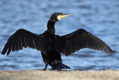
Great Cormorant: www.flickr.com
Museum of Victoria's Field Guide App for NSW help identify animals. It even has the calls of birds and frogs. Field Guide to NSW Fauna is a valuable tool for anyone with an interest in wildlife. Use it in urban, bush and coastal environments to learn more about the animals around you. 

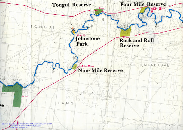
Now about 12 km into the paddle. The GPS is refusing to do anything but show it's start screen. Seems to have been an expensive mistake. Just have to wait a lunch break and try and see what I can do. I remember reading something about taking the batteries out and holding the on off button and then re-inserting the batteries and it should be right again. But I'd better wait until lunch when I have dry hands on moisture could get into the device. There is a fresh wind coming from the south-east so most of the time I'm heading into it. Following the map and the kilometres written into it, I am at about the 16 to 17km point - almost at Gordon Point at the 4 mile reserve.

Near Four Mile Reserve I come across an old shearing shed in the Wooloondool State Forest. It seems to be in the process of progressively being swallowed up by the bush surrounded it. The shearing shed is located in a convoluted peninsula with the river forming a natural boundary for stock on all sides except for a narrow 'bridge'. Early settlers often used the land to their advantage like this. In Echuca, what is now the Scenic Drive, used to be a holding paddock for police horses and near Kulcurna Station on the lower Murray, a similar landform was used to trap wild horses.
“It’s like the old days of camping when you and the family take the dog, park the trailer, set up for a week, live on fish, and it costs you next to nothing.”
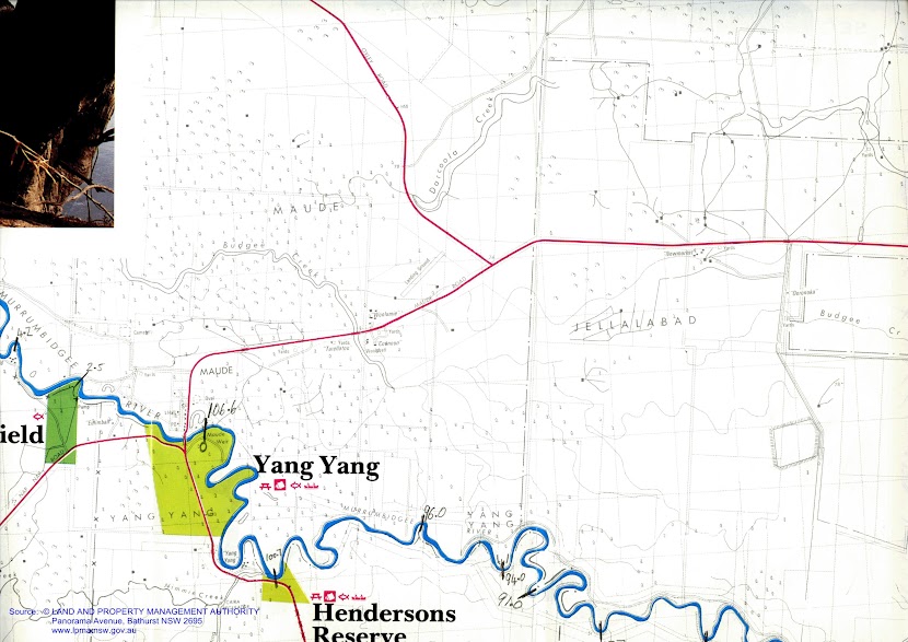
Wooloondool, part of Murrumbidgee Valley National Park, is within easy reach of the town of Hay, and it’s an ideal place to camp. Many set up camp at Wooloondool as it’s a great place for fishing - yellowbelly, redfin, brim, catfish, and carp, as well as crayfish during the season, can all be caught here." Wooloondool Reserve 


Just before Rock and Roll Reserve, about 18 km downstream from Hay, are the remains of a Fisherman's shack. Its roof is still intact, but the walls and floors have rotted away and only the frames of these and the front door is still present. I wonder if it was abandoned in the high rivers of 2010-11?

I have heard the beautiful calls of the Pied Butcher Bird through the forest. This bird is a bit of a conundrum. It looks like a stunted magpie, but instead of warbling and 'carolling', it whistles. Its song reflects off the gum leaves in the canopy and carries well over long distances. Despite its song and good looks, it did not get the name 'butcher bird' by chance, it has a habit of spearing its prey on thorns until it is ready to eat them. It hangs its meat to keep it fresh. The river this morning has also been home to pelicans wheeling into the sky on my approach, great cormorants, pied cormorants usually high in the dead trees that line each bank, australasian darters struggling to fly with crops full from the last dive, tree martins, brown treecreepers and pacific black ducks in their hundreds.

Android App: The Lower Murrumbidgee floodplain is a unique area. Use this app to learn about the Lower Murrumbidgee Floodplain and explore both natural and cultural wonders of the area. Investigate the diverse plants and animals of the Lowbidgee with over 100 species profiles presented and the ability to report a species you have seen. The app also includes information on things to do, places to visit, towns, national park information and a map. Visit the app's gallery to take the opportunity to share your Lowbidgee photos.
Approaching the weir the river nears the top of its banks.

Magnificent hollow in an old river red gum.

Trees flooded by Hay Weir provide habitat for water birds.

The hairpin bend just after Four mile reserve is a whistling kite nest in stately river red gum, taller than the rest of the trees, its crown reaching above the forest canopy. As I paddle past the tree, one of the kite gives its warning call, whilst the other circles overhead. The nest is small by eagles standards. I've recently learned that each generation adds to the nest and thus it becomes progressively larger with age. A nest near Bendigo has been documented to be over 400 years old. Later in the day I came across a much larger nest; it was about 1.5m tall and about the same wide.

White breasted sea eagle: Wikipedia
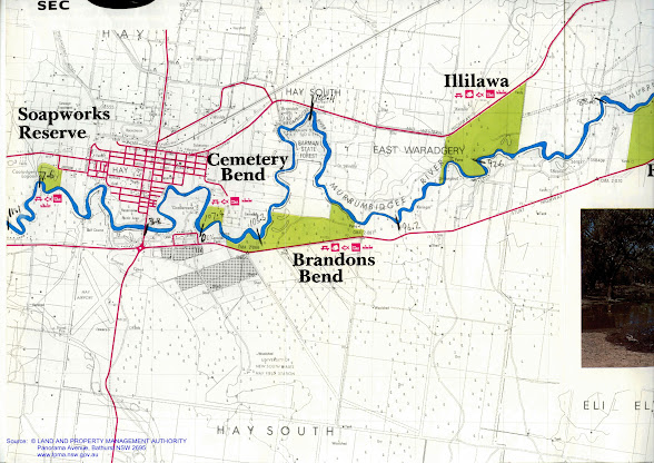
On the last hairpin bend before Hay Weir, a pair of white breasted sea eagles took to the air just above me. What a surprise! I watched their aerobatics for a minute or so, before they disappeared, one further down the river and the other to an impressive nest in a back water. I tried to take some photos, but the specks in my viewfinder turned out to be really specks and not much use to anyone. Despite being lovely pictures of clouds and a blue sky, I wont be uploading them to Facebook.


Watermarks showing normal water level

Spoonbill

White breasted sea eagle

Hay Weir was much bigger than I anticipated. I could see it through the trees as i approached. A tall rectangular structure, about the height of a four story building, it loomed ominously as I rounded the bend. The weir completely blocks the river and with no way of going through it (there are no locks on the Murrumbidgee) you have to get out. With the weir pool dropped by about a metre, I had to really struggle to get my boat up the bank - especially since being the first day, it was heavily loaded. Mike Bremers and the Great Millenium Trip blog talk of picnic areas, toilets and lawns kept green by sprinklers, however I was unable to find no more than a derive BBQ and some orderly piled rubbish from campers. It seems that it is not the place it used to be. To relaunch your boat, you need to follow the river for a couple of hundred meters until you are past the fenced off and rock protected bank. There, a fisherman's track heads down to the river. It's a different river below the weir; the banks are high once more and the current surprisingly swift.


Hay Weir appears like a gateway in the distance.

On the other side ther are no more dead trees

And the banks are natural once again.
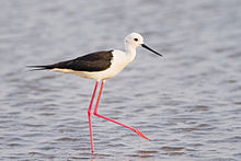
A pair of black winged stilts lure me away from their nest by flying ahead. All black and white except for long red legs. They look more like a seabird then something you would find in inland Australia. Once I am far enough away, they simply turn and fly back at head height right past me - obviously they are not used to being hunted (thank goodness).

Black Winged Stilt: Wikipedia
The river downstream from the weir is much more natural. The dead trees that have been my companions since Hay are gone and the river is less grey. the green of its water are complemented by living vegetation that at times comes right down to the water's edge.

There was a lot of water coming out of the weir. The flow at least in the first section is as good as the Murray. The wildlife seems less disturbed, though remains timid.

As the afternoon rolls on the sun comes out more, creating sparkles on the water's surface. It is a pleasure to paddle this section of the 'bidgee.


My first beach since leaving Hay.

The Lowbidgee winds through farm...

And forest...

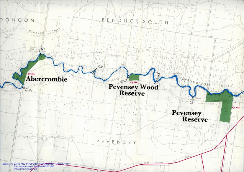
About 20 km below the weir I came across Pevensey Station, I felt nostalgic for the grand old steamer that is the pride of the fleet at Echuca. PS Pevensey was named after this wool station (wikipedia). She was known as the PS Philadelphia in 'All the Rivers Run' - a mini series from the 1980's which depicted the river trade. I stopped and tried to imagine what it would have been like in those days. I tried to take a photograph, but with the advantages of being close to the water in a kayak there have to be sone disadvantages - having a difficult time photographing things that are on top of the bank is one of them. I settled for a row of old fuel tanks (a snapshot of rural life) when it was the station I was actually interested in.

PS Pevensey... named after a wool station on the Murrumbidgee River.

Steamers were a connection with the outside world. Not only were they good for business, but they also brought visitors. Some were churches, like the PS Etona, and performed weddings and baptisms along the rivers. Others were shops, selling pots and pans and flour. Still others were fishing boats, like the PS Canberra and kept their fish fresh is netted half sunken barges towed next to the steamers. The PS Pevensey was one of the grandest of the wool boats. Wool bales were stacked until the captain could only just see the river and even higher in the huge barges behind them. They allowed this area and the people who lived in them to prosper and establish the great properties that still exist today. Rail brought the end of the river trade, just as road transport led to the closing of most branch lines almost a century later. Now the Murrumbidgee is full of snags and the weirs placed on this river do not allow the passage of boats as they do in the Murray. More is the pity.


Boats loaded with wool bales at the Echuca Wharf.


On this section...

There is..

A sense of isolation...

Ther is just you and the river...


Pevensey Station: fuel drums.

Pevensey Station


Not far after Pevensey, I found a large beach with enough room to pitch my tent out of reach of dangerous branches. I turned around, took aim and paddled hard so the the first half of the kayak would launch onto dry land. I then pulled up my boat, out of reach of a possibly rising river (following yesterday's rain and the amount of water that was being allowed through the weir.


My campsite near Eulalie Station, just downstream from Pevensey Station.


Wahlenbergia stricta: native bluebell. A plant which has survived from Gondwana times, it exists in South America, Australia, South Africa and New Zealand.


After setting up the tent, I settled into cooking, determined to eat my way through my boats food stores. I am sure I have brought too much. I usually do. Sitting watching the sun go down, whilst dinner cooked was very peaceful. It is the time of day when birds seem to wake up again,with either the urge to be social, or to eat - it is difficult to tell which is the case, they seem to be doing both.

Murray Rosella: the yellow form of the crimson rosella.
Spotted doves were feeding on the grass seeds on the beach, yellow plumed honey-eaters squabbled, Murray Rosellas found young buds on the red gums, biting them off to get to the sweet sap that feeds them. There must be a grey shrike thrush. These are a beautiful to listen to. Their song is almost as varied and inventive as a lyre birds'. Two strong looking young bulls came down too. Luckily they were not too curious. Better pack up well tonight though. Tomorrow I hope to reach Maude.


The spotted dove is native to India. It was introduced to Melbourne in the 1860's and quickly spread, sometimes replacing native doves (wikipedia) .Spotted Doves feed on grains, seeds and scraps. The birds are seen alone or in small flocks, feeding mostly on the ground (birds in backyards).