A journal of canoe expeditions along the rivers of Australia's Murray Darling Basin using photographs, stories and information to highlight the beauty, challenges and history of these rivers and the communities they flow through.
Murray River Paddle 2016 Day 26 Invincible Bend to Robinvale Nov 10
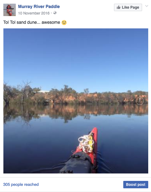
Tol Tol to Robinvale
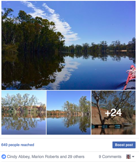
With only a short run into Robinvale today, I took time for a cuppa and a good chat with Jess, who had turned up for another day’s work at the farm. She brought in two avocados, one of which made a lovely lunch out on the water. It was a perfect day for paddling, no wind, clear skies and river landscape.
There were three notable points on the river today. The first two were sandhills, the biggest so far. The sandhill at Tol Tol would easily be 15m high and its little brother a few bends earlier was not much smaller. I agree with Andy and Albert Gorman, the down stream side of the first would have made an excellent camp. It had a gentle slope that ran into the river up from a black box woodland and was mostly covered in grass. Too many sticks are a bother when you have a tent.
The remarkable thing about these sandhills was that although they are generally very easily eroded, these had stood up to the high water and strong currents without any sign of bank collapse, or even damage. The difference between these and most other sandhills I have seen was that they had a belt of redgums and river myall had grown along their base, all but stopping the flow of water in front of them. Collapsing sandhills have been a problem along much of the last 1,000 km and particularly worrying for people who have their houses on them - great to keep above the flood waters - not great if they collapse. So the trick seems to be to vegetate the base.
Leaving 'Little River Cottage', a welcome dose of hospitality, kindness and company.
Perfect day for paddling; no wind, clear skies and impressive river landscape.
YouTube: Just after 1156 at the cutting downstream I can see a swallow capturing mosquitoes of the water surface, morning calls, dragonflies flitting across the surface of the water - they're always welcome - water is still and the sky blue…
Sandhill downstream of Tol Tol
Edges of sandhill make good camping spots.
YouTube: Note the stability of this sand hill, with red gums growing as a protective buffer to the currents of the outer bend. No doubt on sediments that have collapsed due to erosion, however this layer of vegetation both protects the sandhill and captures future erosion, allowing recolonisation by other red gums and you can see here, the Acacia stenophylla, and as the face becomes less steep, also by saltbush and grasses…
The third feature of note was Bumbang Island. This is a 12km piece of land which is now cut off from the rest of Victoria by the river, which is in the process of cutting a new course to its South. Saving kilometres is more efficient. Today the river was racing through there. There is a spot, just after a clay bar in the middle where there is a strong undertow. Logs have been seen to disappear there and only surface a hundred metres further downstream. I have been through this cutting at low water. I had no desire to take chances with the power it had in high water. Bumbang Island is an aboriginal reserve and wildlife sanctuary. Today, most of it was under water and there was very little current for the full 12 kilometres. If the water is shallow enough it could cause black water trouble for Robinvale, which is immediately downstream. About half way around Bumbang are the remains of an old post and rail stockyard. One corner of the stockyard is fixed by wire to the oldest black box I have seen in my journey so far. It was well over 2m in diameter. Given that black box grow much slower than river redgum, this would make it many centuries old indeed. Not many old trees remain, Andy Gorman of Meilman Station informs me, because when steam was still the primary source of energy in the bush people worried that they would run out of dried wood and Chinese labourers, seeking work after the gold rush were employed to ‘ring the trees’, leaving them standing until they were needed. Many are still standing. Black box is growing back, but since it takes such a long time to grow, it will be centuries until the landscape approaches its earlier form.
Floodplain forests of river red gum and black box. In the last image a spoonbill can be seen wandering along the top of the bank.
Wide smooth and dark. Flood waters nearing Robinvale were low in oxygen and high in organic matter.
.
YouTube: Small patch of saturated CPOM right of mid stream... Approaching Tol Tol and the sand dunes are definitely getting bigger.
The lower end of the second sand hill tapers off to provide good floodsafe campsites.
Groundcover vegetation amongst black box on top of the river bank.
Habitat trees on the bank edge. Approaching Bumbang Island.
A little further is a lagoon, hidden by the trees which have grown over the place where it used to join the river. The lagoon is the way to Euston Station. The original station, settled by Edmund Moray in 1846. It was Moray who embarked on a trip to Adelaide to propose that stem navigation on the Murray River had potential. The South Australian Government supported the initiative, setting a 2000 pound prize for the first steamer to reach Swan Hill. Two people answered that call, Francis Cadell and William Randell. Randell, with little ship building experience built the Lady Augusta near Mannum. It had a square boiler which was held together by chains because under pressure it began to swell. Cadell had his boat made in Sydney and delivered. Both were unaware of the other until arriving at Euston, Robinvale’s sister city, then the race was on. Cadell won by half a day, but both remained key figures in the development of the river trade which played a key role in the development of inland Australia.
To support that trade, 26 locks and weirs were planned along the Murray River. The idea being that boats would be able to travel along the river at any time of the year, that communities would not run out of water and that irrigation would be possible on a larger scale than was possible with steam pumps along the Murray River. Only 16 were ever built. Torrumbarry weir was supposed to be number 26, it is the furtherest up the Murray. After that comes Euston, which I will probably pass over tomorrow, given the height of the river. Nothing was built in between. Paddle steamers were overtaken by a steadily expanding rail network and the construction of the Hume Dam had begun in the 1930’s. They were seen as no longer necessary. The weirs remain a legacy of the past, but one which enabled the rich agricultural industry in this part of the state to develop. Their weir pools created permanent wetlands, which are important breeding sites for water birds and fish and the steady water levels are attractive to water sports and real estate development. From here on the river changes again. Particularly in low river, one journeys from weir pool to weir pool. Today, with a natural Spring high water event, that is not the case. I look forward to a different take on this section of the Murray River.
Wide river landscape approaching Robinvale.
Peaceful, slow flow around Bumbang Island - most of the current flowed through the cutting.
Company for the run into Robinvale: thanks Kia!
Historic sheep yards.
Dead river red gums in billabong flooded by water backed up by Euston Weir.
Robinvale's famous Oasis Pub... lost to fire. I had to find somewhere else for a pint and parmi
 With only a short run into Robinvale today, I took time for a cuppa and a good chat with Jess, who had turned up for another day’s work at the farm. She brought in two avocados, one of which made a lovely lunch out on the water. It was a perfect day for paddling, no wind, clear skies and river landscape.


No comments:
Post a Comment