Robinvale to Wemen


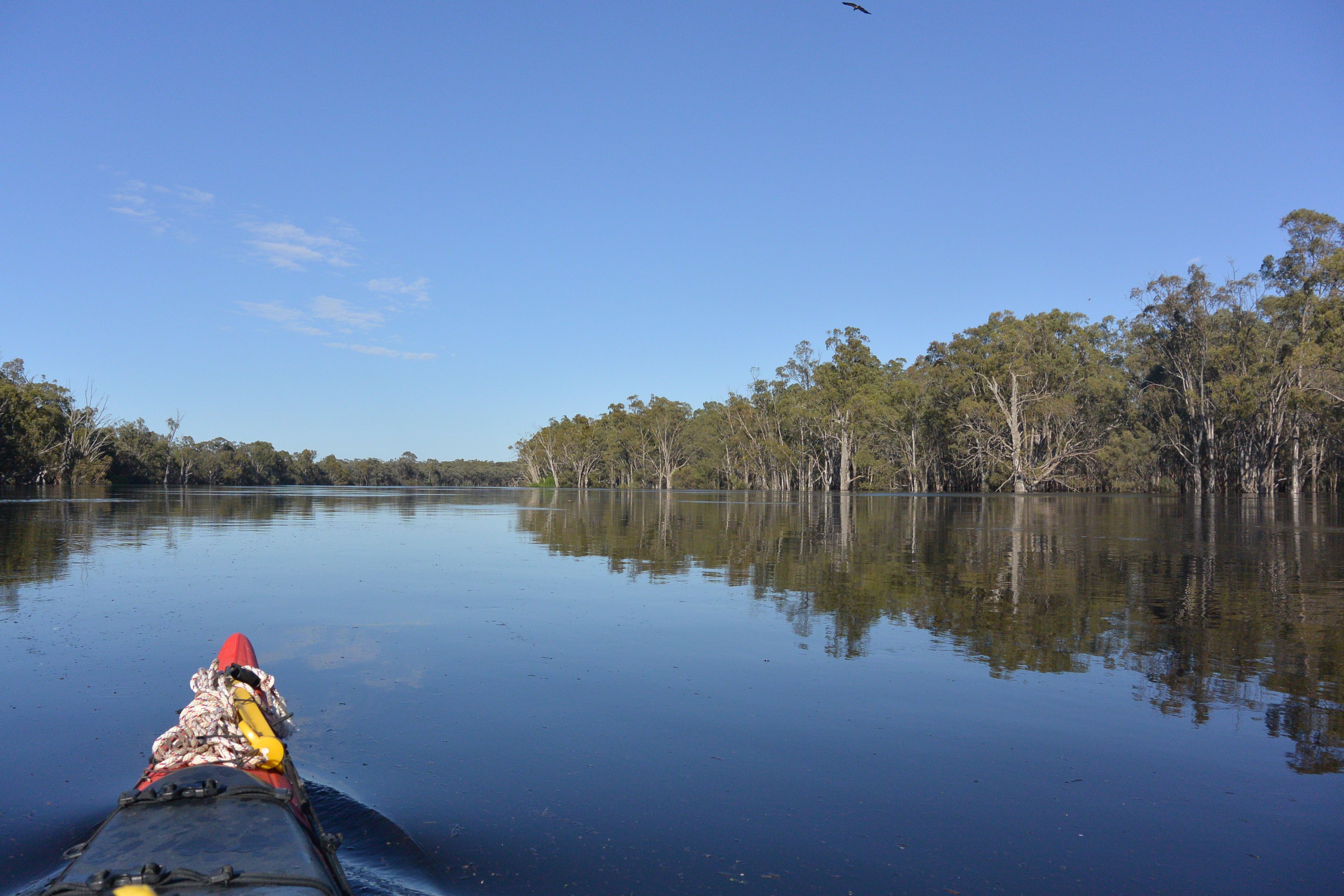
Paddling out of Robinvale caravan park was a bit surreal. I had to dodge the electricity poles that the caravans normally plug their extension cords into, watch out for fences and pick a course into the current through the garden. Once out it was through the bridge and down the wide, high river. The current was flowing well and there was no sign of the predicted light winds, providing the same glassy surface I had been blessed with he last few days. I passed Euston, older but much small than Robinvale, perhaps because NSW in the early days of settlement allowed Victoria to get a head start on them. Melbourne was much closer, but it meant that all the wheat, sheep and wool went to Melbourne rather than Sydney.


Towards the end of the paddle steamer days, both states competed to get rail to even the most distant communities, but by then one of the twin towns along the Murray had begun to dominate. It was usually the Victorian one. An interesting legacy from those times is that most NSW towns have Victorian area codes. Phone numbers in Deniliquin, 80km North of the border, begin with 03. Euston club looked really welcoming, especially as I could paddle right up to the green lawns leading to its entrance. It looked as if they designed that way, to be welcoming to river people. However, I had only just begun. There was no stopping now.
On quite a few days i have thought, I can take it easy today, there is a good strong current out there, only to find that large segments of the day had dead water. Although there were some tight bends and quite a few places where the river flowed along flood runners and anabranches through the forest, the current was good all day. There were no big anabranches, only cut-offs, short cuts the river had made when the meanders near one another. Its difficult to say how long it takes these meanders to become the main stream, but if they have a clay base it seems that it can take the best part of a life-time.
Around the corner from Euston is the Euston weir. When there is a high river, lock masters let down gates at the top of part of the weir to create what they call a navigation pass. This provides more depth for boats that want to pass over the weir. Because in most cases, the weir is still present beneath the water, water is higher on one side than the other, creating a ‘step’. Frank Tucker, in Oct 2016 Paddle Boat News, says that this system causes trouble for paddle steamers, especially when travelling upstream. To make it up the step, Captains have to approach the weir at full throttle, hoping to bounce up. If they do not have enough speed, or the current is too strong (and it really is quite strong now) then there is a danger that they will get stuck halfway, with the paddle wheel blades biting air. On the way downstream, the rudder can find itself in the air and the paddle steamer drifting sideways. Understandably with this deal of risk involved, it is not paddleboat captains favourite activity. In my kayak I was wary of undertows and so called the weir master, who directed me through the smoothest water. In a kayak it was like going down the smallest of slides. No drama, but better safe than sorry.
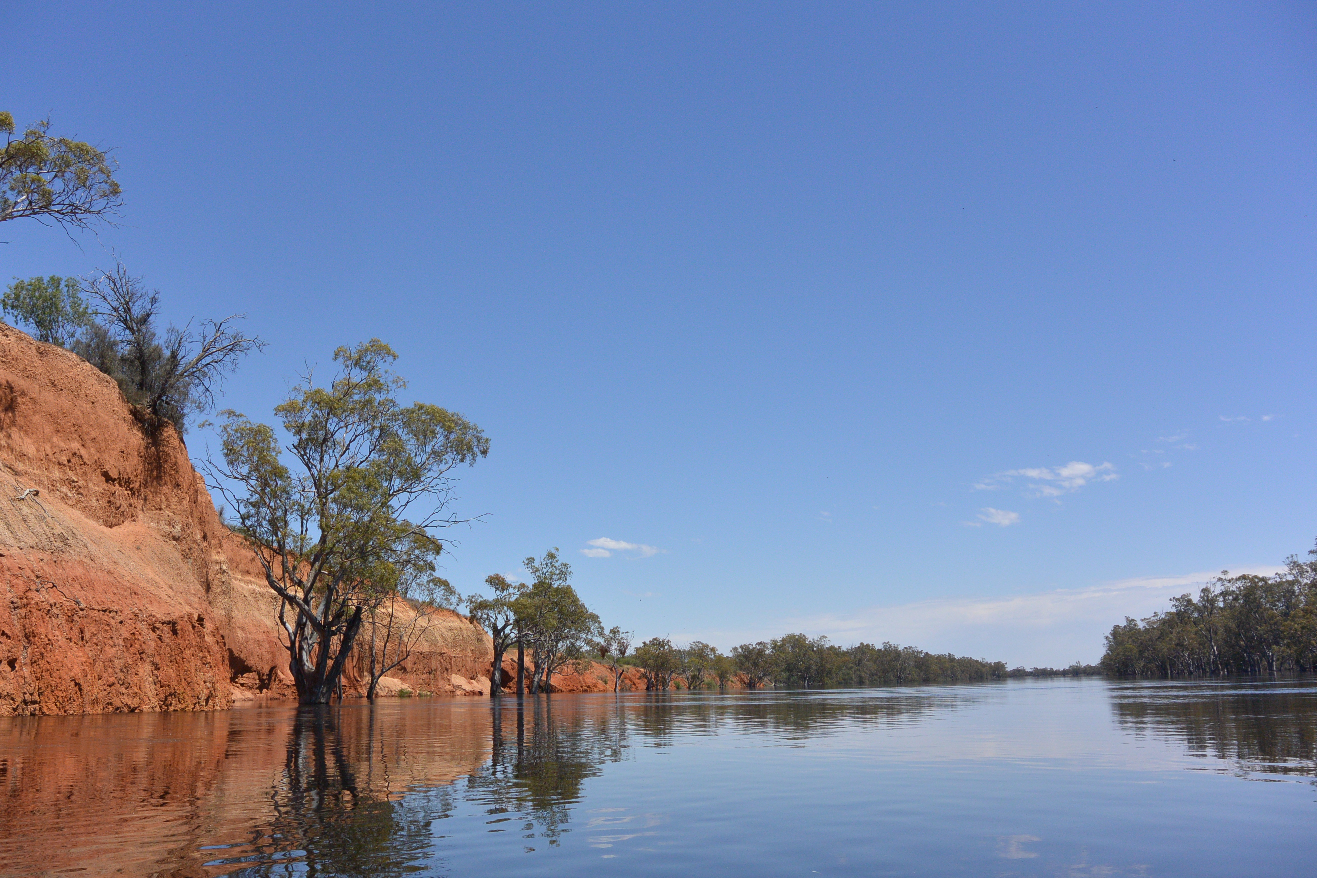
Euston weir is set into a high sedimentary rock face on one side. The other side is forest. If nervous about the weir, the lock master said, you can just paddle through the forest. The clay cliffs continue on for 2 kilometres. They have three clear layers, two red layers, with a yellow layer in between, each being about 4 meters thick. River Red Gum and River Myall, the wattle with the pen like leaves grow from its base and seem to be protecting it from the eroding force of the river current by slowing it down next to the cliff face. The vegetation was so effective at slowing the current, that it actually ran backwards close to the cliff. Where ever there are eddies and strong currents there are whirlpools, so breaking out into the current took some care. Ten kilometres later the cliff appear again, this time even more imposing. They make for great photos. I hope some of mine work out.

Red sands of the Mallee Cliffs. Old sand dunes, now being cut into by the river.


Tree martin nests. Safe on the face of a cliff. You can also find them under bridges or in large hollow trees. Preferred spots are over water.


Most of the day the scenery alternated between River Red Gum Floodplain Forest and Black Box Woodland, some of which was grazed. However, just when you settle into a pattern the river throws a curved ball. Just beneath Tammit Station (1078 mark) is Danger Island (also know as Gell’s Island). A lot of things that are dramatic at low river are hardly noticeable at high river (like Euston Weir), but Danger Island is not one of them. Even though you can’t see the rocks which extend halfway across the river - real rocks, and sharp too, that could slice a kayak or tinny open just by looking at them - the swirls (sudden vertical upwellings or downwards movements) were shocking and to make things more dangerous, they would appear in apparently calm water. Using the map as a guide to what was beneath the water I gave it a wide berth and travelled through with speed, so as to have maximum steerage.


Lunch break

Old pumping equipment. Before the weirs, all irrigation was carried out by steam driven pumps along the river banks.
Not long after Tammit, I made camp in the shade of two Black Box trees. All around me thunder is rolling through the clouds and in the distance I can see downpours happening in isolated spots. Occasionally strong gusts of wind come through. I am eating cold tonight and enjoying the comfort and safety of my tent. Though I do hope the predicted large hailstones pass me by.
Tomorrow I will be paddling through Hattah National Park and the following day hope to arrive in Colignan, then Karadoc and arriving in Mildura on Tuesday.

High organic matter content has dropped the pH making the water silky smooth to touch. Like when soapy, rain water forms bubbles which sometimes last for many seconds on the surface.

Strong current sweeping past a tree trunk that would normally be on a river island, but now looks like it is mid channel.

Old shed at Tammit station

My choice of campsite has been chosen by others before me... signs of a midden.

Tammit Station dry irrigation channel

My camp for the night

In the evening I was hit by a powerful storm. It flattened whole areas of trees (and my tent), but I escaped without damage.


No comments:
Post a Comment