A journal of canoe expeditions along the rivers of Australia's Murray Darling Basin using photographs, stories and information to highlight the beauty, challenges and history of these rivers and the communities they flow through.
Camp was just after a right hand turn, at the beginning of a straight at around 48 km.
Redbank weir is at about 90 km downstream from Maude. There is a place just before the weir (after the barrier) where you can pull up on a lawn. Camp is prohibited within the reserve, but there are good toilets and lovely picnic facilities.
Campsite 48 km downstream of Maude in the morning light.
It was difficult to get out of my sleeping bag this morning. I had set the alarm for 5:30 to be ready to pack at first light, however on waking it still seemed a little early. I still needed a torch to assist in finding things around the tent. I taped up a few potential blister spots from yesterday and lay back down. On the other side of the river the wind was loud in the trees. It sounded loud anyway. It always does in the trees. Knowing what it can do to its branches is why you don't camp beneath them. My spot must be sheltered, as my tent is barely stirring, but I know that there will be straights in the river where it will push me around a bit. Combined with the invariable water splash from my paddles meant it would be cold on the water. Lying in a warm sleeping bag seemed a good alternative.
Wildflowers
There was also the morning chorus to listen to. The kookaburras set it off, almost in a false start at about 4:30, then realising that they were the only kids on the block waited another half hour. As dawn neared progressively more birds joined in. Too many types to identify, but each, it seems has its time. The galahs and crows were amongst the last, whether that is because they just take a bit longer to warm up, or whether they just like the sun, I don't know. Murray rosellas, with their bell like voices and chatter are calling to each other near my tent. Time to get up and face the day.
Fisherman's track along the top of the bank behind my campsite.
Look what i found under my tent when I rolled it up this morning. Needless to say, I let it crawl away.
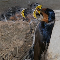
Despite there being a track running along the top of the bank near my camp, the only sounds are natural ones. Out on the river I saw two wedge tailed Eagles, both of which took off as soon as they saw me, their powerful wings driving them through the air. Generation long habits of shooting them because of the damage they inflict on young lambs has made them wary. Tree Martins and a welcome swallow chase insects in a showcase of acrobatic flying over the water.
A visual comparison between tree martins, fairy martins and welcome swallows.
Tree martin
Fairy martin
Welcome swallow
Tree Martin Birds in Backyards... The tree martin’s nest is a relatively flimsy structure made from dry grass, leaves and sometimes feathers (2) (3), although it will occasionally use some mud or even build a full mud nest (3). If a crevice is used, the tree martin may reduce the size of the entrance using mud pellets mixed with plant fibres. It has also been known to take over the nests of welcome swallows (Hirundo neoxena), building up the walls with mud and lining the nest with leaves. Tree martins may reuse the same nests over a number of years (2) (3). Arkive.orghttp://www.arkive.org/tree-martin/hirundo-nigricans/
A young female Grey kangaroo hops along the bank towards me, when she notices me, she stops and stares curiously. Eventually I am the one who moves on. A line of dusty fawn emus walk through the bush noiselessly and are gone.
The Murrumbidgee is quiet, narrow and snaggy.
About to head off. 8am. Looking a bit scruffy.
The grey Murrumbidgee mud, here pock marked by cattle hoof prints, is incredibly sticky. When it is the slightest bit moist it holds like glue. Walking over it after rain, it cakes under the bottom of your boots, or around your car tyres. The cattle had polluted this section of river bank with their droppings, making it difficult to find fresh water.
The Murrumbidgee really should be called eagle river. Few kilometres further I saw another 4, two close and two others soaring high in the sky. In the last three days I have seen at least ten white breasted sea eagles too. Paddled past Mungary Station at 10 o'clock. It is a modern lived in building. They are not so frequent around here and good to know that you could seek help there if need be.
Red bellied black snake crossing the river. They are good swimmers. I actually saw one with its whole body under the water except for the tip of its nose, until I had passed, then up it came and swum away.
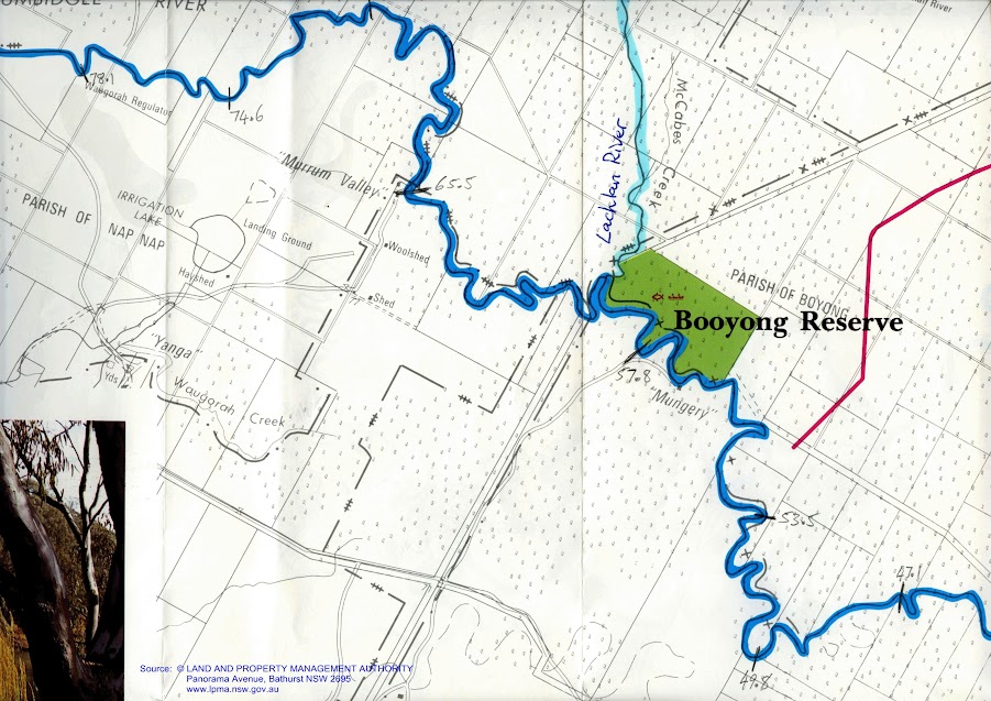
Where what remains of the Lachlan River (after it has sickered into the ground in 80km of swamp and floodplain landscape) enters the Murrumbidgee River.
Opposite the Lachlan, the Murrumbidgee goes round a sharp hairpin bend.
I was looking forward to a short paddle up the Lachlan. However a large tree lay across its entrance so it was not to be. The catchment of the Lachlan is comparable in size to that of the Murrumbidgee. The tiny stream that enters the Murrumbidgee gives no clue to that grandeur. One of Australia's first inland explorers, Oxley was frustrated by swamps when tracking the westward flowing Lachlan and Macquarie rivers. Charles Sturt, who heard of a great river to the South, located and travelled along the Murrumbidgee to determine whether it did the same (source). As Mike Bremers noted in his blog, it is a rather small river for one so long. Modest, except as with all the rivers around here, when they flood. Sturt followed the Murrumbidgee from Gundagai by land. It was not until just upstream of the Lachlan, that he launched the 9 metre whale boat his party had transported in pieces from Sydney. They also built another smaller boat, for their provisions. It hit a snag and sunk (along with most of their food supplies) on the second day.
Straw-necked ibis and freckled ducks in Booligal Wetlands, Lachlan Valley, during spring 2010. Freckled ducks are listed as vulnerable in NSW. Following an environmental water release, four pairs of these ducks nested and bred in dense lignum that also supported nesting of over 60,0000 pairs of straw-necked ibis. Photo: Paul Packard, OEH.
The Lachlan catchment has an area of 90,000 square kilometres, extending from the Great Dividing Range to the Great Cumbung Swamp on the Riverine plains. The Lachlan has three areas of particularly high environmental value: Booligal Wetlands, Great Cumbung Swamp, and the Lachlan Swamp (map). All are listed in the Directory of Important Wetlands in Australia.
Coming up to Murrum Valley Station. Some strong wind gust coming from the north making the trees roar and sending white capped waves down the river.
Murrum Valley Homestead
Nearing Redbank Weir, the water level approaches the tops of the banks. Regulators control the flow of water into and out of the forest.
The Murrumbidgee in the last ten kilometres is like paddling through the narrows but without the current. The river is right to the top of the bank, which means I will have no trouble getting out. The river banks, like the narrows, seem higher in places than the bush either side. Just before Picnic Point on the Murray are signs to stop the waves from wake setting boats from eroding these and flooding the forest. No need here it seems; even on a school holiday weekend there is not s soul to be seen.
Approaching Red Bank Weir with high water. In this shot you can see how I have rigged the solar panel on the back. Not knowing if I could rely on a recharge for my batteries, I worked out this set up with my son, Tim. It includes a 17Amp sealed battery with heaps of power for my laptop and all the other devices. I use a cupholder inverter and then the leads the equipment was supplied with.
The bush always looks at its best in the afternoon sun.Note the high water level, as the river approaches the weir.
On a south west reach of the river, not far from Redbank weir, I let the wind carry me: it's been in my face for most of the day, as the Lowbidgee winds north west. From Redbank onwards it strikes a southerly direction once again, onwards to the Murray.
Arriving at the weir I asked a man in a fishing shack where the best place to pull out would be. He suggested that I pass through the safety barrier, not straying too close to the weir as the gates were open, and then get out at the grassy area - which I did. It turned out that he is the caretaker and the head of a nest of red necks. Two of his sons came upstream in a tinny. One standing in the front with a shotgun, shooting at anything that moved. They waved at me, though for a second I thought they would teasingly point the gun my direction. They continued blasting as they travelled full speed (with their smallish motor revving its heart out) 'Apocalypse Now' style up the river. They came back later and continued blasting. God save the wildlife (and them: there was a sign saying 'Yanga National Park, no hunting'. Ok, I decided not to ask for a hand with my gear. Later, on land, I spoke to one of the older fellas. He built the shack. His friend was the caretaker, but he had moved into town. They come about ten times a year to hunt. Good news, no more crazy caretaker. Bad news, he has some crazy friends.
My GPS (it's working again now that I've put in alkaline batteries) shows that the total distance from Maude to Redbank Weir was 97 km which means that I paddled about 49 km today. With the slow current and headwinds that took me 7.5 hours, with an average speed of around 7 km/hr.
This stretch has definitely been a pretty paddle, with the wildlife, in particular, the wedge tailed Eagles, emus and kangaroos a highlight. Surprisingly, about 10km upstream of Maude are a series of new camping areas, each with picnic tables and toilet block. These weren't on the map, but as far as I am concerned, are a welcome development.
This shot is to show the regulators in use above Redbank Weir. This is one of the new ones. The bush looked pretty sad in places. It seems to be still recovering from the last drought. environmental watering (occasional flooding mimicking the natural cycles) is important to them looking healthy again.
Approaching redbank weir. Sunlight on reeds.
There were familiar sights too, a pelican who takes off with his head to one side, as if to say, 'Hey man, you might not realise it, but this taking off business takes s lot of effort. Why do you keep following me?' I have been following him for 60km. Finally today he let me pass him without taking off.
Downstream from Redbank Weir at 1,800 ML per day. Lee Baumgartener's 2005 study into the effects of Redbank Weir on fish migration found that the Redbank and Balranald weirs obstructed fish migrations during summer and autumn and many species of small-bodied fish such as Australian smelt, western carp gudgeon, fly-specked hardyhead and crimson-spotted rainbowfish accumulated downstream of Balranald Weir. In addition, downstream accumulations of juveniles of larger-bodied species such as bony herring, common carp and goldfish were also detected. A simple fishway was built at Balranald, but no ladder exists at Redbank, effectively halting native fish migration at this point in the Murrumbidgee.
Downstream from Redbank weir at low river (Flicker) at approx 700 ML per day. Redbank Weir was built to composite landholders for the lack of natural floods that occurred after Burrinjuck Dam was built in 1909. Redbank Weir was built in 1940, just after the outbreak of World War II, funds to finish the project were diverted to the war effort. leaving levees necessary to water the flood plains incomplete. On the 9th of December, 1944 the Sydney Morning Herald reported that 100,000 sheep died when the rich river flats instead of supporting lush grass growth, were grey and cracked, 'as dry as any desert'. Arguments between the states exacerbated the problem. The Murray Darling Basin Plan aims to balance the interests and rights of all states and interested parties, from the river's source to sea - an unenviable task.
Tasting the forbidden fruit.... ah! Such a treat to be able to lie down after 8 hours canoeing.
A last parting thought. I the Millenium Paddle Blog and Mike Bremer's Murrumbidgee Blog, they mention stony ground 'reefs bedded with stone', I have noticed this in my last campsite in the middle of the bush and all over the bank. At Redbank weir there are great clumps of the stuff, a real outcrop. The stone is a type of limestone that forms when calcium carbonate rich ground water repeatedly reaches the surface and retreats. I think it occurs were ancient seas left behind subsurface soils with a high shell content. So when you see those rocks, it is a greeting from the time when the inland sea reached as far as Kerang, and, dare I say, Redbank
.
I woke up fairly early and walk into town for a last look around. Maude is a tiny place. Its three places of note are the weir, the shop and the pub. I took a few more photographs, used its very clean toilets and began to pack up camp and portage my gear. Maude,with its two streets, has been a first place getter in category A of the 'tidy towns' competition. They know their stuff. The toilets in Maude are a sight for sore eyes. Not only do they mean that you don't have to dig a hole and squat, but they are the cleanest public toilets I have ever seen. The nicely painted walls were unblemished by marks or graffiti. There was a full and working soap dispenser and the porcelain was clean. I felt some satisfaction at having discovered a new national treasure, worthy of inclusion in the best guide books. A sign on the wall pointed to the pride the locals had in their facility. "The shire of Hay maintains these facilities. Last cleaned on 12/9/09. That is just over four years ago. I think the locals must do it. I hope so.
8:03am Portage going well. All food back in the boat. About to pack up the tent and carry it over.
8:45 Last portage of gear coming up and then on my way.
According to the drunk old man who was wet from falling in the river and helped pull my boat, the section from here to Balranald is the prettiest. He has been all along the Murray, Edwards, Murrumbidgee and Darling Rivers. It didn't stop him from hitting snags though, you should of heard his late night torkle home. I think he may have gotten stuck on some. You could hear the swearing, clunking and revving of his motor for kilometres. He had to be rescued by his friends, and even they hit a few snags. Best not to have too fine a boat on the Murrumbidgee.
Maude weir was built in 1940 by the Murrumbidgee Irrigation Authority to compensate landholders from the lack of natural floods after Burrinjuck Dam (built in 1928) by sending water down the Nimmie-Caira Creek system. Proposals to use the water in the Murrumbidgee more effectively began with the frustrations that paddle steamer operators experienced in getting suppliers to and trade from landholders. Stations on the Murrumbidgee could only be accessed in high river following the snow melt, a period usually no more than three months. Luckily, this time also coincided with the wool clip, however, it meant that stations and towns along the Murrumbidgee did not have an effective transport system for 9 months of the year. A system of locks and weirs were proposed early in the twentieth century to allow access all year round and provide flooding of the low country, whilst also making it possible to develop more land using irrigation. Landholders were suspicious as they depended on the floods to replenish soil moisture levels and initially fought against regulation. Maude weir was one of the last to be built on the Murrumbidgee. Of the 9 initially proposed, only 4 were built, of which the primary purpose of the two at Hay and Balranald weirs was to provide water to those towns. As a result, much of the floodplain lost its natural pattern of watering. A series of droughts ending in 2011, as well as growing pressures to use the water in the Murray Darling Basin more effectively and for fairer distribution of this resource led to the Murray Darling Basin Plan. This plan described how water would be shared between the states, between towns and farmers, and between people and the environment. Because water is such a valuable resource in Australia, its use is often contentious. In the upper parts of the Murray Darling Basin catchments, people find it hard to understand why they should not use all of the water that is flowing past their door. At the bottom end, this is a lot more obvious.
"The Lowbidgee floodplain is the largest area of floodplain wetland remaining in the Murrumbidgee Valley. Located between Maude and Balranald, the floodplain covers an area of over 2,000 square kilometres. It includes the second largest red gum forest in Australia (along the river downstream of Redbank Weir) and significant black box, lignum and reed-bed communities. The wetlands support large numbers of waterbirds, many of which breed in the extensive lignum swamps, and provide habitat for many threatened species.
The aquatic and terrestrial environments of the Murrumbidgee catchment provide habitat for a large number of significant species and ecological communities that are listed under the Threatened Species Conservation Act 1995.
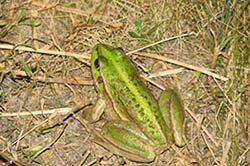
Southern bell frog, Lowbidgee. Photo: Sasha Healy, OEH. (Source)
Eighty threatened animal species are found within the Murrumbidgee catchment, 20 of which are considered endangered. This includes eight species of frogs, seven bats, 43 birds, eight reptiles and eight marsupials. Many of these species are reliant on the riverine forests, woodlands and wetland habitats associated with the Murrumbidgee River. There are 54 threatened plant species, of which 29 are considered endangered. There are five endangered ecological communities. Most extensive in the Murrumbidgee is the inland grey box woodlands that occur on the riverine plains, and the box-gum woodlands (comprising a mix of white box, yellow box and Blakely's red gum) that occur on the lower slopes and plains. Due to their location on fertile soils, both of these woodland communities have been extensively cleared. Remnants tend to be fragmented or isolated, and a full range of flora and fauna species is rare.
Several fish species that previously occurred in the Murrumbidgee River are listed as threatened under the NSW Fisheries Management Act 1994 (Table 3). Some of these have not been found in recent surveys and are thought to be locally extinct within the Murrumbidgee River (Murray hardyhead, river snail, olive perchlet, and southern pygmy perch). Breeding and restocking programs are in place for trout cod, purple-spotted gudgeon, silver perch and Murray cod within the Murrumbidgee River and its storages.
The lower Murray River aquatic ecological community includes all natural creeks, rivers, and associated lagoons, billabongs and lakes of the regulated portions of the Murray River below Hume Weir, the Murrumbidgee River below Burrinjuck Dam, and the Tumut River below Blowering Dam. These lowland environments typically have meandering channels and wide floodplains, and provide a range of aquatic habitats including pools, riffles, billabongs, snags and aquatic plants. The ecological community includes all native fish and aquatic invertebrates within these river reaches, and includes 23 native fish species and over 400 recorded native invertebrate species." NSW Office of Water. Water Resources Overview and Management. Murrumbidgee Catchment. 2011
The last part of the portage involved sliding the boat down a steep, root covered bank. At the bottom of this bank are some star spikes, so you have to be careful. All up it took me over two hours to get around the weir and have my boat ready to paddle again. A land crew with a car and trailer would make this easier, as would phoning ahead and organising to have the gates unlocked, so that you don't have to slide your boat over a 2 m high fence and all of your gear under it as I did. Whilst it was helpful to have a plastic boat that bounced, having a key to open the gate would have been easier. Try contacting the NSW Office of water at Dubbo on 1300 662 077, or Helpdesk@statewater.com.au. Alternatively, try the Maude Post Office Hotel (02) 6993 6112.
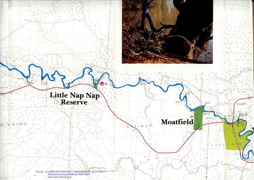
I finally got on my way at 9:45. About 5 km after Maude is the 17 000 acre sheep, cattle and organic cropping property, Moatfield station. An old original station building and two new looking smaller buildings are visible from the river, however, as usual, there is much more beyond the bank, including shearing sheds. The owners, the Nelson family, have been on the farm for generations. They offer on station accommodation using the "Farmstay' network and invite people to use their farm as a base to explore the area whilst getting to see and take part in some of the day to day activities of living in the country.
A majestic sea eagle, not concerned about me at all as it circled in its thermal low over the river.
People who have paddled this stretch before me say that it becomes a series of pools separated by clay reefs, which the river then runs over. I can imagine there would have been times when there was not enough water to pump. A stark contrast to the high rivers following the snow melt before the river was regulated. Yesterday, I saw a clue to how powerful the Murrumbidgee can be. Snags were washed up on a tree on the outside of a bend way higher than any other I had seen. I think that the force of the water going around the bend pushed them up. The Upper Murray banks around bends. It can be a metre higher on the outside of a bend than on the inside. Imagine that scaled up to a river the size of the Murrumbidgee. I would not want to be anywhere near it then.
12.3 km downstream from Maude I photographed a derelict pump next to a gnarled old tree. Both symbolise to me what a tough land this can be to live in and the tenacity of our pioneers.
Lowbidgee beach: they are smaller and more selten than on the Murray.
In the sunshine, the fleece on sheep really does shine as white as snow.
12;17 : 20km, lunch break. Current today is varying between 1 and 2.5 km an hour. There are slow sections and the occasional shoot, where you experience a temporary burst of speed. So far the GPS is behaving itself. I bought a set of alkaline batteries at Maude, which although expensive, I considered fair trade for the fresh water from the rainwater tanks, which-had "just been filled up yesterday."
Today has been perfect paddling weather. The sun has been shining all day and for the most part, it has been wind still. The Murrumbidgee has been much prettier downstream of the weir (as the locals predicted). The areas of bank erosion from stock are limited and the dead zone between low water level and normal weir level does not exist. It seems a healthy river. In that respect, I am glad for every snag. Like the aeration arms at waste treatment plants, the ripples the current causes as it flows through them add oxygen to the water, creating ideal conditions for the natural food-chains to breakdown nutrients and stop things like algal blooms from happening.
The sheep seem to have it pretty good; access to water, shady gums and a peaceful life.
Sheep enjoying the afternoon shade.
The campers are also fewer than above the weir, though one group of dads and their sons is worth telling about. As I approached, two young boys came sliding down the bank, waving and giving the thumbs up sign. They wanted to know where I had come from and where I was headed. Hay, I replied. Where's that. Oh about a hundred km that way, I said, pointing upstream. And where are you headed? To the Murray. Gees, that's like for ever away!
In the background of this picture, a cable stretches across the river.
Just after my last break, 20km from Maude, I passed Nap Nap Station. It is one of the most elaborate stations I have seen on the river. The older homestead is classic in style, but there was also a newer brick building that looked as if it was a renovated storehouse. It had twin peaked roofs, each with a circular window. Near the older building stood a windmill and next to that, a large water tank made of redgum sleepers, raised up off the ground on sturdy legs. The whole structure looked old, solid and in remarkably good condition. Behind the original house was a tall sequoia dendron, the Californian redwood. These among with palm trees were signals to the paddle-steamer captains that they were approaching a station. It must also have symbolised worldliness and western culture amongst the isolation of the bush. Crews would have enjoyed the hospitality of the station staff - for as long as they were allowed, until they had to be off again, and the people on the station would have enjoyed news of the outside world and perhaps even a recent newspaper from Melbourne or Adelaide. Quite to Sydney's consternation, settlers along the Murrumbidgee considered themselves more Victorian than NSW. Though, this is hardly surprising, given that that is where their markets were and where their goods had to be ordered from. The loss of trade (300,000 bales of wool I one year alone) is why NSW built railways to every river community between 1880 and 1895. These railways signalled the end of the boom period of the riverboats, though some continued on even up until 1950 as logging steamers and into the 1970s as passenger boats. The revival of interest in the boats keeps our history alive. It is just s pity that the weirs stop them from coming up the Murrumbidgee.
After the group of dad's and their sons, I haven't seen any people. I followed a group of eight pelicans for what must have been ten kilometres, always taking off and landing - but no people. It was only later, when I received an SMS from my wife, Ruth, that I realised where everyone was and what they were doing. It was the day of the AFL (Australian Rules Football) Grand Final. Almost everyone watches it. Whilst we lived in Germany we did so religiously too. It is a big part of mainstream Australian culture, uniting religious and ethnic divides. For some, the footy team you belong to is a big part of their identity, and champions are like gods. I hurried to make camp, to tune in the the last of the game.
Nap Nap Station has a large water tank made of redgum sleepers, raised up off the ground on sturdy legs. The whole structure looked old, solid and in remarkably good condition.
Nap Nap Station
As I approached 43.7 km on Mike Bremer's map (about 46km on my GPS) I kept an eye out for the place where Sturt launched the whale boat which he rowed down the Murrumbidgee, into the Murray, to the ocean and back. He was on a quest to find out where the westward flowing rivers went. Sturt became frustrated walking across the Hay plains and decided that it might be a good idea to build a boat.
One of his team, a carpenter, constructed the boat from pieces they had carried with them from Sydney. The whale boat was 9 metres long. A second boat for supplies, was also built. Sturt launched his boat between 10 and 20 miles upstream of the Lachlan junction. Earlier paddlers have identified a tree which is meant to be the place he launched his boat. Assuming that river geography has not changed that much, it would have been at a place where there was a gentle gradient in, like a beach. I photographed all of the beaches in the area, promising to share these with Mike Bremers, who, hopefully, will be able the tree he stood under as his new boat entered the river.
Possible site where Sturt launched his whale boat to begin his journey down the Murrumbidgee, into the Murray River and then into the sea. He had carried the whale boat in pieces from Sydney and had been following the Murrumbidgee using bullock drays and horses since Gundagai.
I think he would have picked a gently sloping bank with a beach, so I photographed each of the beaches between 10 and 16 km upstream of the Lachlan Junction. Sturt himself was not specific about the distance, so it could have been any of these, or others, further upstream.
I found a camp on a high bank above a clay ledge, just after where Mike Bremer's map says 44.7. My GPS reads 48km. The top of the bank is clear of dangerous trees and it is only a short walk up to where I have placed my tent. With my clothes hanging in a tree to dry and dinner on the boil, I am soon ready to enter my tent and rest. On journey's like these I find my tent like a cocoon, warm and dry, mossy proof and dust free enough to allow me to tend to my gadgets.
Evening chorus is strong and varied tonight. There is a bird which has a high pitched reverberating call which does not stop. It must be able to call breathing in as well as out. Murray rosellas, galahs, honey eaters, friar birds and wattle birds join in. There is a wood pigeon booming his call through the trees, and now gradually kookaburras are starting up, a whole bunch as usual, drowning out the poor wood pigeon. Beforehand there was a bird across the river whose call was continuos high pitched- maybe a triller. The wood pigeon has stamina. He's not giving up.
I paddled 48km today. Not bad given the late start (9:45am). The portage around Maude weir took a lot of time. If you are planning to do this trip it would be well worth your while to talk to a local first about some easier options than the ones I took. I spent just over 6.5 hours on the water, averaging around 8.5km an hour, but in some sections was as slow as 7km/hr and other as fast as 10.5km/hour. The current flowed between 1 and 2 km/hr. With an early start, I hope to make Redbank with enough time to portage tomorrow.


.JPG?itok=PvC_Yk1t)


