This page focuses on the experience and needs of the Echuca-Moama community in which I live.
Real Time Info on River Heights
Warnings and Updates

- Flood Warnings: Bureau of Meteorology
- Victorian Weather and Warnings
BOM River Heights
 |
| http://www.mdba.gov.au/river-data/live-river-data/yarrawonga-to-euston |
- Murray River - Tocumwal - Gulpa Creek -- Torrumbarry
- Goulburn River - Seymour - Murchison - Shepparton - McCoys Bridge
- Campaspe River - Redesdale - Eppalock - Barnadown - Rochester Syphon
Dam levels
- Storage levels in dams on Murray, Goulburn and Campaspe Rivers
Community Support and News
News Radio

ABC Local Radio
- With its network of more than 60 local radio stations throughout Australia, ABC Local Radio is uniquely placed to communicate emergency updates to communities affected by natural disasters.
Listen to yourABC Local Radio station for information, advice and updates.
Flood News on Twitter

- Victoria Police,
- CFA, or
- type "Echuca Floods" into the search bar
News Websites:

- ABC News Feed, (on floods from around the country).
- News.com.au 24-7 Flood info,
What To Do In An Emergency
- SES Flood Safe Week
- North West Region Flood Response Plan.
- SES Emergency Plans and kits
- After the flood.pdf - Campaspe Shire

Regulations
Flood Zoning
- Flood Map (Echuca, Moama)
- Campaspe flood extent 2011.pdf (94.7m on Campaspe River Gauge).
- Is your house in an urban floodway? (www.land.vic.gov.au)
- Campaspe Shire Flood Emergency Plan
- Campaspe Shire Council Flood Response Plan.
- Floodplain development plan Oct 2010 -
History and Records

Flood records at Echuca Wharf (source: Port of Echuca)

1870 – 96.19 metres
1867 – 95.34 metres
1916 – 94.79 metres
1975 – 94.79 metres
1993 – 94.77 metres
1956 – 94.57 metres
1974 – 94.51 metres
1917 – 94.50 metres
1889 – 94.35 metres
1906 – 94.32 metres
Jan 2011, 2016 Floods
- Campaspe shire Flood Info Page January 2011 Campaspe Flood Peak (when and where).
- Campaspe River Major Flood Warning.pdf
- Echuca-Moama-Torrumbarry Flood Modelling (interactive ArcGIS Map)

In times of need, people in our rural areas are famous for pulling together and supporting each other.In 1956 towns along the River Murray were tested to their limits - Story

EMagazine: Echuca Most Memorable Floods
Personal stories:
Community Stories: Wentworth
Wentworth floods 1956
The Argus
Newspapers - article display
1932 CAMPASPE RIVER OVERFLOWS (Rochester)
1917 The Argus: The Murray Flood: River Still to rise - Danger to Echuca - Immense areas submerged
1875 FLOOD AT ECHUCA.
1870 THE FLOOD AT ECHUCA.


Defences

Torrumbarry Wier with all gates raised

Loch Garry on the Goulburn River downstream from Shepparton.
Torrumbarry Wier

Features of the Barmah floodplain area that were influenced by geomorphology events. (Stockwell, K. 2010)
The primary result of the Cadell Fault is that the west-flowing water of the Murray River strikes the north-south running fault and diverts both north and south around the fault in the two main channels (Edwards and ancestral Goulburn) as well as a fan of small streams, and regularly floods a large amount of low-lying country in the area. These conditions are perfect for River Red Gums, which rapidly formed forests in the area. Thus the displacement of the Cadell Fault 25,000 years BP led directly to the formation of the Barmah River Red Gum Forests
Levees
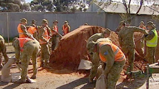
Soldiers fill sandbags in Echuca 2020 (ABC News)
Ecology
Barmah Forest and floods

Thousands of years ago the Murray flowed north of Echuca, along the course of what is today called Green Gully. It was the Goulburn River that flowed through what is now Echuca. Tectonic activity caused the land to the west of the present Barmah-Millewa Forest to be uplifted by between 8 and 12 metres along a north-south fault line, sloping back down to the west (the Cadell Tilt Block). The Cadell Fault Line runs between Deniliquin and Moama. The same fault continues south from Echuca to Runnymeade (Lake Cooper and Green Lake lay immediately east of this fault). The westward course of the Murray was blocked and a huge lake formed as a result. Earth movements along this fault are still occurring. The uplift was thought to have occurred about 16,000 years ago, give or take a few thousand years.

How floods shape rivers

currents undercut a redgum at the Campaspe junction (Riv Herald)

gradually changing the river's shape
- river beds move over time
- erode and deposit
- leave behind billabongs
- move sediment
Student Tasks
GEOGRAPHY
- Zoning and Flood Risk
- Find out which zone your house is in by reading through the above documents and the Flood map from the Shire of Campaspe.
- How flood prone is your house?

 |
| ABC - Goulburn downstream of McCoy's Bridge |
MEDIA
Current News Articles
- Make a folder with the news articles you find by searching your local paper and the links below. Don’t forget to say where you found the article and what year it is from.
 |
| ABC News Feed (automatically updated) |
Past articles
Video:
- 2010 - Jan 15 Rochester Floods - 9 MSN News
- Flood watch in Echuca (ABC)
- Floods continue to threaten Victorian towns (ABC News)
- Towns brace for flood arrival (ABC)
- Murray to burst bank at Echuca (The Age)
- Levee Bank Warning for Goulburn River (Sky News)
- Stateline video,
- Flood waters begin to recede (ABC)
- Floodwaters breathe life into lower
- Floods could stay water reform (ABC)
- Vic Floods good for farmers and fishermen (ABC)
- Flood waters breathe life into lower lakes (ABC)
- Farmer see silver lining to grey clouds (ABC)
- Floodwaters to enliven Victorian parks (ABC)
- Boat operators confident authorities won't repeat ban (ABC)
- River peak still to come Riverine Herald
- Floodwaters recede across Victoria ABC News
- Flood review held up in red tape The Age
- Soldiers sandbag Echuca ahead of flood peak ABC News
- Floodwaters bring relief for parched Murray ABC News
- Floods bring Murray back from the brink ABC News
- Flood warning for lower Goulburn River ABC News
- Concerns shift as floodwater moves ABC News
- Flooding prompts contaminated water fears ABC News
- Flood threat moves to Echuca, Kerang ABC News
What To Do In An Emergency
VISUAL COMMUNICATIONS / ENGLISH
- Make a safety brochure to be handed out to people in flood prone areas.
- Include pictures, phone numbers and websites where they can look for information.
- Construct a simple graphic with three or four steps.

GEOGRAPHY
- Why does having three rivers make Echuca particularly susceptible to rapid flooding?
- How does the Kanyapala basin protect Echuca from floods?
- How did it form?
Levees
- Where are the biggest levee banks in Echuca and Moama?
- Draw their positions on a map of the town.
- Take a walk along the levees and discuss their height, position, function and potential problems.
- For which flood were they built?
- How have they been changed since that time?
- Levee banks are sometimes controversial. Why could this be so?
GEOGRAPHY / SCIENCE
How floods shape rivers.
- find a picture on Google Earth / Maps showing how the Murray River meanders and moves over time.
- Copy this and your favorite graphic explaining why rivers meander to your notes
- Explain how billabongs and beaches form.
ENVIRONMENTAL SCIENCE
- How do floods affect our natural environment? Discuss how floods
- dictate where forests are and what trees dominate them...
- influence which animals that are able to live in our forest and riverine environment...
- contribute to biodiversity...
- affect the fertility of farmland...
- counteract salinity...
- recharge the water-table...
- assist carbon capture by the environment...
HISTORY
- Write down a story that you have either heard from someone about the floods, or research one.
- Send it to your teacher and we will see if we can include it on this website.
- Read about how the little grey fergie saved the town of Wentworth.
- Copy a picture of a little grey fergie and write a poem about what happened.


No comments:
Post a Comment