A journal of canoe expeditions along the rivers of Australia's Murray Darling Basin using photographs, stories and information to highlight the beauty, challenges and history of these rivers and the communities they flow through.
Goulburn River Paddle Day 4 Lake Nagambie - Old Toolamba.
Goulburn River Paddle
Day 4 Lake Nagambie - Old Toolamba.
I began my paddle on Lake Nagambie before most people were awake. The water was still smooth as glass. There was almost a perfect reflection of the sky and the surrounding bush on the water. Lake Nagambie is a flooded landscape, there are islands of vegetation, each its own biosphere, which dot the shallow areas of the lake. Each small island is a refuge for all manner of land plants, growing on stumps of the forest that was here before the Goulburn Weir was built in 1893. I saw red gum saplings, bottlebrush, blackberries, grasses and understory shrubs growing on the stumps. They look like the unkempt hair on a teenage boy as they sprouted from their toe-holds into the overwhelming space of the lake. This is great kayaking country - so long as you get up early or come in at time of year where there is not too much boat traffic. In the quiet of the morning I saw black swans, spoonbills, rainbow bee-eaters, apostle birds, tree martins, the sacred Kingfisher and heard cockatoos singing the only way they know how, trying to clear the neighbourhood of all the competition. Turtles splashed into the safety of deep water as I approached. I am constantly amazed at how alert they are when they seem to be sleeping and how well they see, when their eyes are so small.
Packed and ready to go. Only a few people in the caravan park were awake. Chinaman's bridge caravan park.
One of the nice things about this caravan park was that it was easy to put my boat in and out of the water. Chinaman's bridge caravan park.
Looking onto Lake Nagambie from my launching spot, the water is still smooth, and peaceful.
Nagambie Streetscape. Tourism Victoria. The Nagambie community has a passionate interest in the
management of the Nagambie Waterways with regard
to economic, social and environmental issues associated
with the waterways and their surrounds.
Nagambie history: Nagambie's story is linked with that of the explorer Thomas Mitchell. Overlanders followed the route he took, using the rivers as a guide and source of feed on their journey from Sydney to Melbourne, They forded the Goulburn at Mitchellton and stayed at John Clarke's Inn, the first establishment of its kind (1938) outside of Melbourne in Victoria. The land on which Nagambie would develop was taken up as a squatting run in 1845 by Hugh Glass and John Purcell. Chateau Tahbilk was established in 1860 on a part of this run with the help of French vigneron Ludovic Marie. A hotel, church and blacksmith were set up to cater to the through-traffic of teamsters journeying along the river system. Glass had the township surveyed in 1868 by Marie. Land sales proceeded in 1870 and it was proclaimed as the private town of 'Nagambie' in 1872, said to be derived from a local Aboriginal word meaning 'lagoon' (Sydney Morning Herald). The first paddlesteamer arrived from Echuca in 1875, followed shortly afterwards by the railway in 1881. in 2013 the Hume highway was diverted around Nagambie, removing the through traffic, but also much of the business associated with it. Nagambie now focuses on its beautiful location rather than the people passing through it.
The peaceful atmosphere which I was paddling in this morning must be what Lake Nagambie looks like most of the year, when it is not full of speedboats and jet skis.
Black swans (Arkive.org) are common in Nagambie Lakes, with shallow backwaters providing shelter and plenty of water plants to feed on. A group of swans is called a bank. When they fly in formation they are called a wedge. Black swans can be nomadic. They mate for life. Both partners are involved in looking after the nest and bringing up the young. The scientific name 'Cygnus atratus' means 'a swan attired in black'. European explorers took examples back to Europe; some have managed to escape and establish wild colonies in England. The first birds taken to Europe were under the orders of Napoleon for his wife, Josephine. She was extremely fond of these birds because of their exotic nature and red beaks. Red spots were seen as a sign of beauty in France at the time, with ladies often sporting them on their cheeks. On the journey back to Europe, the swans were fed red wine and bread. Somehow they managed to survive (The rise and fall of Josephine Bonaparta: Kate Williamson ABC Radio National Late Night Live).
Islands of vegetation growing on tree stumps which have been underwater since 1893.
Sunlight through the redgums on the banks of lake Nagambie.
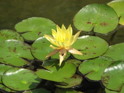
The stumps make it easy to follow the original course of the Goulburn through the lakes. On the map this is not at all clear. Away from the channel, there are shallow areas called backwaters stretching into the distance. The realm of fishermen, but inviting exploration from canoeists. This morning it is the realm of pelicans, swans, moorhens and the yellow water hyacinths, an impressive lilly, a mixture of other garden escapees such as irises, native bulrushes and other wetland vegetation. After Kirwan's bridge the lake narrows and the fishing shacks and holiday homes are are replaced by wheat and sheep farms - a glimpse back in time. The boating zone changes to open water, meaning that waterskiing is permitted. With the number of wake boats and jet skis, this can be cause for concern, however this time the stumps act as protection, providing safe space for canoeists to travel in. Kirwan's Bridge is as interesting to pass under as it is to drive over, the weathered skeletal remains of its original redgum frame have been kept, like decorations, around the more recent structural improvements.
Yellow Water Lily (Aquaplant.tamu.edu) increasingly a problem in waterways of the Murray Darling Basin. A native of Mexico, Yellow waterlilyis increasing an alarming rate in Lake Nagambie and in channels and dams which feed from it, including the billabongs and waterways of the Gunbower Perricoota Koondrook Forest. Once
established it can block waterways and is difficult to eradicate. New growth of this plant is mainly initiated
vegetatively. Stolons are produced during spring to autumn specially following flooding. Stolons produce new
plants at the nodes. (Emerging aquatic weeds in Victoria). All parts of the plant must be removed in order to remove it, or the lake drained and exposed to frost (as was done to lake Mulwala in 2013).
Most banks are covered by trees, but in some places, erosion is faster than the growth of the vegetation which otherwise might protect it. Perhaps an ancient sandhill?
Fishing on Lake Nagambie (Coxy's Big Break).
Old bridge remains linking narrow points of land between the Eastern and Western Backwaters on Lake Nagambie.
Kirwan's Bridge
Kirwan's bridge was closed for some time and a boulder placed at each end to stop traffic driving across it, however there was such an outcry from local and tourists, that funds were found for its repair and maintenance. It was reopened in 2011. ABC News Report on the re-opening of the bridge.
So significant was the access to Nagambie it provided for those living on the west of the Goulburn River that a threat to the bridge’s continuing future in the mid-1950s led to a municipal secession movement that enlarged the Shire of Goulburn at the expense of Kirwans’ original builders, the Shire of Waranga. The current narrowed timber deck with passing bays, supported by rolled steel joists placed over the ancient piers, remains a memorial to that municipal protest. It is one of Victoria’s very oldest timber road bridges still in operation; very few are earlier. Kirwans Bridge is also one of a unique group of four large timber road bridges from the 1890s, of contrasting types, located on the Goulburn River between Seymour and Murchison; this is the last remaining group of large old timber river bridges in Victoria. The 310 metres long Kirwans Bridge is situated over the Goulburn River at Bailieston near Nagambie. It was opened in 1890 and is still in use for one-way motor traffic. The only comparable timber bridge in Victoria in terms of length is the 1927 Barwon Heads Bridge which is 308 metres long. The bridge features a dramatic mid-stream bend and is also unique in its incorporation of two vehicle passing-bays. Source: Victoria for everyone
Celebrating a wedding with photos on Kirwans Bridge. CombiLove
Kirwans Bridge: old and new supports.
Fishing Shacks
Boathouse
The size of trees growing on submerged stumps is limited by the amount of nutrients that can collect in the small amount of room their roots have to grow in: I imagine that birds sitting in their branches would be the main source of these. Grasses and mosses trap and build soil slowly, protecting sensitive roots from the harsh summer sun. Lack of water, would, I assume, not be a problem.
In the early morning and evening light, the lake is serene.
Water mirrors sky, a timeless scene. The Goulburn River Valley once supported a population of
hundreds of members of the Taungurung (Daung wurrung)
Aboriginal people. The country of the Taungurung includes
the area between the upper reaches of the Goulburn
River and its tributaries north of the Dividing Range; from
Kilmore in the west to Mount Beauty in the east, and
Benalla in the north and to the top of the Great Dividing
Range in the south. Evidence of the Taungurung
can be found in many places throughout Taungurung
Country, and includes scar trees, rock shelters, rock art
and place names. For instance, Nagambie or ‘nogamby’
means lagoon. (GMW). I think that the river in its quieter moments, would be a place where they could find peace.
Most trees from the pre-existing river bed are only stumps, yet this one survived over 100 years of inundation. The snags, stumps and trees all provide habitat for waterbirds and turtles.
There are extensive areas of shallow water around Lake Nagambie and the old river course, as well as underwater
objects such as logs and standing trees. Such areas provide valuable
fish habitat, however, they can also obstruct boating and
present safety hazards (GMW). Without much of a current, these are difficult to see, so care needs to be taken when navigating these areas.
At the weir Ruth and I met Paul, one of the Goulburn Murray Water officers. He answered our phone call to their Nagambie office and let us through the locked gate at the back of the compound. The number is not the same as the a number on the sign out the front of the building. When we tried to call for the duty officer, Telstra informed us that the number no longer existed. It turns out that the phone system was changed a few years ago and since the automatic diversion of calls worked for the first year, no-one bothered to change the sign. The correct number is (03) 5794 5900, but in case it changes again, check their web page (http://www.g-mwater.com.au/).
Meeting up with Ruth, I had to push through a bank of reeds.
Looking back into the lake from the boat ramp just in front of the weir.
The path from the boat ramp just before the Goulburn weir: closed to motor boats, but an easy exit point for canoes and kayaks. The track leads straight to the weir car park, where there are very good toilets and plenty of shade and green grass to relax on. To portage around the weir, call Goulburn Murray Water (03) 5794 5900 a couple of days ahead and arrange for the locked gate to be opened and (if you need it) transport for your boat to the ramp below the weir. If you throw your boat over the fence and crawl under, especially in front of their noses (the Nagambie office overlooks the weir), prepare to be yelled at. The gates are locked because of a recent drowning: a tourist was caught in a stopper wave at the base of the weir. We were advised that it is best to call ahead a couple of days beforehand, so that a staff member will be present (they travel all around the district inspecting irrigation infrastructure) and be keeping an eye out for you.
Lazy acres: a simple home, but a fisherman's paradise. Just above the Goulburn Weir.
It must have been a long time ago that the road continued on straight ahead. This sign seems to be stating the obvious, but at night it could well be a life saver.
Sign at the Goulburn Weir showing the water resources managed by Goulburn Murray Water. Not only does the authority manage all of the water resources in the Goulburn Valley, but also all of the dams and rivers on the Victorian side of the Murray. They manage the Hume Dam jointly with NSW water authorities. All up the area managed by the authority is equivalent in size to the state of Tasmania.
The weir wall is open to the public weekdays from 8am to 4pm. If possible, take the time to do walk over the weir to see the segment of original wall at the far end of the weir. The original electricity generation house and electrically mechanism for the gates are still on top of the wall. You will also see how much water is diverted away from the natural river and into the channels, lifeblood for farms, towns and cities further and wide.
Paul said that Goulburn Murray Water prefer canoeists to call them and arrange for a transfer around the weir (they will open the gates and offered to take my kayak on the back of their ute) which only takes five minutes, to half an hour of yelling at them for trespassing. He said that about a month ago a fella was seen throwing his canoe over the two meter fence and then climbing after it. It's much better to call ahead, or at least to knock on the weir office door, both for the boat and for the feelings of the workers at Goulburn Murray Water. Paul suggested that in order to arrange for this service, it is best to call a couple of days ahead to arrange a time - just make sure it is a week day as the office is not manned on weekends. If you do this, they'll be there to help you and the portage will be a much more pleasant experience.
The original cast iron gates, stone base and generator house from 1891 on the Goulburn weir. Some of the gates which were dismantled when the weir was upgraded in 1987 have been transported to and reconstructed at the Australian National Museum in Canberra. GMW General Manager Catchment Services Graeme Hannan, said that two of the original piers, one gate and one section of a walkway have been donated to the Museum (GMW).
Water released as part of an environmental flow into the Lower Goulburn. Plan your trip to coincide with summer irrigation and environmental flows (call GMW to check when these are planned) and you will have more current and less trouble with snags.
Looking back to Lake Nagambie from the section of original weir wall. The cogs and whells are part of the still functioning original weir gate control mechanism.
The gates which block the way to the base of the weir since a drowning some years ago. Call Goulburn Murray Water Nagambie office on (03) 5794 5900 and arrange for assistance weekdays between 8am and 4pm.
"The Goulburn Weir has seen over 1-million visitors and even appeared on the Australian half sovereign and 10 shilling bank note. (GMW).
When the Goulburn Weir was built in 1891, it was the largest water engineering project in Victoria. It was built with sandstone hewn from nearby hills: as you walk over the weir (open weekdays 8am - 4pm) you can see them at the base of the wall. Unlike weirs on the Murray River, which were initially built to improve navigation for river trade by paddle steamers, the Goulburn Weir was built as a water reserve for irrigation. This scheme so excited people of the time, that it was featured on a bank note of the time. No expense was spared with its design. A hydroelectric generator was installed to operate the gates using electricity and lights installed to show off the spillway and weir structure. Special trains were chartered for people to picnic in its grounds and to admire the electric lights at night. Country sports days were held at the weir for many years and on Armistice day, the flags of all the allied nations were flown there. It was a symbol of national pride.
On the left you can see how much water is diverted from the river into the Catternach canal.
Comparison of water levels above and below the Goulburn weir (Lake Nagambie compared to the Lower Goulburn River).
Comparison of water levels above and below the Goulburn weir (Lake Nagambie compared to the Lower Goulburn River).
Three channels leave the weir, providing water for irrigation throughout the lower Goulburn Valley for fruit orchards and dairy production and town water supplies, and, via inter valley channels and the Waranga Basin, contributing to development and water security in the Loddon and Campaspe River systems as well the cities of Bendigo and Ballarat. Usually, only a quarter of the flow from the upper Goulburn is allowed to flow down its original river course, the rest is diverted via channels. Given how seasonal and unreliable our rainfall is in Australia, it would not be possible to grow enough food for our population, let alone export, without such schemes and the visionaries that created them. They do contribute to problems in the Murray Darling Basin, such as salinity caused by over-irrigating, the deteriorating condition of redgum forests, wetlands and the soil in seasonal floodplains by decreasing the frequency and size of floods in those areas. The lack of flow in rivers within the Murray Darling Basin caused the Murray mouth to be blocked for many years and water in the Coorong to be much saltier than the sea. Water birds dependent on these wetlands to feed their young and fuel their global migration began to die out and water quality and security in the lower catchment towns (including the Capital city of South Australia: Adelaide) began to suffer. Community concerns and international obligations to the preservation of wildlife forced the Australian government to act, bringing the three state governments together to agree how to better manage their shared water reserves: and so the Murray Darling Basin Plan was born. The arrogant and ignorant attitude of 'If it flows past my door I can use it and what happens downstream is no concern of mine' was no longer allowed. Catchment Management Authorities now cooperate to ensure that the environment is not forgotten and that water is managed following strategies that benefit the whole basin. On my paddle, this meant that I had an environmental flow, more water than usual was being released, promoting native fish breeding and delivering water downstream at the same time. It also improved the current, making my journey easier.
Waterbird abundance during annual aerial surveys of waterbirds across eastern Australia, 1983–2010
The graph shows changes relative to the long-term mean (dashed line). Some of the long-term changes are related to effects of river regulation, reducing the frequency and extent of flooding on large wetlands systems. For example, wetland extent over this period peaked in 1984, associated with the peak in waterbird numbers. Dept of the Environment: Ecological processes and species populations report 2011.
In the company of a Goulburn Murray Water staff member, we were able to drive down to the boat ramp below the weir. Although you can see three gates open here, in winter, often only one will be.
Walking down to the water. The launch area was protected from the current with plenty of space to get in.
Every portage means unpacking and repacking. Finally ready to go again.
The weir dog knows all :).
Pushing off.
On my way again... but on a dramatically different river.
With normal, rather than dammed levels, beaches appear once again.
Downstream of the Goulburn Weir, the river changes remarkably, the banks are covered in native grasses and the bush looks healthy. All of the vegetation is native; there is no sign of the willows so dominant above the weir. A large male eastern grey kangaroo watched me as I paddled past. The surface of the water was so covered by the ripples left by moving water skaters looking for their insect prey, that it looked like it was raining. The sound of water cascading from the weir behind me ebbs and wanes. Sometimes it is quite loud and I caught myself having to check behind, unable to be sure there really was not a great wave about to engulf me.
The lower Goulburn is the section of the river below Goulburn Weir at Nagambie. The river slows and the banks grow higher. Its colour changes to the green brown of many of Australia's inland rivers. It is no longer the mountain stream that it was above Seymour. It is a though the Goulburn has grown up. Map source: Wikipedia. See also DEPI for information on river conditions.
This section of the Goulburn River is lined with River Red Gums and is an important wildlife corridor linking the mountains of the Great Dividing Range to the Murray River. The picturesque river has narrow strips of vegetation along its meandering banks, with the adjoining River Red Gum forests and woodlands providing a striking contrast to the farmland which was so often a feature along the upper Goulburn. See Park Web
A few kilometres below the weir I came across this remarkable brick water tower, which I believe belongs to a local winery.
The reason why the current is much slower in the Lower Goulburn than in its upper stretches is because the rate of fall is much less: the Goulburn drops most dramatically (300 m) in the first 200 km: in its last 250 km, it only drops around 50 m. Reach report
Remains of an old private wharf or landing upstream of Murchison.
The no longer used Murchison Railway bridge, just upstream of the town.
Murchison road bridge (Goulburn Valley Highway). Approach carefully. I found it virtually blocked by snags. I took the left channel, but had to break my way through. The right channel would have been easier.
There is an elaborate set of steps down to the river from the town, right after the bridge. They were blocked by a tangle of snags when I passed through. They are the only access to town, 12 metres or so above the Goulburn river's summer level. Murchisonvictoria.com.au
Murchison is the first town you pass through after the weir. There is a set of steps leading down into the river by which you can access the town. They were surrounded by snags when I passed through, so landing there is possible, but would be a little tricky. Snags also almost totally blocked the old railway bridge, just upstream of Murchison. The best place to go through is on the right hand side as you going downstream, take another route and you'll experience difficulty. I did, I had to crash through some snags and duck low under a large log. There are many sandbars in the river bends at and following Murchison, which are popular with local fishermen and their families during holiday periods. There are so many though, that finding a campsite is not difficult. As it was a humid day, many people were standing, or sitting with their chairs in the cooling river water. We chatted as i paddled past.
There are many camping sites around Murchison. It was Friday afternoon as I passed through and the weather was hot. Everyone who could be was down at the river. Some had come down to swim, others had set up for the weekend and had just thrown in their first lines, hoping to be able to catch something for the evening meal. I have seldom seen so many good camping sites so close together. i later heard that people come from a long way away to camp here.
I continued on, hoping to make it to Toolamba, but with thunder signalling the threat of an approaching storm, my radio informing me of heavy downpours in the region and tiredness from a long day on the water, I pulled in for the night 4 km upstream from Old Toolamba, at a beach campsite. Tomorrow I will pass through Mooropna and Shepparton and will be accompanied by Barry Bell, a fellow paddler and friend, who drove along the bush tracks and shared a beer with me last night.
My campsite for the night. A spot safe from overhanging trees and where I could easily pull out my boat. The following shots are panoramas of my campsite.
With thunderstorms rolling in, I ate by my boat. It was quicker than taking all the gear up and down and with the wind building, less to blow away. Ruth had brought down a beer for every day I had left - a luxury I have never had before. I was determined to enjoy this one: storm, or no storm!


thanks for sharing such a nice blog.
ReplyDelete