A journal of canoe expeditions along the rivers of Australia's Murray Darling Basin using photographs, stories and information to highlight the beauty, challenges and history of these rivers and the communities they flow through.
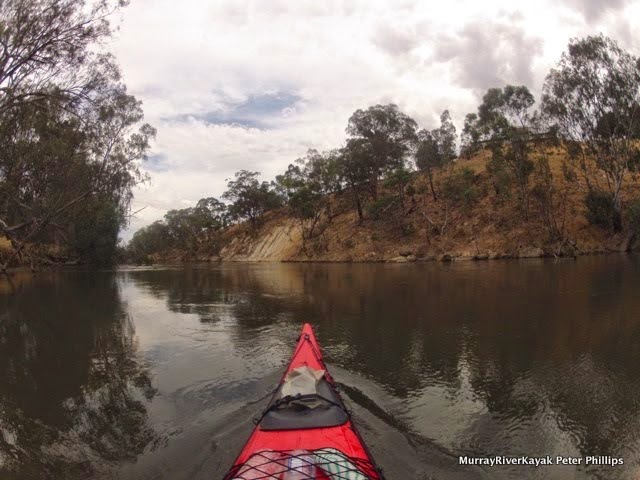
Today I would like to start backwards, for in my books it is hard to beat a cold VB on a deck overlooking the river. Add a cool breeze and the memories of the more difficult parts of the day are washed away. I am sitting at Chinaman's Bridge Cafe, just downstream of the old wooden bridge of the same name waiting for a pub sized parmi. Clouds from the long forecast storm have blocked the heat out of the sun which I have been in all day. Sacred Ground by Goanna is playing on the cafe stereo. The river is full of cockatoos noisily seeking roosting sites. I actually planned a bush camp for tonight, but it's been a big day, almost 70 km on pretty green arms. Severe weather warnings pushed me to look for storm safe camp sites. I thought that Michelton Winery would have been good and pulled in there, but the days when they allowed camping on their lower slopes seem long gone: so I pushed on. I was also keen to get across Lake Nagambie as early as possible the next day. The thought that the weather is usually calmer early in the morning and that most self respecting speedboat owners would still be in bed before 9 am motivated me to get as far as I could today. Eventually I ended up at Lake Nagambie, sipping a cold beer. Sometimes the most memorable things happen when things don't go to plan.
Enjoying a cold beer on the balcony at Chinaman's Bridge Cafe. Lake Nagambie after a long and at times, hot days paddle.
Chinaman's bridge at the entrance to Lake Nagambie.
Tree full of long-billed corellas.
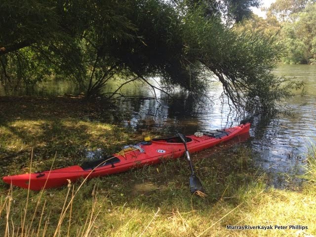
My campsite. After 3 sticky days on the river, I really appreciated the hot showers.
Old farm shed between Michelton and Tahbilk Wineries.
Long billed corellas.
Last night was hot. The mercury barely dropped below 30 and following the thunderstorm the air was humid. Tim thought he might sleep on the verandah of the hut, but the mossies soon convinced him otherwise. A wet towel on our heads and the occasional gentle breeze helped in an otherwise rather sleepless night.
Stocker's hut, where we camped for the night. It had been a humid and sticky night, with very little air movement. It was a relief to get up once the first light of morning light arrived and to get moving again.
From our camp where the river turns west after Trawool we paddled into Seymour around 9:30am.
On the water again, working through the initial stiffness.
The weather was much friendlier than the day before.
There were some fast stretches coming into Seymour, where the river dropped like a big winding escalator. Lots of fun to paddle on.
A fast stretch of water before Seymour.
The first of a series of three bridge crossings at Seymour, two rail bridges for the North Eastern Railway. The first railway bridge is concrete and carries the Sydney to Melbourne line and the branch line to Shepparton. The second bridge is cast iron and carries bike riders on the Goulburn High Country Rail Trail on the last leg of their journey to Seymour. The cast iron bridge was built in 1873, the same year that the rail line from Melbourne reached the Murray River at Wodonga. The line from Sydney joined it at Albury ten years later. Before federation the states could not agree on how far rails should be apart: Victoria decided for broad gauge, NSW for standard gauge and QLD, narrow gauge. Up until 1962 all passengers had to change trains in Albury. Since 1962 standard gauge is used for the entire distance. ref
Tim and I packed early and were on the water at 7:30 am. Our arms had recovered
strength and we managed to set a good pace, arriving in Seymour just after 9:30 where we met Ruth and loaded Tim's boat onto the Echo soon afterwards. I plan to continue on to Echuca, weather permitting.
A look back at the railway bridge as we approach Seymour.
The old road bridge, now derelict.
The landscape in between Trawool and Nagambie is rocky and includes more bush than the last few days. Up until Hughes Creek (24 km from Nagambie) the river alternatively flows through deep pools and then races. One race near Seymour ran through several tight bends, accelerating us up to 16 km/hr for a short while. Other than pressure waves and the odd snag in the middle of the flow there is nothing to watch out for. They can be paddled in an open Canadian canoe. The 20 km after crossing under the Hume Freeway (10 km downstream from Seymour) has gravel races at low water, but at summer levels there were few signs of these. From Hughes Creek the Goulburn comes under the influence of the Goulburn Weir, the water becomes deeper, the levels less variable and the current all but disappears.
Hume and Hovell, during their epic adventure, reached the junction of the Goulburn River & the Dabyminga Creek on 23rd December 1824. In those days the Goulburn was known as the Hovell and the Dabyminga as Reedy Creek. Hume’s mare was bitten by a snake so they decided to camp for a few days at the foot of a hill now known as Camp Hill, allowing time for the horse to recover.
Hume’s edited account runs as follows: “From the top of the hill we obtained a fine view of the river flowing from the north east through a gap in the mountain range distant about eight to ten miles where after a considerable curve to the west it eventually turned north west in which direction it was visible at a great distance” . Hume & Hovell observed Christmas Day at their camp “to avail themselves of the fine fish which abounded in the river”. On Boxing Day, Hume’s mare had now recovered from the snake bite and they crossed the river at a ford slightly to the north of the junction of the Goulburn and Dabyminga Rivers. It was this journey, which opened up Victoria and inspired explorers such as Hawdon, Gardiner and Hepburn (who became known as the ‘Overlanders’) to travel to the region. They reached the area in 1836. Hawdon was so impressed with the area that he took up 27,520 acres which was known as ‘Tallarook Run’. Tallarook Mechanics Institute.
Hawdon took sheep to Melbourne when that settlement consisted of only a few slab huts to test the viability of driving stock from NSW to the South Australia, which in 1837 was threatened with famine. Prior to this time stock had been shipped from Tasmania, or South Africa. The trip was seen as foolhardy, but following the Murray, Hawdon found that despite the heat, the cattle fattened on the reeds growing alongside the rivers. Within two years of their arrival, the first herd of 480 cattle had increased threefold (ref).
Tallarook means 'the call of the wattle birds' in the language of the Goulburn aborigines. The town was founded in 1860 on land from Joseph Hawdon's run. Joseph Hawdon was one of the original overlanders who, on hearing explorer Thomas Mitchell's reports of the rich, tall grasslands of the riverine plains, decided to follow the explorer's route, staking a claim in the area (Tallarook Mechanics Institute) which he called the Tallarook Run. As an overlander, he drove stock first to Melbourne and later to Adelaide. In 1872, the North-Eastern Line pushed through the town and onto Molesworth, provided more employment and helped develop the timber industry supplying firewood to Melbourne. In 1890, the population of the town rose to 200 (Mitchell Shire historical documents). Today the population is around 800 (ref). Visiting the town is like a step back in time, with many of the original buildings preserved much as they were when they were built over a hundred years ago. As an interesting aside, the granite from the hills through which the Goulburn winds in this area was used in the building of Flinders Street Station (ref).
In Seymour, the Goulburn River Caravan Park has a public boat ramp, from which it is only a short walk into town. The caravan park is just before the railway bridge. There is another boat ramp at the well maintained Lions Park, about 1 km downstream from the old bridge. In the old days, Seymour was known as the New Crossing Place, after the Mitchell's crossing near Mitchelton was abandoned in favour of Hume and Hovell's at Seymour. This became the place of choice to take stock across the Goulburn River on the route between Melbourne and Sydney. As traffic increased so did the infrastructure developed to take it: both the Sydney to Melbourne Railway and the Hume freeway still cross the Goulburn at, or near this point.
The New Crossing Place and Lions Park information sign, telling a little of the history of the town.
On my own again after Ruth picked up Tim.
Our dog Harry trying the boat out for size. Despite the brave look, it wasn't really his thing.
Remains of the old wharf in Seymour. Before the Goulburn weir blocked the River at Nagambie, paddle steamers made it as far up the Goulburn as Seymour.
The first Emily Jane paddle steamer was designed specifically to service trade on the Goulburn River from Echuca to Seymour. She was built at Wyuna in Thomas Buzza’s saw mill and boat building yard in partnership with Charles Wordsworth and William Rose, to the design of T. Price of Echuca. Murchison Historical Society.
Hume freeway bridge about 10km downstream from Seymour.
Flocks of corellas, more of a lower river bird than the Sulfur crested cockatoo.
We saw our first corella today, it sat a most a group of cockatoos, as if hoping to be included. Closer to Nagambie there were flocks of them. I also startled some sheep and cows, not deliberately, it happens when I drift silently around a corner. I had fun photographing a sheep as it realised there was a big red thing in front of it that wasn't there when it put its head down to drink and was a few seconds later and had to decide what to do.
Round Seymour real estate became more elaborate and expensive. The 20 km after Seymour has limited access, great views and is only a stone's throw from Melbourne.
The height of the pump house indicates how high the river rises in floods. Farmers are forever seeking ways to stop their expensive electrical pumps from being ruined by flood waters. This one was on a solid looking concrete block.
Nice looking camping spot and shelter.
A surprised sheep.
Beginning in Trawool, but concentrating around Seymour and in the areas of the Goulburn near Nagambie were elaborate properties and houses. Most were two stories and architect designed. In Trawool they ran sheep, in Seymour horse and near Nagambie, cultured wine. Scattered amongst them are the remains of original fishing shacks and camp shelters, good places to go to when lightning is an issue.
Michelton winery and Tabilk winery are a real pleasure to go to. Michelton has its iconic tower with an observation deck up high which you can catch a lift to for free. There are excellent views of the stretches of the Goulburn you have just paddled, restaurants and an impressive pergola. Michelton is also the site of the first crossing of the Goulburn by settlers on the overland trail from Sydney. There is a plaque in Michelton which reads...
"The old crossing place marks the point where the majors line from Portland Bay crosses the Goulburn River and where the first citizens of Victoria, overland era from New South Wales to the new district of Australia Felix, forded their stock and property, just below Mr. Clarke's Inn. The old crossing place became known as such after a new crossing place was established in late 1830 a few miles upstream from Michellstown at what later became known as Seymour."
Mitchelton's 55 metre tower was designed by renowned Australian architect Ted Ashton.
On their website, Michelton Winery acknowledge the importance of the Goulburn in developing the unique taste of their wines and a sustainable land management style which respects and cares for the environment that nourishes it.
Seasonal tributaries, shifting flood-lines and receding watercourses have stamped their presence on the landscape of Mitchelton. The ancestral courses that ebbed and flowed across the property over the last two hundred thousand years have resulted in a complex matrix of soil types that in turn nourish unique and distinct qualities in the vines that prosper on individual blocks.
The Environment: Mitchelton Estate’s influential and ever-present neighbour, the Goulburn River demands a holistic winery and vineyard approach. Banked by red gums and widening into billabongs, the river is an intrinsic part of a sensitive natural cycle. The Mitchelton team are dedicated to managing their entrusted backyard as custodians of a sustainable and distinct eco-system.
Michelton Winery: https://mitchelton.com.au/
The river between Michelton and Tahbilk. Note that the river is closer to the top of its banks as it nears Goulburn weir.
Some straights stretch for several kilometres. Just before Tahbilk I passed through a dedicated water skiing zone. Whilst river traffic was controlled and disciplined in these areas, there were quite a few boats and jet skis which did not obey the speed restrictions either side. It is a good thing the river is wide and that there is plenty of room for everyone.
Just before Lake Nagambie is Tabilk winery, established in 1860, it is the oldest in Victoria. It boasts a wharf, many original buildings, a restaurant and a wetland Eco trail - all of which are worth a look. Tahbilk sits between the Goulburn River and a billabong. Tahbilk have built 4 kilometres of walking tracks, run eco-cruise tours through the billabong's wetlands and have a café with bushland views. The Purbrick family, which has run Tahbilk for five generations, is committed to maintaining the environmental and cultural connections that make this area one of the premier wine growing regions in Victoria.
"The fabric of Tahbilk, its buildings, its estate vineyards, its 1860 shiraz block, and its idyllic setting by the Goulburn River (and its anabranches) all have history so seamlessly woven through its fabric that it's become timeless. Nothing will be changed or added in the future unless it is part of the continuity stretching back to 1860." Tahbilk: Our Story.
"Your first sight should be the 1860 Shiraz vines. They are a thing of beauty, diminished in number due to age, but still productive and found alongside the dirt road into the property." - AUSTRALIAN GOURMET TRAVELLER WINE
Erosion on an outside bend of the river approaching Lake Nagambie. The rest of the fence has disappeared. In some parts of our inland rivers banks have changed little since white settlement; in others banks are visibly crumbling. Action by authorities to reduce the speed of erosion is happening, but seems to concentrate on a limited number of areas.
Original farmhouse, just upstream from Lake Nagambie.
Old farm shed.
Chinaman's bridge at the entrance to Lake Nagambie.
Chinaman's bridge was constructed in 1891 and at the time known as Kerris Bridge, the bridge included a lift span to enable sawmill and recreation steamers to continue to utilise the Goulburn River. It carried the Nagambie-Heathcote Road, originally known as Chinaman's Road because of the number of Chinese market gardens in the area at the time. The timbers are hand hewn and it is one of the earliest timber bridges in Victoria. The draw bridge was replaced in 1940 with a steel span. (Victorian Heritage Database).
Chinaman's bridge. Still in use.
Chinaman's bridge caravan park.
My camping site at Chinaman's bridge caravan park. Very clean, great facilities, but not cheap.
In contrast to the deep areas of the Goulburn upstream of Seymour, there are wake boats and jet skies everywhere here. They do laps in the their favourite areas, putting up large wash in the process. It doesn't seem to matter where in the river you paddle the waves seem to get to you.
The caravan park I am staying in is full of the sound of children. They roam freely around the park, on bikes, on foot, or at the basketball courts, with family, friends, or as a group of similarly aged kids who have found each other. They are happy noises. It seems like an excellent family holiday - particularly if you like water sports.
It is drizzling tonight and with the promise of a good nights sleep, I will leave this blog for the day. Hope it makes sense, I kept falling asleep whilst writing it. Perhaps it was those beers on the balcony.
Molesworth to Killingworth (57 - 76 km from Eildon).
Molesworth Caravan Park.
The Molesworth township is set about 500m back from the river flats. All the old river towns did this as a protection from flooding. Today many councils allow building much closer to the water: a recipe for trouble. Molesworth has been affected several times by flooding of the Goulburn River. Various bridges were damaged or washed away, and severe floods occurred in 1870 and 1934. (ref)
Outdoor dunny... having survived the floods of 1934, it is now a garden shed... The construction of the Eildon Dam reduced the risk of floods, and the connection of the town to the State Electricity grid brought electric refrigerators in pace of kerosene units. (ref)
Molesworth was named at the same time as Yea (1855) by a Government surveyor, probably after Lieutenant J. Molesworth, a casualty in the Crimean War about five months before. Molesworth had been a colleague of the Victorian Surveyor-General, Andrew Clarke, in the 7th Royal Fusiliers (see also the naming of Yea). An alternative version is that it was named after Sir William Molesworth, (1810-1855) Chairman of the Transportation Committee which recommended abolition of the transportation of convicts to New South Wales.
The first settler at Molesworth, John Sloan, built an inn and operated a punt across the Goulburn River for travellers to and from the Upper Goulburn goldfields. Moleswoth's beginning is generally calculated form Sloan's settlement in 1859. The township was surveyed in 1864 and a store with a post office was there by 1875. The primary school was opened in 1880. The railway was extended from Yea to Molesworth in 1889, at about the time a sawmill and a butcher were added to the township. Ten years later the Anglican church was opened. (ref)
Watching the sunset from the pub with a $10 parmi... there could be worse things.
Letting out your inner freak... at the New Year's Eve party.
Waking up with the gentle light before sunrise, I decided to have a look around Molesworth. From the caravan park, town was a 300m walk up to the higher ground to the South of the river. As with many small country towns, the caravan park was larger both in populace and size than the town itself. Set either side of the Goulburn Valley Highway, Molesworth appeared both functional and liveable. The town hall still sported the last piece of Christmas decorations, in the form of tinsel strung above its entrance door, the corner store advertised locally made sheepskin products and the pub used placards to let people know about its $10 parmies and an up and coming Eagles revival night. In places like these, the pub functions like a community centre and the bar staff, informal councillors.
Molesworth grew and identified with the railway which linked the town with its neighbours from the early 1889 till 1979. The construction of this line involved the building of a 220 metre tunnel. The Goulburn River High Country Rail Trail follows this track. Riders pass through the brick lined tunnel under McLoughlin's Gap between Cheviot and Molesworth. Although built during the Goulburn gold rush, it busiest times were between 1900's to the 1930's transporting timber to saw mills. From 1940 road replaced rail as preferred method of transport. Up until its closure in 1979 the railway supported local farms; there were even exhibition trains on good farming practise. Once the rail closed, other key services followed, with the primary school closing the next year. The rail trail, caravan park and pub now lead the way in a tourism based revival for the town. They all benefit from a healthy and beautiful Goulburn River. (ref 1, 2, 3).
By 8 am we were packed and on the water. We had seen the dark shape of the river moving silently and swiftly pass us during the evening. On a journey such as this, where we are riding a river through the landscape, getting off feels like losing ground. Goulburn Murray Water estimate that it takes 10 days for the water released from Eildon to reach the Murray River. Every hour that we spent off it meant more catching up the next day to truly follow that flow. As we allowed the current to catch the bows of our boats and point us downstream, it felt right, we were on our way again.
We followed the flow for 57 km (exactly the same distance as the day before), which brought us to a point 5 km downstream from Trawool. Feeling the heat from the day before, we slowed our pace a little. The river is impervious to human feelings and thoughts, it just is. It is a physical entity that follows the laws of nature, the predominant one being gravity. It continually searches for the quickest way down. Gravity is what powers the short cuts through the willows, eventually uprooting trees and forming the shallow fast streams that will eventually form the new river bed. In places the river visibly descends down drops which can be felt as you paddle over them. Occasionally these drops continue for kilometres, the speed of the current picks up and the water swirls and swells with current bubbles, small whirlpools and pressure waves. Teaming up with momentum, the faster current on the outside of the bends causes the river to bank like a kid running through the backyard pretending they can fly, scouring at the soil, collapsing the banks and bringing down mighty trees in the process.
The first ten kilometres after Molesworth has a montane feel to it. The river winds its way through tall mountain ash. we saw red headed gang gangs (a mountain member of the cockatoo family) and currawongs, both of which are associated with high altitude areas.
For the first 10 km after Molesworth, the river was flanked by tall and majestic mountain ash, with their distinctive ribbons of bark hanging from candle like trunks. Usually found at a much higher altitude, they give the Goulburn the feeling of being a mountain stream. Currawongs, gang gangs and bell birds (all mountain birds) added to the illusion that we were indeed much more isolated than we actually were.
Mountain ash only occur in cool areas of very high rainfall. This is usually the mountains, but Molesworth's climate seems to fit the bill. Source of graphic: Wikipedia
As the river raced around its bends it brought down some of these giants. Snags replace the rocky river bed of yesterday, the banks become sandier and the river changes from its dark translucent brown colour to the clear green that could be found in the middle sections of the Murray before carp and population pressure changed it. The banks become steeper, with up to two metres of sediment in places. Occasionally the hills which define the valley that the river flows through, run dramatically, straight into the river. In these places, native vegetation has been able to hold its own against the willows and one gets a glimpse at what the landscape would have looked like before Europeans arrived, with tea tree and melaleuca bushes reaching right down to the water's edge.
Killingworth to Ghin Ghin (76 - 83 km from Eildon).
At Killingworth, we passed by the pumping station for the North South Pipeline. It is almost undetectable from the water's edge. There is no large pipe to be seen; it is all deep underwater. Only a rock wall, warning signs about a submerged object and the house-like pumping station betray its presence: remarkably little fanfare for such a controversial piece of engineering.
The North South Pipeline during its construction in March 2010. In an article from that time, opposition parties said that the pipeline was taking water from already stressed river systems. (ABC TV)
This pipeline takes water released from Eildon which can then be pumped into Melbourne’s water supply catchment should that cities water reserves fail. Melbourne's can store around 1,810 GL in its reserves. In 2008, just before the last drought broke, the cities reserves reached a worrying low level (600 GL). The government embarked on two ambitious projects: the first was this pipeline and the second was a desalination plant. Both were politically contentious because of their cost and because of the environmental and social effects of the projects. Realistically, the government had no other short term alternatives. Wastewater recycling was decided on as the long term strategy of choice, but in the short term there was no other choice: Victoria would struggle to cope with the millions of environmental refugees should Melbourne run out of water.
Salt water worms swum upstream and colonised freshwater turtle shells in the 2000 drought http://www.australiangeographic.com.au/topics/science-environment/2009/07/gallery-working-on-the-murray-river
The Sugarloaf Pipeline effectively ‘drought-proofs’ the city by linking it to the largest store of freshwater in Victoria (Eildon dam holds 3,334 GL when full). The problem was, that the low levels in Melbourne's water reserves also existed in the rivers of the Murray Darling Basin. Salinity was so high in the Coorong that it 3 times saltier than the sea. In Goolwa, the Australian Geographic photographed school kids chipping away salt water tube worms from freshwater turtles shells so that they could swim. In the Lower Murray, acid sulfate soils poisoned waterholes and threatened to do the same with water flowing downstream. Steve Posselt (Cry me a river) left the Goulburn here and walked overland to Melbourne to highlight the plight of Australia’s inland rivers in 2008. I accompanied him as he paddled upstream from Echuca to the Goulburn junction. The Goulburn river was so low the year when he paddled up it that he often had to walk, or pull his way through tangles of snags.
Steve Posselt's Classic Trek in 2009 to highlight the plight of inland rivers. In 2009 Steve paddled up the Goulburn to Killingworth and then pulled his boat overland till Melbourne. Kayak4earth.com Watch on Youtube.
Lunch break in the shade of some obliging willows.
We saw many flocks of sulfur crested cockatoos today. Enjoying the tall trees either side of the river, their sentries would sound alarm as soon as we came into sight and sent the whole group in drive and drabs chaotically screeching and weaving through the bush. We saw few of the birds of prey, common along the drier stretches of Australia's inland rivers and no kangaroos. Near the end of the day we did see one rock wallaby. It puzzled us as to why there should be so few. Platypus appear to do well in the cold mountain water of the Goulburn. They surfaced just in front of our boats, quickly diving once they realised that they were not alone. There would be many more that we did not see.
2 km North of the Ghin Ghin bridge is the former township and goldfield of Ghin Ghin. Alluvial gold can still be found here. During the gold rush, there was active mining at Red Line Reef, City of Melbourne Reef (1, 2 &3), Providence Reef and McLeish’s Reef. More info on the mines and gold mining in Victoria can be found at Mines Victoria’s website (link).
The inhabitants of Ghin Ghin complain bitterly that notwithstanding the large population of the district, and the large amount they contribute to the general revenue in the shape of publicans' and business licences, etc, they have, nevertheless, no police protection. A memorial on the subject was some time ago forwarded to the proper authorities; the only reply received was to the effect that the place was not of sufficient importance to warrant the stationing of a constable at Ghin Ghin, but that one of those worthy functionaries would be occasionally sent to visit the place. We fully appreciate the moral effect of the presence of one of those dignitaries of the law; but we very much question whether a fortnightly visit will have sufficient influence in preventing drunken brawls and breaking of heads, which occasionally take place in the midst of such a large population as there is assembled at Ghin Ghin. Alexandra Times1868 (Trove).
Elaborate houses overlooking the Goulburn became more common as we approached Seymour.
Downstream of the Ghin Ghin Bridge, the river becomes shallower and wider. Willows dominate the shoreline once again and colonise the shallows leading to the development of treed islands and a mess of indistinct channels. River management authorities, blame willows for exacerbating the damage caused to the river banks during flooding. Able to grow and establish in quite strong currents, they essentially block the river, forcing it to go around them, creating a maze of channels which widens the river bed. Canoeing down the river, it is sometimes difficult to pick where the main channel is and impossible to be sure whether the passage will be safe. 5 km down from Ghin Ghin Bridge we had to ask local fishermen which was the best way to go. If there is no-one to ask, the channel with the most current (or the widest channel) is usually the safest.
Trawool to camp 5 km after the bridge reserve (107 - 114 km).
Approaching Trawool, there are some deep slow reaches where large rounded boulders line and dot the river. They are a stark contrast to what we have seen so far and quite photogenic. I can imagine that they would look beautiful in the soft morning light, or a winter fog.
The boulders.
Trawool has the Grand Old Hotel, a resort. The town is set about 250 m back from the river. It sports beautiful views over the Goulburn’s still young and narrow valley. Much of the land appears to have been cleared for cattle and sheep grazing. Access to Trawool is poor, consisting of a steep boat ramp underneath the Goulburn Valley Highway bridge. The only camping opportunity I saw was next to this boat ramp, but it would have been very noisy. We considered walking up to the resort to take a look, but with access so poor and no safe place to leave the boats, we decided to push on.
Trawool Resort: http://www.trawoolresort.com.au/
Downstream from Trawool the landscape appears like a Streeton painting.
It was now late in the afternoon, clouds indicated that thunderstorms were building. We began to look for a place to stay in earnest. This is not always an easy thing given that, especially in these conditions, it is important to avoid tall trees and overhanging branches. We sighted a makeshift jetty and fisherman's shack with a clear area where we could set up our tent and pulled in. The idea being that if the thunderstorm became severe, we could shelter under the hut's verandah. All of which we did, with the permission of the owners (John and Jo Stocker: now wine-growers, but formerly head of the CSIRO and advisor to John Howard on matters of scientific policy) who turned up a few minutes after we had arrived. Read more about this impressive man's contribution to Australian Science here. It was a great finish to the day, watching the rain fall, sitting on deck chairs under the protection of its old verandah, the river flowing gently by and the bush stretching into the surrounding hills.
What to do when a thunderstorm approaches when canoeing.
Keep up to date with weather forecasts, either online, or using an AM radio. Plan ahead for a safe exit.
Learn how to read the weather: tall cumulonimbus clouds are signs of a building storm. Alter your plans to allow for a safe exit.
If you can see lightening, or hear thunder, then it is time to seek shelter.
The best shelters are solid buildings with electrical cabling, or cars (because they are earthed).
Avoid tall trees, clear areas and tall poles. Seek low bushy trees of even height.
If there is no shelter, crouch on the ground on top of your lifejacket (it is an insulator) and protect your head.
If caught on the water, secure your paddle and lie down forwards on your boat.
For more information: 1, 2, 3, 4, 5,6, 7, 8, 9, 10
We sighted a makeshift jetty and fisherman's shack with a clear area where we could set up our tent and pulled in.
Thanks to John and Jo Stocker for permission to shelter at their idyllic hut. We had no idea at the time the important role this modest man had and still played in the development of Science in Australia - including the invention of Wireless LAN read about it here.
John and Jo Stocker, established a vineyard in 1987 on the sunny foothills of the Tallarook Ranges, after having developed an interest in viticulture in Switzerland. They named it 'Brave Goose' after a goose who protected the vines from marauding cockatoos and survived numerous fox attacks. The winery is managed by their daughter, Nina and her husband John. Brave Goose Winery. Facebook.
Brave Goose Winery patrons.
Relaxing on the veranda, sheltered from the rain.
After the storm had passed, the air was so humid and still that it formed a metre thick layer of cloud above the river at about the height of the bank. Tim thought he might sleep on the veranda, but the mossies soon convinced him otherwise and he joined me in the tent, where we spent the first half of the night staying as still as we could, savouring each and every breath of air which might venture into the tent to cool us down.


