Monday: 19/11
Torrumbarry - Lock 26 - Bush campsite 20 km below weir.
River markers: 1668 to 1608 km to the sea.
Distance travelled today: 60 km
Total distance travelled: 104 km.
On this day journey I saw massive changes in the Murray River. My camp was 46 kilometres downstream from Echuca. The banks were still high and there was farmland on the NSW side of the river. As I came closer to Torrumbarry Weir, the river banks seemed to get lower and lower -really it was the river that was rising, held up by the weir, number 26 of 13 with locks allowing boat traffic to pass through (14 to 25 were never built). The bush became lusher and billabongs more frequent. Cockatoos seemed to be in heaven here. Although not the numbers I remember from my childhood, those that I did see almost seemed to be playing. Whether it was how they came down to the water to drink, often hiding behind logs and then lifting the heads and raising their crest to take another look at this big red boat going past, suddenly unsure, or pulling bits of wood off soft rotting logs on the forest floor, curious as to what they might find. In the last kilometers before the weir, where the river bends are so convoluted that it is possible to see the river coming back on itself only a stones throw away, the banks are almost at water level.

The downside to all this beauty is that for the last 30 kilometres before the weir the current is as good as dead. It is hard paddling. You know that if you stop, well you stop. No free kilometers from the river here and if there is a head wind, you’ll go backwards. To take the focus off the current I skirted the tall reeds lining the sides of the river. These were pretty, full of unseen little birds and something I was not used to coming from Echuca.


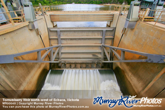
You can hear the weir before you see it. Approaching it in my kayak I had the feeling that I was coming up to a waterfall - which is exactly what it is - only a man made one. Generally, boats and sane people don't go over water falls. I had to tell myself to keep calm and approach the lock. The lock was designed to allow safe passage for river boats whatever the level of the river and although built at the dying end of the river trade there had been dreams of a river transport network to rival road and rail as still exists in Europe and the USA.
Torrumbarry - Lock 26 - Bush campsite 20 km below weir.
River markers: 1668 to 1608 km to the sea.
Distance travelled today: 60 km
Total distance travelled: 104 km.
With locks and weirs and paddleboats
they hoped to make life grand
a little bit of the old world
here in New Holland.
Instead of flies and heat and shadeless trees
they greened the landscape,
built crops and shops,
income security.
they hoped to make life grand
a little bit of the old world
here in New Holland.
Instead of flies and heat and shadeless trees
they greened the landscape,
built crops and shops,
income security.
With hindsight critic comes easily,
but on the back we ride,
of those brave souls,
our pioneers -
but would we have their hide?
but would we have their hide?
The cheek to change not just a creek,
but a flooding river 5 miles wide.
What would we do when rains did fail
What would we do when rains did fail
and stock all round us died,
when struggling to feed our families,
and a newborn nation's pride?
The dream,
inland river highways,
inland river highways,
is past and not to be.
Irrigation used the water up:
the river never reached the sea.
When this old river thrives,
when eagles, cod and mayflies breed,
when wetlands flourish and birds once more fill the skies,
when we can drink the water and let our children swim,
when all can share and show respect
then our souls can rest
they can be free,
when all can share and show respect
then our souls can rest
they can be free,
for the river will have retained
its majesty.
30/3/2014
its majesty.
30/3/2014
 |
| Kingfishers are hard to photograph without a zoom lens! |
On this day journey I saw massive changes in the Murray River. My camp was 46 kilometres downstream from Echuca. The banks were still high and there was farmland on the NSW side of the river. As I came closer to Torrumbarry Weir, the river banks seemed to get lower and lower -really it was the river that was rising, held up by the weir, number 26 of 13 with locks allowing boat traffic to pass through (14 to 25 were never built). The bush became lusher and billabongs more frequent. Cockatoos seemed to be in heaven here. Although not the numbers I remember from my childhood, those that I did see almost seemed to be playing. Whether it was how they came down to the water to drink, often hiding behind logs and then lifting the heads and raising their crest to take another look at this big red boat going past, suddenly unsure, or pulling bits of wood off soft rotting logs on the forest floor, curious as to what they might find. In the last kilometers before the weir, where the river bends are so convoluted that it is possible to see the river coming back on itself only a stones throw away, the banks are almost at water level.
The downside to all this beauty is that for the last 30 kilometres before the weir the current is as good as dead. It is hard paddling. You know that if you stop, well you stop. No free kilometers from the river here and if there is a head wind, you’ll go backwards. To take the focus off the current I skirted the tall reeds lining the sides of the river. These were pretty, full of unseen little birds and something I was not used to coming from Echuca.
 |
| Just above Torrumbarry Weir there is a strange collection of old buses and vans... 70's again? |
 |
| Above the weir the banks grow lower and lower, until it feels as though even the smallest wave will break out of the river and flow through the forest. The current is as good as non-existent. |
 |
| Approaching Torrumbarry weir. |
The lock master Alan Williams, opened the gates just wide enough for my boat to squeeze through. I ducked to fit under the walkway (which is raised for larger vessels) and positioned myself in the middle where he assured me that I would experience the least suction from the 'plughole' at the other end and best ride out the waves that form when the water gets low. The plughole was an apt description. The whole thing is gravity fed, there are no pumps involved. Water is allowed in from above the weir to bring the water level up and drained through gates in the wall at the bottom end to lower it. You don't want to be too close either. I felt part of history, part of someone's dream of Australia that never was - and very small in that big lock. It was a privilege and an experience I can really recommend.
As I passed through the swirling water of the lower gates I was in the real Murray again. It was deeper and narrower than at Echuca and in contrast to upstream of the weir, the river banks were bare and caked in dry mud from the recent high rivers. The constant high river level upstream of Torrumbarry allow vegetation to colonise the banks, right down to the waters edge. Here the banks were eight metres tall, steep and barren. It took some getting used to. The river also seemed to take a while to settle, to work out where it's current should flow and to drop the mud picked up from the base of the weir and form beaches again.
This steeply banked river runs between the Barham Perricoota Koondrook forests. It is a natural and cultural icon, much loved and contested by people of many different interests and one of the most isolated stretches of the river in its whole course. It's many snags and clay bars make it unsuitable for the water skiing so popular above the weir, but God's gift to fishermen. Sitting on the high bank where I pitched my tent I have never seen so many fish swimming through the water, checking out areas where the water swells and behind logs for anything tasty. The banks may be barren, but the water is full of life... and clear.


Instead of opening the rivers up to round the year river trade, the weir enabled the development of land along the Victorian side to intensive farming through a system a delivery channels. These channels linked previous river courses, existing streams and billabongs, building a network that could deliver water on demand to 1000's and 1000's of farms. They effectively created an inland delta. People found that with more water, they could farm intensively. Dairy farms became popular and the area attracted new settlers. Small towns found that with roads and water, they did not need to be linked to the river, nor depend on its ebbs and flows and grew. Torrumbarry, Cohuna, Leitchville, and Kerang developed into proud communities.


It is surprising the range of fish that Alan finds passing through the fish ladder at the weir: occasionally he even finds a rainbow trout - but only in the cooler months. He says that the murray cod numbers have not really dropped despite the black water event of 2011 when many large fish were seen floating down the river. he thinks that where it was possible for the fish to swim up tributaries like the Campaspe and Goulburn, then they were able to escape the low oxygen water and re-populate the river.

As I passed through the swirling water of the lower gates I was in the real Murray again. It was deeper and narrower than at Echuca and in contrast to upstream of the weir, the river banks were bare and caked in dry mud from the recent high rivers. The constant high river level upstream of Torrumbarry allow vegetation to colonise the banks, right down to the waters edge. Here the banks were eight metres tall, steep and barren. It took some getting used to. The river also seemed to take a while to settle, to work out where it's current should flow and to drop the mud picked up from the base of the weir and form beaches again.
 |
| Going through the lock at Torrumbarry is a bumpy ride. I felt pretty small in a kayak. The weir master said to keep away from the other end because that is where the plug hole is. "Don't want you sucked in there". Turns out he was not kidding. |
 |
| Going through the lock at Torrumbarry is a bumpy ride. I felt pretty small in a kayak. The weir master said to keep away from the other end because that is where the plug hole is. "Don't want you sucked in there". Turns out he was not kidding. |
 |
| Without the weir, the river returns to its natural height for this time of the year. |
 |
| Downstream from the weir it is shallow and snaggy. |
 |
| Wharf remains. |
 |
| The river downstream of Torrumbarry Weir until Murrabit is deep forest, the Holmes Glenn of river red gum forests. |
 |
| Day 2 camp. |
More about Torrumbarry Weir
History
LOCKING THE MURRAY. TORRUMBARRY WORKS BEGUN. 'Part of -£5,000,000 Scheme.' (BY OUR SPECIAL REPORTER.) About 24 miles from Echuca by road, and between 40 and 50 miles following the devious downstream course of the Murray there is a U-shaped bend in the river that is a mile around but only an eighth of a mile in width at the neck. Across this narrow neck a new channel is to be excavated so that the river can be diverted and the U bend "cut out." Within the new channel a lock and weir are to be constructed and they will be the most easterly of the great chain of river works,that will make the Murray navigable for 1,000 miles of its course. The turning of the first sod in connection with the Victorian -New South Wales section of this undertaking on Saturday by Mr. Gloom, Commonwealth Minister for Works and chairman of the Murray River Commission, was made the occasion of an interesting ceremony that was joyfully celebrated by residents,and marked a definite stage in the development of a great project. There are to be 26 locks and weirs on the Murray and nine on the Murrumbidgee. Those on the Murray will be roughly 40 miles apart. Primarily the locks and weirs are to secure a navigable river but they are also an important step in the conservation of the waters that for so many years have been allowed to run to waste. The Torrumbarry Works will bank up sufficient water to give a depth of 6ft at Echuca. They will also make it possible to fill the Gunbower irrigation channel by gravitation, and so keep the Kow Swamp Reservoir supplied, and, in addition, will save the pumping into that channel for Cohuna. To lrrigationists in Victoria and New South Wales however, the chief advantage from the liver works which the Murray River Commission is constructing will be conferred by the great reservoir at the junction of the Mitta Mitta. The work is to begin almost immediately. |
|

 |
| Campaspe Loddon Irrigation Area; MDBA source: |
Instead of opening the rivers up to round the year river trade, the weir enabled the development of land along the Victorian side to intensive farming through a system a delivery channels. These channels linked previous river courses, existing streams and billabongs, building a network that could deliver water on demand to 1000's and 1000's of farms. They effectively created an inland delta. People found that with more water, they could farm intensively. Dairy farms became popular and the area attracted new settlers. Small towns found that with roads and water, they did not need to be linked to the river, nor depend on its ebbs and flows and grew. Torrumbarry, Cohuna, Leitchville, and Kerang developed into proud communities.
The old weir was built in 1923 at a place where the river looped. It was made of a red gum planks resting on a steel framed trellis, which could be pulled into the river, or back out of it for repair on a set of railway tracks set into concrete in the bed of the river. It is hard to see how such a structure could hold back the force of water backed up for 100 kilometres (all the way to the Goulburn junction 18 kilometres above Echuca) but it did. These wooden planks were moved by hand, using a long pole. The structure was freed from snags in the same way.


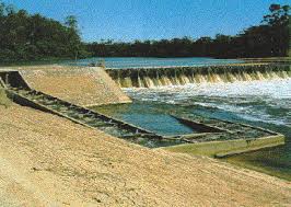
Old Torrumbarry Weir:

The old trestle weir was replaced in 1992 after the river found a way beneath the concrete foundations and large whirlpools began forming in front of the weir wall. The new weir is based on German design and includes hydraulically liftable gates and systems for removing snags which have washed up against the weir without requiring people to climb down to the snag, as with the old weir. Talking to the old weir masters who were around at the time of the original weir, they said, "we didn't think too much about it, it was just what we did. I don't recall anyone ever being injured." All the same, I don't think standing in the water, balancing on a slippery weir face and operating a chainsaw with one hand would pass as safe practise these days.

| Old Torrumbarry Weir: |
The old trestle weir was replaced in 1992 after the river found a way beneath the concrete foundations and large whirlpools began forming in front of the weir wall. The new weir is based on German design and includes hydraulically liftable gates and systems for removing snags which have washed up against the weir without requiring people to climb down to the snag, as with the old weir. Talking to the old weir masters who were around at the time of the original weir, they said, "we didn't think too much about it, it was just what we did. I don't recall anyone ever being injured." All the same, I don't think standing in the water, balancing on a slippery weir face and operating a chainsaw with one hand would pass as safe practise these days.
The weir today
 |
| In 2010 all gates were lifted up to all the river to flow freely and prevent unnecessary flooding. |
Frustrated with the amount of carp in the Murray, lockmaster Alan Williams invented a fish cage which only trapped that pest species. Now in its fifth version and on fish ladders at weirs along the Murray, the cage takes advantage of the tendency of carp to jump when they meet a barrier and of native fish to dive. The native fish find a passage out of the trap when they dive, whereas the carp find themselves in a big steel cage. When carp were at their worst, Alan was pulling out the cage three times a day, a tonne at a time. The carp were passed onto 'Charlie carp' for a new life as garden fertiliser.

 |
| NSW DPI Williams Carp Cage |
Since cod fingerlings have been released into Murray and snags left in to provide them with shelter, the numbers of carp have decreased dramatically. Alan says that he only has to empty the trap once a week when the carp numbers are climbing and has removed it totally for much of the year. As well as maintaining the weir and operating the lock, Alan and the other two weir masters manage the National Channel (which provides irrigation water for farms almost as far away as Swan Hill) and the regulators which allow water to flood into the forests, filling the wetlands and improving the health of the river red gum forests - still suffering following a decade of drought.


It is surprising the range of fish that Alan finds passing through the fish ladder at the weir: occasionally he even finds a rainbow trout - but only in the cooler months. He says that the murray cod numbers have not really dropped despite the black water event of 2011 when many large fish were seen floating down the river. he thinks that where it was possible for the fish to swim up tributaries like the Campaspe and Goulburn, then they were able to escape the low oxygen water and re-populate the river.
 |
| Fishing spots don't come much better than this. |
The effect of the weir system on the Murray
Source: Torrumbarry Weir Information Centre. |
More from this expedition:
- Google+ Murray River Paddle Echuca To The Sea Photo Album
- Facebook Murray River Paddle
- YouTube Murray River Paddle
More information about topics from this page:
- ABC Central Victoria: News and Community Events
- Atlas of Living Australia
- Barry and Maureen Wright's River Murray Charts
- Birdlife Australia: Echuca
- DEPI: Stream Condition Report
- Discover the Murray: Murray River Locks, Weirs, Dams & Barrages
- EMagazine: The History of Echuca-Moama
- Echuca-Moama: Visitor information.
- Echuca: Port of Echuca Discovery Centre
- Echuca: Port of Echuca: Visitor Information
- Echuca: Shinbone Alley History
- Echuca: oral history: Francis McKenner: family home, jobs...
- Echuca: wikipedia
- Ecology of Floodplain Lakes and Billabongs
- Environment Victoria: Gunbower-Koondrook-Perricoota Storylines
- Environment Victoria: Our Rivers Our Lifeblood
- Environment Victoria: River Red Gum Forests and Wetlands
- Environment Victoria: The Living Murray
- Goulburn Murray Water: Torrumbarry Weir
- Inland shipping: the navigation of the Murray Darling River System.
- Landcare Echuca: Indigenous Animals of northern Victoria and the Southern Riverina
- Locking the Murray: Torrumbarry Works begun.
- MDBA: Balancing the Basin's water.
- MDBA: Construction of fishways.
- Murray Darling Basin Authority: Watering the largest river red gum forest in the world.
- MDBA: Koondrook Perricoota flood enhancement project.
- MDBA: river navigation brochure.
- Murray River Access Maps: Spatial Vision.
- Murray River Charts
- Murray River Paddle Facebook
- Murray River Paddle Google Plus
- Murray River Paddle: YouTube
- Murray River Paddlesteamers
- Northern Victoria & Southern Riverina conservation and environment site
- Our River Our Future: Gunbower Perricoota Koondrook Forest
- P.S. Adelaide: Echuca - Mildura - Echuca for P.S. Melbourne centenary celebrations Blog, Facebook.
- Torrumbarry: Wikipedia
- UNSW Centre for Ecosystem Science: Rivers and Wetlands
- Viridans: Victorian Ecosystems
No comments:
Post a Comment