A journal of canoe expeditions along the rivers of Australia's Murray Darling Basin using photographs, stories and information to highlight the beauty, challenges and history of these rivers and the communities they flow through.
Murray River Paddle 2016 Day 15 Echuca to Torrumbarry Headworks Rd.
Echuca to Murray Marathon Day 4 Finish Torrumbarry 63km.
Time to get going again, but what a windy day it turned out to be. Winds were light in the morning, but as the northerlies changed to westerlies, they increased in strength until I was doing saved and holding tightly onto my paddle, lest it take off on its own. This is home territory for me. Paddling this stretch brought back many memories, particularly from the Murray Marathon, which I have competed in as an individual, school’s team coach and with inland outriggers. I know I share these memories with many others. The great event takes place in three weeks. Not long now. Sandhills took a knocking today, as did banks which had lost their ground cover of grasses, or protective trees. It seems that once the surface is broken, erosion happens quickly. Large sections of steep and sandy banks have collapsed, particularly when on the outside of bends, or near to infrastructure like boat ramps and jetties. I was surprised at the number of new developments which offer these facilities between Will's Bend (30km downstream of Echuca) and Headworks Road. Two story villas, luxury houses and holiday developments have sprouted since I last did this trip in 2012. What this means is that previously quiet stretches are within reach of more boats. With more boats, comes more wash. The erosion that is happening now is not from boats, it is caused by the current and action of wind driven waves, but when the base of the channel is widened it destabilises the bank above it. Water softens the soil and it crumbles. Over multiple floods a stable angle is reached, the more clay the steeper the bank. Some of the erosion is a side effect of river regulation. The Murray all but dried out in summer before dams were built. Summer levels eat into the base of the banks and high rivers cause them to collapse. Boat waves eat further in, they are not alone to blame, but they do accelerate the process. What if these developments had to invest in bank protection measures, so that they had a positive effect on the environment, instead of a negative one? For all the change that is apparent, the stretch remains beautiful. The wind, though challenging, brought sparkles to the surface of the water and the stretch was peppered with friendly campers and people enjoying the river in all manner of boats. The collapsing banks, form a sediment toe which is then colonised by river red gums. Perhaps what we are witnessing is the beginning of a new cycle of widening and colonisation. Key to the new form establishing and not becoming runaway erosion is the establishment of trees, and in particular the river red gums - which are what my journey is all about.
Setting off from Echuca boat ramp. The change of boats turned out to be fortuitous. I would have been blown all over the river in the double.
Before the wind, the sun came out. Perfect paddling weather - or so I thought then.
Old pier from paddle steamer days and windmill - a look into a past time, when riverboats were a life-line: the means of getting wool to markets and goods to homesteads.
Bora Bora Wildlife reserve, just down from the Five Mile reserve.
Erosion adjacent to a new boat ramp. Again and again on this trip i have witnessed how the power of the current on outside bends causes bank collapse. In situations like this one, where a new boat ramp has broken up an otherwise stable bank, the river has something to bite on. The grassed bank to the right of the photo is what the bank looked like before the high river.
The wide river is quiet and peaceful. I have it pretty much to myself.
Erosion up to the high water mark. The overhanging soil will also collapse, eventually leaving a new, stable bank sloping up from the river behind it. Hopefully, over time, new red gum seedlings will be able to establish on the bank toe and face in the coming years.
The roots of these trees show where the bank once was. Without them it is difficult to imagine what the bank once looked like. The age of the trees gives a clue to how long the bank looked like that.
2:41 p.m. Just passing 1668. This was the location of my first camp on my first long journey down the river 2012. It was quite a bit hotter back then. River Red Gum on the fringe on the New South Wales side… with forest on the Victorian side…
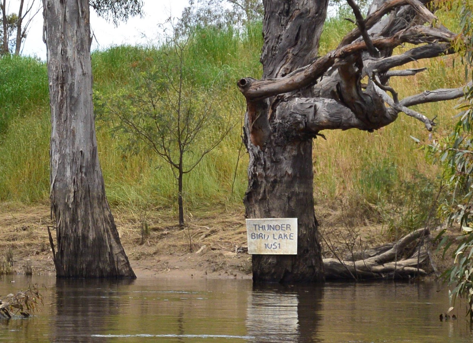
Thunderbird lake was built by a farmer for the purpose of racing hydrofoil boats. It was made by building a rectangular levee bank one kilometre long and several hundred metres wide and then pumping it full of water from the river. Races no longer take place and I am unsure what became of the lake, but the sign still remains.
Ruined farmhouse. Typically the first dwelling was single room. Initially a chimney made of flattened kerosine tins would be made. Later other rooms would be added and the chimney replaced with brick. Up until that time, the houses were made purely with materials from the surrounding bush and repurposed supplies. They are a testament to the resourcefulness and resilience of the early settlers.
Whilst the day began peacefully, the wind became progressively stronger, until I found myself punching through 40 to 50 cm high waves and against a wind which gusted regularly to 50 km/hr. It became difficult to take the photographs I depended upon for my research of bank condition. I had to give up on using my good camera and resorted to hurried single handed shots using my pocket sized Nikon AW130.
Amongst the wind and the waves there were still moments of sunshine and peace. I guess that is one of the benefits of having a river that meanders all over the place - at least some of the time you are out of the wind. These were moments to savour.
...and back into the wind... the nose of my boat would disappear up to my water bottles underwater at times. I was so glad for the work of the designers and manufacturers in building such a solid and reliable boat.


No comments:
Post a Comment