Day 42: 520 km Booky Cliffs 26th Nov 2016
Pike River Anabranch - Lake Alexandrina - Weir pools - Weekend visitors - Social experiments - Wilabalangaloo
I left Renmark around 9 am. A timely departure, seeing as my caravan park neighbours had just pushed off from the bank without their starter keys, and I was able to run these over to them. They told me that they had come from Goolwa, and that by the end of the millennium drought, there was so little water in the Murray Channel that a temporary wall was built from soil to make it navigable and to keep the salt from Flooding into the river. It was a contentious topic, with both long and short term residents split on what would be best. Many wanted the sea to be allowed into the lake as it naturally used to. Others thought this would kill off already weakened species. When the drought broke in 2012, it was removed.
Around the corner is the Renmark-Paringa suspension bridge. The road hangs from the framework above it. The lifting span is opened twice daily at set times. If craft want to go through at other times, they need to give two hours notice. A houseboat was approaching the bridge at full speed and continued to do so until approached by a tinny, who must have warned the occupants that they would not fit, because their turn was even faster. I thought I was going to see the span lift, as it was almost lifting time, however, no such luck. What did go under the bridge was a large clump of cumbungi, roots, leaves and all. I had heard that there were rafts of water plants floating, but this was the first one I had actually seen.
All the way along today’s stretch were campsites set aside for canoes and facilities for campers in general. It is certainly something that South Australia does better than both Victoria and NSW. Some of these were underwater, but the toilet blocks (thankfully) were always set up high. My camp tonight is one of those sites set aside for fishermen and canoe tourers. Set amongst bottlebrush and black box there are enough sites to cater for around 100 people. From my camp I was able to watch the last rays of the setting sun light the cliffs in front of me. There is no-one else here - perhaps the roads are cut off - just me and a family of red kangaroos. The camp is on a peninsula, with water and cliffs on three sides. Frogs are calling from amongst the reeds and the cicadas contribute to a low buzz in the air. At this end of the Murray one weir pool merges into the next, creating a flooded landscape. Old river channels carry water once again and billabongs are permanently filled. For canoeists it means that they can criss cross through the bush in a web of canals, getting up close to bird life and other wildlife. With the high water, some of those canals have got quite a bit of current flowing through them, which might be why I haven't seen too many people out and about.
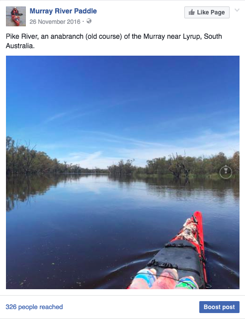
Some of the canals are as wide as the river itself. Pike River (which runs along the base of the high ground within which the River Murray meanders), is really an anabranch. There are signs at both ends pointing to the real river. On the higher banks, campers in caravans and old buses were a common sight. It is the weekend and Murray is no longer so far from Adelaide. A dad in one boat had 6 kids with him, having the time of their lives.
I pulled over to Lyrup for lunch and a stretch and read a bit about the town history from an information board. Lyrup was one of those communities which was founded in the depression of the 1890's when there was very little work in the cities. Many were communes, social experiments. Most did not survive the test of time, but Lyrup is one of the exceptions. They recognised earlier than other communities that a single manager was more effective at making decisions than a committee, they had more clay in their soil, which was better for farming, and they allowed outside work and money to be used instead of coupons. The information board not only lists the names of the original settlers, but also everyone who left and why. Some left because they were dissatisfied, some married and some were expelled. The names of those who stayed have become street names; there is Bollenhagen Place, Tschirpig Lane and Olson Road. Today the irrigation is still managed cooperatively and the town is proud of its history. Lyrup is an example of how irrigation existed along much of the Murray long before its system of locks and weirs were built. It is proposed in some quarters that the drought of 1912 alone was not enough to run the river dry. Pumps along the river took what was left. These events were important drivers towards national agreements, and eventually federation.
A little further down the river is a station with just as impressive a name. ‘Wilabalangaloo’. It is registered with the National Trust. You can visit the property and walk around several kilometres of tracks along the cliff top and through the gullies that divide them. Seeking an opportunity to observe the river from a high vantage point, I found a place with enough of a sandy base for me to pull in and followed a track to the top of the cliffs. To get a little more height, someone had placed a wrought iron spiral staircase at the highest point: a stairway to heaven. Although I would really rather have stayed on the ground I edged my way up the stairs, testing each step to be sure it was solid. I did not want to test the rails too much,as they might not have passed that test and I was glad for what was still there. Seeing the Lower Murray from above highlights how different it is from the Middle and Upper Murray. The river is much wider, the bends are longer, (most are two to six kilometres long) and when the wind blows along those straight sections, or big bends, there is nothing to stop it.
It was nice to see people enjoying the river. The last 1700 km have been pretty quiet.


No comments:
Post a Comment