|
| Bringenbrong - Towong Map. |
 |
| Towong - Tooma River Map. |
 |
| Tooma River - Tintaldra Map. |
Why Bringenbrong Bridge?
Most people who paddle the length of the Murray begin at Bringenbrong Bridge. From here, according to some entries on
Seakayakforum, you can use seakayaks, a popular choice with distance paddlers. The river had been low, which is no surprise at this time of the year, before the winter rains, but with rain falling the week before and more predicted I was hoping for a rise. You can learn a lot about the way the river responds to rainfall events by watching the monthly and yearly graphs at the Murray Darling Basin Authority's Live River Data -
Murray River upstream of Yarrawonga Weir website. The site shows the level of dams and the amount of flow at measuring stations. When you click on one of these, you are taken to a site which will give you more detail.
I was surprised to see that the river height at Bringenbrong Bridge was only 80cm. It has been raining all day. Watching the river gauge for the last week, I noted that the river rose by 80cm following the rain in the hills on the weekend, however that seems to have passed and the new rise seems not to have arrived yet.
 |
| A glimpse at the Hume (at 37% capacity) on the way to Bringebrong. |
 |
| Ruth (the better looking one - without beard). |
 |
| Low river: 80 cm on the gauge at Bringenbrong Bridge. |
 |
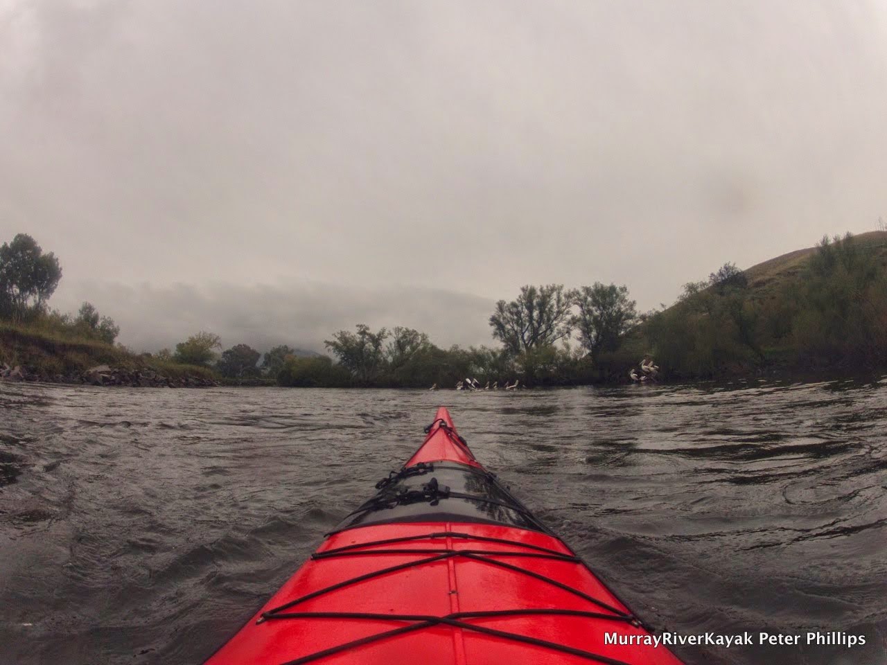
| Kitted up for a rainy day. 40 ml predicted. |
Getting the hang of white water again.
The river flows quickly, but not as fast as I thought... up to 7km where the current is channeled, but mostly between 3 and 5 km per hour. The willows are dangerous, with strong currents washing straight into them on the outside of bends. Paddling away from them at the last moment is a risky thing to do, as you have to use all of your power to get away in time. The best thing to do is to take a line just inside of centre, even if it means, as it often does, shallower water. You have to make sure that you have your line for exiting the bend before you enter it. This is especially important if you are in an expedition sea kayak as I am, as they tend to want to go straight. It would be very hard to not capsize if you end up in the willows. If you do capsize, stay upstream of your boat and if possible use it to swim yourself to safety. If you can't get your boat out, leave it. You can get another boat, and someone can help you retrieve it.


Gravel Races:
I came across a small creek at the 6 km point, it was followed by a wide gravel race. You can hear it as you approach. For a flat water paddler, that can make you as nervous as the high pitched whine of a southern 80 boat approaching from behind. I was soon to get used to these, however some are downright dangerous. Perhaps when there is more water it is not as bad. At this level the paddle-able channel is often quite narrow and I have to share it with willows and fallen trees. Gravel races occur almost every kilometre.
Pelicans
Something that I did not expect to see on the Upper Murray were flocks of pelicans: these hesitantly flew on as I approached, the pattern repeating itself all afternoon. I reckon they are ready for me the move out of their territory. Brown moorhens and the larger purple swamp hens move through the tangle of willow roots and branches.
 |
Farm fences, even electrified fences reach well not the river,
to control stock despite regular metre variations in river height. |
Towong
The Upper Murray is farming country, most of the banks are cleared, with cattle free to access the water's edge. There has been extensive work to stop the banks from eroding by adding large bluestone rocks.
 |
| Stuck on a gravel race, just before Towong Bridge. |
 |
| Towong Bridge. |
The river is quiet, although I have seen river camps, the only place I saw someone was at Towong Bridge, where I chose the wrong path and had to use my hands to push about 15 metres over a shallow gravel race. Instead of waving, or shouting encouragement, a woman photographed me in my moment of glory and went back inside, to show her companions what the water washed up. I guess that is where most other people are on a day like this too. Sensible, warm and relaxed - enjoying the sound of the rain on their roof.
 |
| Towong valley, before the river enters the ranges. |
Towong is famous for its 19th century
wooden grandstand at its race track. The grandstand was used in the filming of Phar Lap. Gangster, Squizzy Taylor stole a substantial sum of money there in 1928. Just out of Towong is
Farran's lookout, one of the best places to see the Snowy Mountains in Australia.
 |
The historic Towong Race Track, where Pharlap was filmed.
Towong is promoted as the 'Flemington of the bush'. |
|
 |
View from Farran's Lookout,
perhaps the most spectacular view of the Snowy Mountains in Australia. |
 |
| Upper Murray Valley downstream of Towong. Murray River Road. |
 |
| Upper Murray Valley downstream of Towong. River Road. |
 |
| Upper Murray Valley downstream of Towong. River Road. |
 |
| Upper Murray Valley downstream of Towong. |
Quiet
On the water, the near constant drizzle, created a misty winter's atmosphere. These are the peaceful moments, the water is dark and still. The willows and poplars on either side, have a hint of golden autumn colour and in the background the hills of the great dividing range are forming a picture perfect backdrop. A few grey herons and black cormorants are flying to another fishing spot, the cicadas are humming and I can hear crimson rosellas. In between these calls and movements, everything is silent.


Corryong Creek
Corryong Creek Junction has a modest entrance into the upper Murray. It is hidden by willow trees and can be easily missed except that it is on a sharp bend from the snags and one has to paddle slowly to negotiate these.
On the gravel island I leave to the left of me, just downstream from Corryong Creek junction, patrol two spur winged plovers.
After a 5 hour drive to get to Bringenbrong Bridge and an early afternoon start I am struggling to put in the distance I hoped to achieve today. To get to the Hume in the four days I have allowed, I need to do an average of 50 km a day. With the late start that won't be possible today, but it is more of a struggle than I expected. There are a lot of gravel races around. I'm managing these, but it's really tricky. In addition, the drag caused by the shallows slows you down. I have waves following me like a paddlesteamer on many corners. In-between the gravel races there are pools of still water. The current is actually faster in Albury - perhaps because of the steady flow.
Stately
yellow gums now tower either side of the river. I can see the road on the Victorian side. The rain has stopped and the water is dark.
Just negotiated a real heart stopper. The river slid left down a gravel race, with all of the current running through snags, and, just at the bottom through a fallen tree. I managed to thread in the eye of the needle - then the calm again. Knowing where this one is in future, I would advise pulling out and walking around. it would be no drama to do this on the large gravel bank.
 |
About 1 km downstream of the Corryong Creek junction was a difficult snag on the outside of a broad gravel race.
Pull up beforehand if paddling in low water. At high water, you should have more choices. Note how the border (grey line) does not change with the river. This causes all sorts of bureaucratic problems for farmers. |
|
| Location of strainer. |
 |
| Photo of strainer just after Corryong Creek Junction. |
 |
| Detail of strainer: safe passage = walk across pebbles. |

About 25 km from Bringenbrong Bridge I came across the first long straight. It is roughly a kilometre long and makes a welcome relief from winding curves gravel races and snags.
The water is clear I can see at least a metre through it. It is nice to think that our Murray starts out this way. You wouldn't want to drink it though, the cattle pollute the water with their faeces, the results are visible as foam around snags in the areas of faster current.
Tooma River
The
Tooma River junction is more picturesque than that of the
Corryong creek. It is a true small Australian river, emerging from amongst the river redgums - the first river red gums I have seen on the Upper Murray (since beginning at Bringenbrong Bridge. It has pushed a sand spit out into the Murray. The
pelicans, which have been flying away from me all afternoon, grunt in disapproval at my arrival and lethargically fly on again. I didn't say they had to move.
Again, all is quiet and I am lulled into what is probably a false sense of security. Around the bend there maybe another gravel race, another snag.
Camp
It is now getting late in the day for this time of the year. The light has a hint of evening to it. The smaller birds are starting to come down to the river now. I can see
grey fantails and
willie wagtails diving on the water's surface and I can hear wrens. The river is peaceful. It has a misty winters day atmosphere and is really quite beautiful.
 |
| Moored and secured nice and high in case the river comes up overnight. |
 |
River levels on the Upper Murray vary by up to metre on an almost weekly basis,
reflecting releases from Khancoban reservoir. Live River Data. |
 |
| My campsite is about 3 km downstream of the Tooma River junction. |
I paddled about 30km this afternoon and have a camp safe from a likely to rise river about 3 km downstream of the Tooma River junction. As with most sites at this end of the river, I am sharing mine with it actual inhabitants, the cows. I hope they don't mind.