The locals say the water is much better than it used to be, Jill and Geoff, the artist and farmer, who live in the beautiful Original homestead of Talmalmo Station and run Talmalmo Cottage, where we are staying, say that there are less carp than there used to be, so they must be doing something right. "In 1994, when we moved here, I was caught 90 cm long carp, really big ones, regularly. You don't see them anymore." I remember those carp from my childhood. The carp took over the Murray in the wet years between 1974 and 1976, when we had some of the biggest floods on record and a constantly high river. When the river went down to its normal level again, the banks were littered with dead carp of around a metre in length. We reasoned that, unable to forage on the floodplains, there was not enough food for them to eat and they starved. I can still remember their rotting corpses. There were too many to clean up. The riverbanks stunk. We didn't go near them again for months. Why the large carp persisted for another 20 years in the Upper Murray is a riddle to me: perhaps the constantly changing water levels in the Hume dam provide them with a niche environment which they are able to exploit better than any other fish. Trout Cod have been sighted again and the river is regularly stocked with juveniles of trout cod, murray cod and rainbow trout. These are all predators which would enjoy young carp as a meal. The pelicans, standing where the river shallows, like to catch the carp as they swim upstream, though some are too big to tangle with. Leaving snags in the river causes swirls which create holes in the river bed, including deep holes in which the predators like to hide. So although carp may travel up the Upper Murray from the Hume, it is a dangerous place to breed.


The stone re-enforcement of the river banks, so common between Bringenbrong Bridge and Jingellic have been put in place and paid for by the Snowy Mountains Hydroelectric scheme. Water is released from Khancoban reservoir when it reaches capacity, or is needed further down the Murray. Khancoban was built with the purpose of assisting in the management of water flow, however it's limited capacity makes this difficult. Local farmers tell that during peak load times, like when everyone turns on their air conditioners in summer, releases happen which can raise the river level by a metre overnight. It can also have to do with the days of the week - presumably reflecting power usage patterns - so that at some times of the year the water level will rise by one metre overnight on a Monday (for example). Water will also be released when reserves in the mountains have reached capacity, even if this contributes to flooding downstream. These regular large changes in river level make it hard for riverbank vegetation (other than willows?) to settle, leading to massive erosion problems . A farmer I spoke to said that every time the river rose he lost three to four metres of land. The Snowy Mountains Hydroelectric Authority is responsible for the maintenance of the river between Bringenbrong Bridge and Jingellic, which is why the bank stabilisation is so common there. For canoeists, it means choosing camps which are more than a metre above the river's current height and making sure that you have tied your boat up well.

According to a local farmer we spoke to, the section of river between Jingellic and the Hume is controlled by the Victorian North East Catchment Management Authority, the same that controls the Kiewa, Mitta Mitta, Ovens and King rivers. He said that the NSW parliament does not seem interested in their plight and that several local members have been elected with that mandate, but been unable to change a thing. Power for NSW inhabitants and services such as education, also seems to predominantly come from Victoria. I read an account in a local paper (The Border Mail, Saturday December 13th, 2008) from an elderly man, who lived on the NSW side at Talmalmo Station. When he and his brother were considered old enough to go to school, their father made them row him up and down the river for hours on end. They then rowed the boat across the river to where they kept their bikes and continued the ride to school. This they had to do rain, hail, or shine, whether the river was low or in flood. They were only four and five years old when they began to do this by themselves. This seems to be the plight of many NSW border towns along the Murray, they are so far from Sydney that they don't seem to be worth the investment. In Echuca, one of the main incentives to build that town's second bridge (the original was built in the 1860's - before the Titanic and Eiffel Tower), is that the 7,000 people in Moama would have no access to public hospital and secondary education services should it become impassable.
Talmalmo's School Bus Driver / Racing Car Champion.
The winding river road on the NSW bank is home territory to rally car champion, George Fury. Fury, also known as 'farmer George' was multiple times Australian Rally Car Championship, twice runner up in Australian touring car championships and the holder of pole position in the 1984 Bathurst 1000. Racing biography. When not racing cars, George was a school bus driver. Source. I'm sure the ride to school was an interesting one.
|


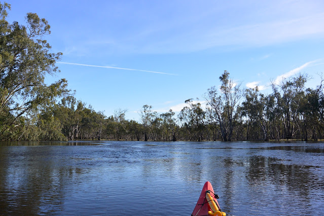
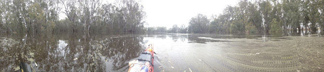
Imagining those two boys in their rowing boat, prompted me to consider, once again, what the ideal boat for this section of the river might be. Whilst sea kayaks are great for keeping gear dry, are a fast expedition boat and do not catch the wind as much as a Canadian canoe, the later may be better in these conditions. Sea kayaks are difficult to turn and even more difficult to get out of. Canadians are stable, turn quickly and could not be easier to jump out of to push yourself off a gravel race, or to investigate a potentially tricky situation. This means that it is also easier to pull up and assess rapids, snags, or tight corners (which also means that you are more likely to do this). If you capsize you are out in a hurry, which can be very important where there are snags which could catch your life jacket and hold you under. Importantly, when you capsize out of a Canadian canoe, your life jacket and head do not go underwater, they do in a sea or whitewater kayak. So there is less risk of you being caught on a snag underwater when you tip out of a Canadian canoe than when you are sealed into a sea kayak. If you would like a taste of the Upper Murray, the Upper Murray Resort can provide boats gear and advice on where and how you can do this safely. If you are doing the whole river, consider ditching the sea kayak for this section.

If you have the opportunity to get out of your boat and explore the Upper Murray valley by road, then travel to one of the many lookouts and take in the magnificent views of Mt Kosciusko and its companions. They form an impressive bulwark at the head of the Murray Valley: sentinel guardians of a river that provides nutrients and life to so many in its three month, two and a half thousand kilometre journey to the sea. It feels like a pilgrimage and I suppose it is one of sorts to see these mountains. From the lookout near Tintaldra, they stretch further than the eye can see. Kosciusko is so high, it has formed its own clouds and was hidden by the rain within them. Almost all of the water that flows down the Murray comes from the high country, rainfall and runoff is much lower on the plains. This is unusual for a river. It heightens my appreciation of the water that I have been kayaking on in the Upper Murray these last few days. This is all there is, there isn't anymore. We now have the job of sharing that water with the seven or eight million other people who depend directly, or indirectly on its water, produce or life giving properties.
‘Look after the land and rivers, and the land and rivers will look after you’
Sitting on the balcony of our riverside cottage, watching the sunset, the stars rise and the river travel ever further towards the sea, I already have a plan to return, to accompany it on that journey once again. It is always a privilege.