Albury - Howlong. Tree branch camp.

We took off in the morning cool. Early morning is peaceful, the water is smooth and the sun, still low in the sky, casts a warm light which causes the yellows of the cliffs to shine golden and gives a freshness to the gum leaves that you would not imagine if you were only to observe them in the middle of the day.

Detail of a corner where benched had been hewn from old red gums for campers to use just before the 2170 marker. I have never seen such massive forest furniture.  The morning light was also quite inviting, providing near perfect reflections.


Today we paddled just over 50km, finding a beautiful grassy spot a few kilometres downstream from Howlong. There were less cattle than yesterday, but we did first hear and then see a herd of cows moving through the forest. They were obviously using sound as a way to keep together. Lead cattle bellowed to the slower ones, encouraging these to catch up and the later letting the first ones know that they were coming. Occasionally it is hard to hear things on the water, there were times when each of us thought the other had said something, only to be told in a most unimpressed way that that was a cow bellowing!

The bush was beautiful today, it reminded me of paddling through the Narrows (upstream of the Barmah Lakes), with its low banks. Now that this section of river is high, it is as though you can see right through the bush. The trees look lush and healthy, they light up as the sun shines through their leaves. It is quiet, there are very few people on the river, only the occasional fisherman. As we neared Howlong there were a few speed boats, but not the highly styled Malibu's of Echuca and downriver. These are old fashioned, with V8 engines, or smoky outboards, and, because there are so few, they are super cool. The river banks are healthy, there is little sign of erosion, other than that caused by the high river. Everywhere reeds grow, the banks are secured by goynes and stones. Willows still grow, but do not dominate. One feels they have a purpose.  Ruth remarked that it was so nice to see the animals owning the shore.


The river banks, whilst usually low for the first 100km downstream from the Hume Dam are beginning to show a bit of height. These clay banks although, at times similar in colour to those at the lower end of the Murray River, are much softer and do not seem to stop the river from meandering its way through the landscape. Occasionally, lines of pebbles can be seen crisis crossing through the strata, evidence that the river had been there before. The town of Howlong was on top of one of these cliffs.


Howlong

We pulled in at the public boat ramp at Howlong. It was surrounded by at reserve which people treated as impromptu swimming areas. People just rocked up with deck chairs and eskies, and stayed the afternoon. There are big shady trees. A couple with their two big Great Dane like dogs, sat in the cool shade of these, every now and then entering the water with their dogs to cool off. The place to be in town for young people was the Howlong Central Cafe, where we ordered a refreshing smoothie and milkshake. After that, they too moved to the park by the river; some swam, others sat on picnic tables in the shade of trees with their eskies and played music. The town was similarly laid back. Homes were neat and tidy, rather than audacious.

Howlong Hair.
Howlong has a population of around 2,500, and according to its community website, 'The Grape Vine', the population is growing -due to the affordability of housing compared to the surrounding towns of Rutherglen, Corowa and Albury, its proximity to wineries and the "niceties of country living." Some of those niceties are of the wriggly kind; the biggest advertisement in the Grape Vine in April 2014 was for the services of the local snake catcher; another was for tennis. I wonder if the two are connected?

Howlong's name derives from 'oolong', meaning 'a haunt of brolgas'... although other references say that it derives from a word indicating 'the beginning of the plains'. Since Brolgas are plains birds, this is not as contradictory as it might first appear.


Howlong is located at the junction of the Murray River and Black Swan Anabrach. It is high above the river, the low ground between the two river sections is regularly flooded.

Major Thomas Mitchell in his exploration of the area, camped at the site of the future township on the 17th October 1836 and then crossed the river slightly downstream on the following day. Several years later, in 1838, John Conway Bourke delivering the first overland mail from Sydney to Melbourne chose this place to cross the Murray also. The town was established in 1854. 


1861 Post Office (now a B&B): ref: By Mattinbgn - Own work, CC BY-SA 3.0, https://commons.wikimedia.org/w/index.php?curid=6414671
One of the surprising finds in Howlong are the 'Black Dragon Gardens'. Based on the scholar gardens of Suzhou and inspired by artists, writers and poets from that time and place, the owners seek to enjoy a symbolic natural world in their own private space. The gardens are open to the public on weekends. More info at http://www.suembroidery.com.au/ 

 http://www.visitnsw.com/destinations/country-nsw/the-murray/howlong/attractions/black-dragon-gardens-wulong-yuanhttp://www.visitnsw.com/destinations/country-nsw/the-murray/howlong/attractions/black-dragon-gardens-wulong-yuan


Howlong features in Australian band Spiderbait's album, Grand Slam.


Yesterday we met a man who used to train in K1's between Albury and Howlong. They used to use the backwaters to create a loop. It is no wonder that the Mitta Mitta canoe club had such strong paddlers (they regularly had members of their club who represented Australia). He told me of a short cut which they sometimes took on the way to Howlong, that would cut about an hour off the journey. Later, I believe we found it. There is an anabranch which runs parallel to the river for 30 or 40 km. little inlets and creeks poured off the main river all along today's journey, eagerly seeking the quicker way to the sea. Paddling down the river, you had to be careful not to be sucked into one. As the paddler told us that they were full of snags and that they were sometimes so narrow that once you were in you could not turn around. It wasn't worth the risk.

The river continues to meander through the landscape, changing its bed, it seems, on a whim. Because of this, and the hills limiting its movement on either side, the landscape is full of billabongs. This is the favorite environment for the river red gums. They love the river, moist soil and can handle being underwater longer than most native trees. In these photos I admired, and tried to guess the age of the old gum with the wide base. How old do you think it might be?
Cicada shells, depending on the species in Australia, they can spend up to 5 years underground, before they emerge from the ground and take on their adult winged form. Adults live between two weeks and 3 months, seeking out mates. The males are the loud ones: females click in response.

The riverine landscape is constantly changing, leaving billabongs, marshes and undulating landscape as the river moves across its floodplain and back over long periods of time.


Stopping for a break by one of the many inlet 'creeks' which serve as shortcuts for the river when water levels are high.


A few kilometres after Howlong we found our camp site, a beautifully green, shady and cared for area. Perhaps we had lucked on a private piece of land where campers were welcome, or perhaps this is one of the new Murray River National Parks. Either way we were grateful. We arrived with enough time to have two swims to cool off, which we hope will make all the difference with sleeping tonight.

Beautiful grassy camp, just downstream from Howlong. Tied the pool noodles to an overhanging tree branch and cooled down after our paddle in the afternoon.
Plenty of fresh veges.
Looking forward to dinner. Carbonara pasta base, garlic, onions, capsicum, tomatoes, squeeze of lime and tuna.


Hume Dam - Albury - Island Camp.


Bridge just below the Hume Dam.

River of islands.

The river is so different up here, fast flowing and low banks. Here we navigated two small islands in the middle of the river. From the air the river twists and turns. Billabongs are everywhere. It is a haven for wildlife. We saw flocks of black and brown kites, wedge tailed eagles, pelicans, ibis, rainbow bee eaters, grey tree creepers and at one stage flocks of low flying swallows which seemed to cover the river.

Its banks are lush and green. It feels as if it would be easy to pull up and camp anywhere. There is little or no housing development to be seen. This seemingly tame, rural environment is a stark contrast to the dry bush of further downstream. European trees are common, in particular poplars and willows. One island we passed was covered in elm trees and ivy, in the moist soil the forest looked like a patch of Europe.
Poplars and willows are common along the Upper Murray.

The river is swirly and fast. Care needs to be taken to steer away from willows well before the bends as the current often sweeps directly into and under their overhanging branches. It is also a good idea to have minimum gear on deck on these first few days: the likelihood of losing it is high.


Taking a break as the heat of the day settles in.


In this satellite photo you can see how the river twists and turns, abandoning old courses as billabongs and forging new ones. It is hemmed in by hills to the North and South. The Hume freeway in the South and Riverina Highway in the North run along the edges of those hills.


The Murray is a natural waterway managed in a human environment. Whilst the satellite picture that you have just seen shows how the river has changed and continues to change, the amount of water allowed to run down it and when that water is allowed to run is controlled in a bid to meet the needs of people all along the river as well as to keep the river and its wetlands healthy. At present, about 20,000 ML a day are being released from Hume dam, so the river is near the tops of the banks and most of the gravel races are underwater. This is because the summer months is when farmers irrigate. In the winter months, flow can be as low as 600 ML a day. This is in stark contrast to the natural patterns of flood and low river along the catchment. It has contributed to the demise of health of river red gum forests which depend on short, sharp winter floods to reproduce and rejuvenate the soil. In the last drought many wetlands and lakes were filled or allowed to dry out depending on the effectiveness of lobbying from groups and states concerned about them. The communities of Lake Boga and Pyramid Hill almost disappeared when the water they depended on did. The new Murray Darling Basin Plan contains strategies to ensure that these areas are not forgotten. It is motivated by the stories of real people and real places behind the controversy. 

The basin plan is an attempt to make the way we use water in the Murray Darling Basin sustainable. The Living Murray Initiative in addition identifies six icon sites as being of particular significance and focus. One of these is the river bed itself, others are areas which the river supports, like the Barmah-Millewa Redgum Forests. Wetlands and lakes can now be filled using systems of channels which run off weirs like Yarrawonga, Torrumbarry and reserves like Lake Victoria. They keep the river alive and help us to grow enough food for our increasingly urban populations. Improved systems of dams, gates, channels and levees in the red gum forests mean that these can now be watered at the right time, whatever the level of the river (Barham Koondrook Perricoota Forest Works. Updates).

Whilst the management of the Murray River and its flow are a necessity for the populations that live along it, it is refreshing to find an unregulated river. The Kiewa river may flow through farmland for much of its course, but it is still wild. It enters the river quietly most of the time, but can be a raging torrent. It is easy to paddle past and not recognise its significance: one of the last free mountain catchments in the Murray Darling Basin.

The Kiewa River Junction.
The junction of the Murray and Kiewa rivers. The Kiewa, Ovens (and its tributary, the King river) rivers remain undamed, the only mountain catchments to remain in their natural state. This means that they can flood quickly following heavy rain. Care needs to be taken when camping on their shores. The Kiewa has its headwaters around Mt Bogong, whereas the Ovens begins near Mt. Buffalo. Both are very pretty valleys, are heritage listed and are very popular amongst fishermen. There was not much coming down the Kiewa today, but there were times when it was in flood last year. Things would have looked different then.


Goulburn Murray Water: Kiewa river.
Goulburn Murray Water: Ovens river management plan.

Active steps are being taken to improve the catchment health of both basins. Fish are being used as indicators of the river quality, in particular the presence of cod and trout cod. The following oral history was is an exerpt from True tales of trout cod: River Histories of the Murray Darling Basin: Ch 11, Kiewa River Catchment. You can read more at Australianriverrestorationcentre.com.au.

OH 95


Bill Murphy of Kergunyah was interviewed in April 2008 at an age of 73 years.

I was born in ’35. I remember my uncle went down here and all the lobsters were in the back of the Ford. I saw the lobsters; they were coming out of the river after the fires. He was fishing down here and there was a 70 pound cod dead, down near Doug Austin’s. Cliff Cooper told me there was cod all the way up past Tawonga before the fires. Apparently there was a few about 90 pound caught around here. There was an old bridge just below my boundary; there was a 90 pounder there. There used to be a few Catfish here, my father used to catch them in ‘the old river’, where it cuts through the paddock. He also talked about getting some other type of fish there. The Blackfish were in the little creeks, some people used to get a feed of them. There used to be some in the Bells Creek and the Running Creek. There were no yellowbelly here, not as I remember, and grunter, no.


When I left school the river was full of trout, you could catch them on worms up to 11 pound, then they started to disappear. The redfin then used to be thick, then they disappeared with a fish disease. I saw them dying in the river about 25, 30 years ago. I haven’t caught a carp for two to three years. I once saw six about 10 pound each eating the leaves off the willows. Now the river is full of small cod, though they get a bit of a hiding. Felix Carmody was a character and a well-known poacher.. He used to catch black snakes and once he tipped one out in the pub, that soon cleared the bar!
Ref: True Tales of the Trout Cod: River Histories of the Murray-Darling Basin: Ch 11 Kiewa River Catchment.


The Red Eye Cicada can be very common in one year, with thousands of individuals in one tree and completely absent the next (ref). Different cicadas emerge at different times of the year.  They make good, although short-lived children's pets (ref).
This little fella was too big for the camera. Almost broke the lense. The cicadas are enormous up here... And loud. We had to abandon one potential campsite because we thought we would not be able to get to sleep with the noise. The cicadas answered each other on different sides of the river; one side would listen whilst the other would perform, before performing itself. They make their loud noise by rubbing thick chitinous plates on their abdomen together. These vibrate as they pass over each other causing the noise - much like finger nails on a black board. Later, we were told that cicadas are only noisey in the daytime, that they are quiet at night. Potentially we could have kept that first campsite, but we would have needed ear protection if they hadn't quietened down... and we would never have found the lovely island campsite that we eventually found for the night.

If you have really had enough, I found out that cicadas may be eaten, they were on the menu in China, Burma, Latin America, the Congo and in a single batch of ice-cream at Sparky's in Missouri, Columbia. They were warned by health authorities not to make a second batch and complied.

Cicadas spend most of their life feeding on the roots of trees, they emerge en masse to overwhelm predators.


Island campsite.

Cooling down after a long day in the sun.

We eventually found a nice spot a little over 50km down from the Hume. It is a small island, which is nice. I like camping on Islands. The current is fast here. Not even sand can settle. There are little trails of sand behind the tree trunks from when it has been covered by flood waters. All around the island are pebbles and gravel races.

Other paddlers have since told me that they too had camped on this island, however no trace of their passing could be seen. This is the way it should be. We should strive to leave so little impact that the people who follow experience the environment in as good, or better condition than we found it in.

More and more people want to enjoy our rivers, which is great, however the very people who love the environment can destroy it. Outdoor education teaches mantras such as leave only the lightest of footprints, take only photographs. As canoeists, our touch should be particularly light. Make it a challenge.

This website from Backcounttry Atittude outlines steps you can take to minimise your impact. It starts with good planning. Leave No Trace Outdoor Ethics & Skills For Outdoor Users. Many families who camp along the Murray pick up rubbish left by less careful occupants. It is a good example to follow.

The Murray River Guardian is a free magazine put out as a cooperative project between Parks Victoria and NSW National Parks. It is a guide to camping along the Murray in both of those states and contains practical tips and valuable information. It is worth getting your hands on one before you paddle.


Parks Victoria's website on the River Murray Reserve provides up to date information on changes in conditions along the river. Check it out.


Evening light from our river island.


Evening light on our island.

Dinner.


Preparation for our paddle from the Hume Dam to Echuca.


Cleaning out the boats. They should at least start free of Murray Mud. :)

This will be the first time for me on the Upper Murray and the first time paddling with my beautiful wife and soul-mate, Ruth.  

We are looking forward to exploring this beautiful stretch of water and sharing each other's adventure so much! I swore after my trip from Echuca to the sea, that my next trip would be with my wife. Journeys like these are as affirming and life changing as they are beautiful. For me, it is important to share them and with the most significant person in my life, doubly so. The trip was a chance for Ruth to witness how the river is important to me and for me to further understand why. In addition I had the pleasure of the company of my best friend and, as it turns out, after 23 years of marriage, being thrilled by her strength, bravery, good nature and humour. I was also humbled by her tolerance of me. I have quite a few rough edges.

But I am jumping to the end before I have even begun. Now that we had decided to go, how does one go about getting a show like this on the road?

The first step in preparing for this trip was working out what we were up for. This means tapping into the experience of others, both in the form of river guides and other paddler's experiences.


There is a very good river guide called 'River of Islands: Charts of the River Murray - Yarrawonga Weir to Hume Dam' by Kath and Leon Bentley (1985) which is worth acquiring. It is mentioned in Barry and Maureen Wright's 'Murray River Charts' and available on the CD version of their charts by agreement with the authors.


http://www.rivermurraycharts.com.au/

Murray River Access Guides provide an alternative to the above publications and at around $8 a booklet in 2014, they are a good deal. They include roads and river kilometres, but do not show snags, or include insights and history about stretches of the river as the other publications do. Whilst it is possible to see where you are using google maps, for the convenience and safety of knowing where you are at all times, it is worth having one of these maps. Phone reception is poor along many stretches and technology requires batteries and charging strategies which can fail. It is better to have a hard copy.

https://svmaps.com.au/ 


We were lucky to have advice from others based on their experiences in the Upper Murray. This helped us feel much more confident on approaching this stretch of river. Even though conditions change dramatically with river level and time of the year, reading the accounts of others helps to understand the nature of the river and its potential dangers.

River levels change rapidly depending on the time of year and the needs of users and the environment downstream. In preparation for the irrigation season, 50 times more water is released than during the winter. Check water levels before you go. If the river has dropped recently, banks can be steep, high and muddy. Some paddlers have even experienced quicksand. Beware, a wet beach may not be firm - test with your paddle first. If your paddle slips in, don't step out. Mud can make camping in caravan parks an attractive alternative to bush camping in these conditions. Boat ramps, especially larger ones, are reliable exit points. High water is easier to deal with. At times of high water it is easy to find camping spots. There are beautiful islands, grassy banks and plenty of safe room away from tall red gums. At high water Albury is difficult to pull up at. There is a boat ramp just downstream of the park in town, or, if you can manage it, roots to clamber up. Floods are rare as this section of river is usually able to be managed within its capacity and the effect of irrigation water rejections due to unexpected rainfall events is more of a problem from the Barmah Forest onwards.

If the river is low, there are many gravel races and pebble islands as far as Howlong. These will be shown in the river charts, but not the access guides. Alternatively you can see them using google maps before your trip.
Example of map from Murray River Charts


Shallow water near Albury: Google Earth

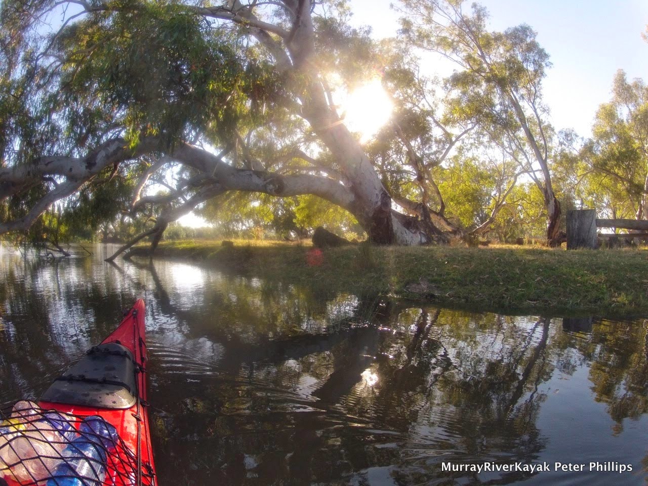
Generally follow the current, (this will be where the deepest water is), however, beware of being washed into willows and snags. The fast current means that you need to turn away from hazards well before you get to them, otherwise the current can take you sideways into them. The fast current also makes large and at times, powerful swells, which can appear suddenly and unexpectedly move your boat around. It is not the best place to learn how to paddle: this is better done downstream of Echuca where the river is slower. If you do fall out of your boat, keep your legs up and in front of you, so that they do not become trapped in snags (and you can use them to bounce off them should you be swept into them). Look after yourself. Your boat can be replaced. Do not allow yourself to be between your boat and a snag, you may become trapped. If you are a new paddler, only take on this section if you have good balance and are confident. It is a good idea to have an experienced paddler with you. People have descended the upper river alone with little paddling experience, but it is not a wise thing to do.

In sea kayaks turning can be difficult. To turn around, use the eddies on inside corners and snags. Nose into these and allow the current to do the work for you. It will bring the back of the boat around. Approaching the bank facing into the current is a much slower and gentler process where you will have more control. When pulling out from the bank, leave your stern against the bank, allow the current to catch the bow. Only start paddling once you are facing the direction that you want go. Given how narrow the river is at times, how fast the current is, and the number of snags it can be the only way to turn around at times. It is best practiced before you go to the Upper Murray. The same skills are very helpful in the narrows upstream of Picnic Point.


Turning into the shore using the current to bring around the stern.


Using the current to take bring around the bow when leaving a beach.


Navigation near and in Lake Mulwala can be difficult. To add to the complexity, the Ovens river joins the Murray river here. Without good charts it is easy to go off into side channels, or even end up in the Ovens. It may pay to have a topographic map, or use your smart phone for a GPS fix through here. Keep a sharp eye out for channel markers. Take time to explore the billabongs and side waters if you can. Locals and fishermen call the area 'the Everglades of the Murray'.

Since the weather is expected to be hot we have prepared meals which can be eaten hot, or cold, without creating too much rubbish. This includes a lot of fruit and vegetables. We chose hot weather things as these seem to last longer. Each day we inspected their quality and ate thise which needed eating first. We had very little wastage.

Fruit and veg for ten days for two people, with some top up possibilities along the way. This all went in the front compartments of one of our boats.

This initial pack list for my paddle from Echuca to the sea, which we used as a guide for what to take. Every trip is different, but it is good to develop a check list and work from there.


The next step is to actually get everything out, get a visual and check the condition and amount of gear..


Then check everything on your boats. Take tools and know how to fix them.

Facebook entries: Murray River Paddle