A journal of canoe expeditions along the rivers of Australia's Murray Darling Basin using photographs, stories and information to highlight the beauty, challenges and history of these rivers and the communities they flow through.
With only a short run into Robinvale today, I took time for a cuppa and a good chat with Jess, who had turned up for another day’s work at the farm. She brought in two avocados, one of which made a lovely lunch out on the water. It was a perfect day for paddling, no wind, clear skies and river landscape.
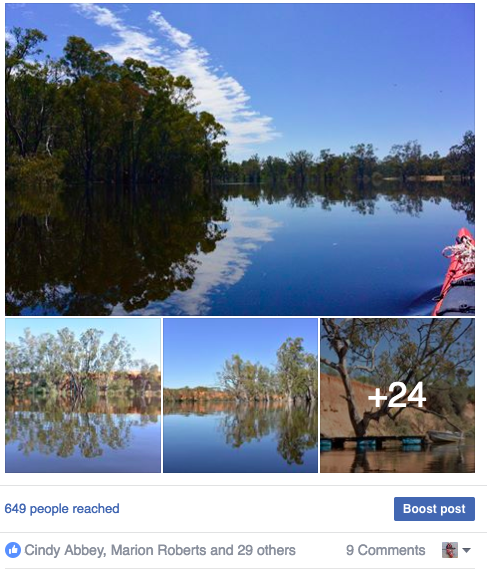
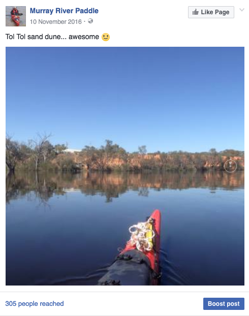
There were three notable points on the river today. The first two were sandhills, the biggest so far. The sandhill at Tol Tol would easily be 15m high and its little brother a few bends earlier was not much smaller. I agree with Andy and Albert Gorman, the down stream side of the first would have made an excellent camp. It had a gentle slope that ran into the river up from a black box woodland and was mostly covered in grass. Too many sticks are a bother when you have a tent.
The remarkable thing about these sandhills was that although they are generally very easily eroded, these had stood up to the high water and strong currents without any sign of bank collapse, or even damage. The difference between these and most other sandhills I have seen was that they had a belt of redgums and river myall had grown along their base, all but stopping the flow of water in front of them. Collapsing sandhills have been a problem along much of the last 1,000 km and particularly worrying for people who have their houses on them - great to keep above the flood waters - not great if they collapse. So the trick seems to be to vegetate the base.
Leaving 'Little River Cottage', a welcome dose of hospitality, kindness and company.
Perfect day for paddling; no wind, clear skies and impressive river landscape.
YouTube: Just after 1156 at the cutting downstream I can see a swallow capturing mosquitoes of the water surface, morning calls, dragonflies flitting across the surface of the water - they're always welcome - water is still and the sky blue…
Sandhill downstream of Tol Tol
Edges of sandhill make good camping spots.
YouTube: Note the stability of this sand hill, with red gums growing as a protective buffer to the currents of the outer bend. No doubt on sediments that have collapsed due to erosion, however this layer of vegetation both protects the sandhill and captures future erosion, allowing recolonisation by other red gums and you can see here, the Acacia stenophylla, and as the face becomes less steep, also by saltbush and grasses…
The third feature of note was Bumbang Island. This is a 12km piece of land which is now cut off from the rest of Victoria by the river, which is in the process of cutting a new course to its South. Saving kilometres is more efficient. Today the river was racing through there. There is a spot, just after a clay bar in the middle where there is a strong undertow. Logs have been seen to disappear there and only surface a hundred metres further downstream. I have been through this cutting at low water. I had no desire to take chances with the power it had in high water. Bumbang Island is an aboriginal reserve and wildlife sanctuary. Today, most of it was under water and there was very little current for the full 12 kilometres. If the water is shallow enough it could cause black water trouble for Robinvale, which is immediately downstream. About half way around Bumbang are the remains of an old post and rail stockyard. One corner of the stockyard is fixed by wire to the oldest black box I have seen in my journey so far. It was well over 2m in diameter. Given that black box grow much slower than river redgum, this would make it many centuries old indeed. Not many old trees remain, Andy Gorman of Meilman Station informs me, because when steam was still the primary source of energy in the bush people worried that they would run out of dried wood and Chinese labourers, seeking work after the gold rush were employed to ‘ring the trees’, leaving them standing until they were needed. Many are still standing. Black box is growing back, but since it takes such a long time to grow, it will be centuries until the landscape approaches its earlier form.
Floodplain forests of river red gum and black box. In the last image a spoonbill can be seen wandering along the top of the bank.
Wide smooth and dark. Flood waters nearing Robinvale were low in oxygen and high in organic matter.
.
YouTube: Small patch of saturated CPOM right of mid stream... Approaching Tol Tol and the sand dunes are definitely getting bigger.
The lower end of the second sand hill tapers off to provide good floodsafe campsites.
Groundcover vegetation amongst black box on top of the river bank.
Habitat trees on the bank edge. Approaching Bumbang Island.
A little further is a lagoon, hidden by the trees which have grown over the place where it used to join the river. The lagoon is the way to Euston Station. The original station, settled by Edmund Moray in 1846. It was Moray who embarked on a trip to Adelaide to propose that stem navigation on the Murray River had potential. The South Australian Government supported the initiative, setting a 2000 pound prize for the first steamer to reach Swan Hill. Two people answered that call, Francis Cadell and William Randell. Randell, with little ship building experience built the Lady Augusta near Mannum. It had a square boiler which was held together by chains because under pressure it began to swell. Cadell had his boat made in Sydney and delivered. Both were unaware of the other until arriving at Euston, Robinvale’s sister city, then the race was on. Cadell won by half a day, but both remained key figures in the development of the river trade which played a key role in the development of inland Australia.
To support that trade, 26 locks and weirs were planned along the Murray River. The idea being that boats would be able to travel along the river at any time of the year, that communities would not run out of water and that irrigation would be possible on a larger scale than was possible with steam pumps along the Murray River. Only 16 were ever built. Torrumbarry weir was supposed to be number 26, it is the furtherest up the Murray. After that comes Euston, which I will probably pass over tomorrow, given the height of the river. Nothing was built in between. Paddle steamers were overtaken by a steadily expanding rail network and the construction of the Hume Dam had begun in the 1930’s. They were seen as no longer necessary. The weirs remain a legacy of the past, but one which enabled the rich agricultural industry in this part of the state to develop. Their weir pools created permanent wetlands, which are important breeding sites for water birds and fish and the steady water levels are attractive to water sports and real estate development. From here on the river changes again. Particularly in low river, one journeys from weir pool to weir pool. Today, with a natural Spring high water event, that is not the case. I look forward to a different take on this section of the Murray River.
Wide river landscape approaching Robinvale.
Peaceful, slow flow around Bumbang Island - most of the current flowed through the cutting.
Company for the run into Robinvale: thanks Kia!
Historic sheep yards.
Dead river red gums in billabong flooded by water backed up by Euston Weir.
Robinvale's famous Oasis Pub... lost to fire. I had to find somewhere else for a pint and parmi
Yungera Station: pulling my fully laden boat to the river.
Yesterday I passed a major milestone. Just before Tala Rocks, the only known stone fish trap on the Murray that remains today, I passed the point where I had paddled 1000 km since beginning at the Hume Dam about four weeks ago. If you take away days set aside for organisation, rest and time with family, that's close to an average of 50 km a day, which is the target I set myself given the necessary delay to the beginning of the trip caused by major flooding in the Upper Murray.
YouTube: Approaching the 1200 km mark just after Yungera Station (morning bird call).
Overbank flow through blackbox and river reg gum woodland, just after Yungera Station. Saltbush and Exocarpus understory.
YouTube: Between 1194 and 1192 opposite the Yungera Island just passed a big area flooded Black Box where where the river and travels more through the forest then it does down its channel... leading to pretty much next to no current in the bends... picking up slightly now ...maybe doing one kilometre an hour ...that area of box Forest is really quite special with trees over 1 m in diameter and and many canoe trees amongst them ...in one spot I counted about five canoe trees in about 200 m.
In that time the river has changed from looking like a mountain stream, with the hills bordering its catchment clearly visible on either side, to a broad meandering river with 6 km long bends. Above Yarrawonga the Murray was confined to its ancient river bed, regularly flooding and changing course in its narrow valley. Blocked by an uplifting of the earth's crust between Echuca and Deniliquin, it was forced out, split into two rivers, which rejoined, flowing back into the ancient channel 400 km later. It has passed through two giant Redgum forests, the first built on sediment dropped when, blocked by the uplift, the Murray formed a huge lake, and the second, the remnants of a delta where it used to flow into the inland sea that the explorers sought but never found because they were 30 million years too late. Now I am paddling under that sea. No longer covered by waves, I am in the arid zone. Whilst the red gums remain, black box is becoming more common. The silver wattles have been replaced by River Myall and Saltbush and Lignum line the banks. The salt left in the soil beneath the surface by the sea continues to challenge both people and nature. How they cope with this will be part of the story of the next 1,000 km.
Since the Wakool Junction, the river channel has increased dramatically in width. The parts of the river which flowed Northward around the Cadell Tilt have rejoined and flow is notably stronger. Once again, the Murray is and its floodplain are contained within the channel of the much larger and more powerful stream that existed here in ancient times. The high banks are visible as red cliffs when the river reaches the edge of this corridor.
In the place that this photograph was taken the flow in the river channel has almost stopped, with most of the flow taking the shortest possible route through the forest. This means that there is only current in those sections of the river which run the same direction as the water is flowing. Current speed varies from zero to seven kilometres per hour. In this photograph water is flowing slowly out of the forest and into the river channel.
YouTube: Yungera State Forest beautiful old gums... I've just passed some High ground back here... The High ground tends to be on the outside of the bends it's not surprisingly really has the river is always forming new lower ground on the inside of the bends... meaning that the High ground, the oldest ground built-up through sediment deposition... floodplain sediments or aeolian Sandhill sediments and this is usually where you will find your Black Box ...not surprisingly ...so outside of the bends and usually at the start of the bends you'll find this fellow, Acacia stenophylla with its long thin dark green leaves... and the peak usually not the end and your find Black Box on the outside of the bends and Red Gum floodplain forest on the inside of the bends and immediately downstream on the benches.
Round Yungera Island, so much of the rivers water is flowing directly through the forest that there is next to no current at all. It makes for a pretty picture through. When the light is right, the forest floor sparkles as the ripples from the flow catch the sunlight. Slow flows through the forest create areas of blackwater. I'm yet to see fish kills resulting from it in this area, however it could be that these have been caught in the forest debris. Now, after 4 weeks, I seem to have old caught up with the flood pulse down the Murray. Floods travel like long waves down rivers. The pressure of the wave causes the water to rise even before the flow does. Both are slowed down by the forests. They absorb the flood pulses, protecting those areas downstream and release it slowly, a bit like a mountain spring. This is why high rivers downstream of forests last longer than those upstream. From here on the Murray sticks more to its channel and both the changes in height and flow should be more predictable.
Old Black Box with Saltbush and Lignum understory on the outside of a bend.
Organic matter stranded in an eddy amongst vegetation (Saltbush, Lignum and River Myall) at the bank top NSW, forming a thick mat on the surface for the first metre away from shore.
Right at the peak of the flood wave... Rising flood waters spreading through a Black Box woodland at Boundary Rocks, opposite Cod's Head Reef Campsite, Yungera Island.
At Boundary Rocks I pulled up for a short break. There, the most enormous whirlpools visibly sucked down the surface of the river by up to 10 cm and have a diameter of up to 5 m. Some of them appear suddenly. I took care to stay well away. They are caused by the way the current flows over the rocks below them. We tend to think in two dimensions when it comes to water, but movement occurs in three. The swirls caused by snags and rocks include currents that come to the surface, creating boils and others that go down. When these are extreme they cause whirlpools. Its part of what makes some parts of rivers quite dangerous. The Murray seems so tame, but it has its traps. It is, after all, a wild river. On the shore I can see the waters edge gradually creeping millimetre by millimetre further, or is it receding, when you're at the peak it's hard to tell.
Dragonfly resting on my camera.
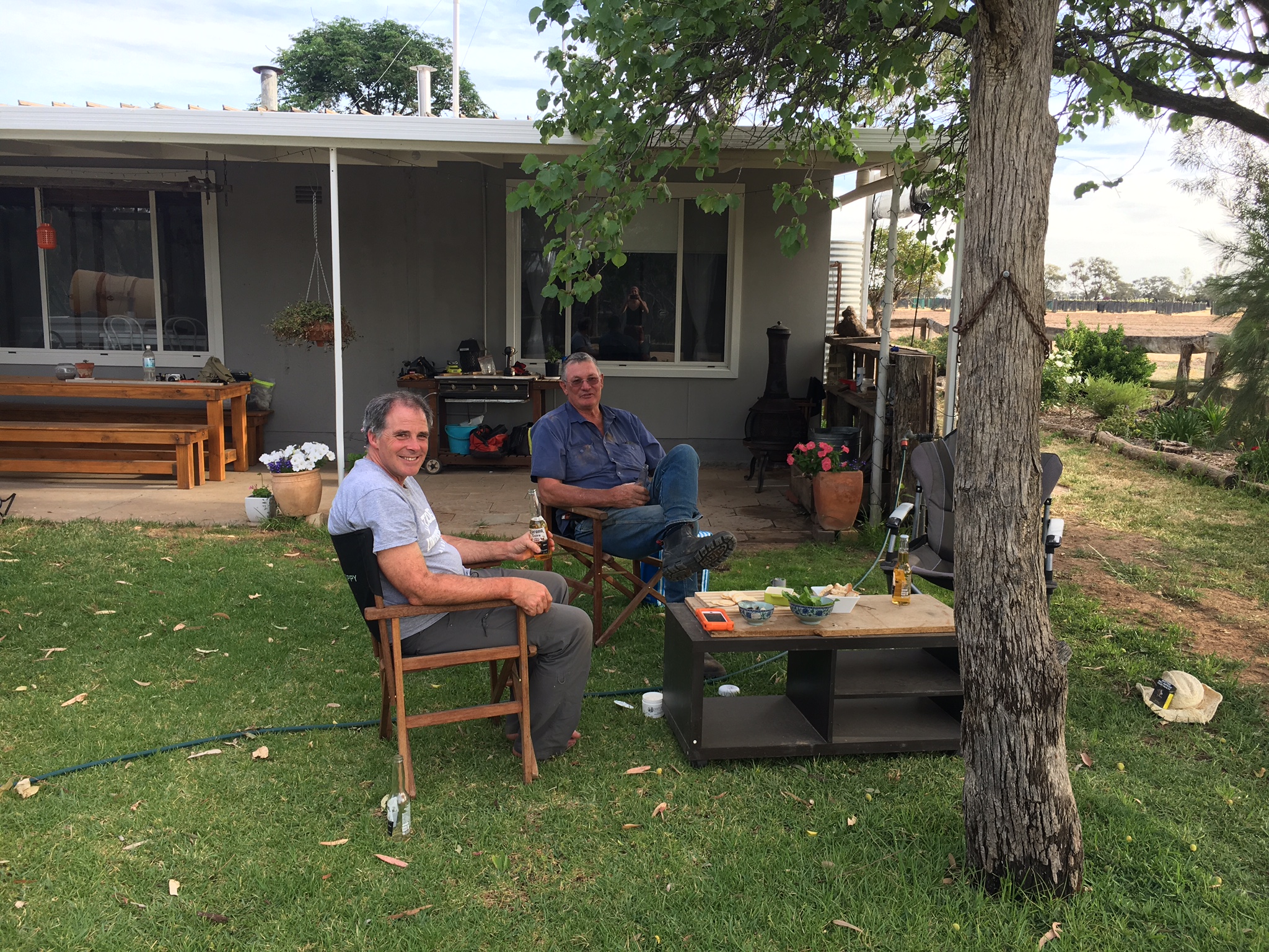
Over lunch I called into Meilman Station. Meilman was settled around 1850 and has been run by the Gorman family since the 1920’s. After serving me a hearty lamb roast sandwich, Andy brought out some of his research into local history, including old newspaper articles and photos. One of the photos showed the paddle steamer Ruby moored in front of their house in high water in 1931. The sandhill on which their house is built is at close to 3 metres higher than the current high river. High rivers were frequent before the Hume Dam was built in the 1960's. The changing levels shaped the banks until there was a stable angle, bit by bit, year by year. Now with high rivers happening less frequently, the shaping is happening all at once, which is one of the reasons for the bank collapse we are seeing along many stretches of the Murray. Andy's son, Alfred, showed me some great drone footage he had shot of the high river. They had been using the drone to look for some missing sheep. The property stretches all the way to Euston township and includes several lakes and old water course, many of which run once the river is up. This is what makes looking for sheep in these times more difficult, but is also what makes the understanding of landholders like the Gormans such a valuable resource. Over time I would like to get in contact with as many river landholders as possible and ask them how they see the river has changed, what they think the issues are and what the causes might be.
Meilman Station ahead.
Reminiscences of a pioneer - Edmund Morey - A bush Christening. Morey wrote a number of articles. These are searchable on Trove and held in the National Library, Canberra ( Edmund Morey - squatter, Euston N.S.W., 1846). Also part of the Balranald Euston Tooleybuc History Project, Country Areas Program, North West Riverina, Schools Commission, 1984 - Frontier and pioneer life - 18 pages. Here is a record of the 14 entries Edmund Morey wrote about life as a pioneer on the Murray River.
Paddlesteamer Marion loading wood at Mielman Station in the 1931 flood. Gorman family.
After Meilman I made for a sandhill the Gormans had told me about, just after invincible bend. In this area the river seems to be doing its old trick of meandering around inside the ancient meanders. This leads to a lot of hairpin bends. During high rivers like this, the river flows straight through the forest rather than around the bends, so instead of great current, I had a lot of areas of dead water. In one of these places I came across what I thought at first was a very odd looking snake. It turned out to be a blue tongue lizard attempting to cross the river. It had blown up its abdomen with air, making it look a bit like a balloon animal. To make headway it wiggled from side to side and tried to do things with its feet as well. Nothing was happening quickly, but it made it across. Lucky there were no whistling kites in the area.
YouTube: Blue tongue lizard swimming across the river. It seems to have filled itself up with air (swallowed, or filled its lungs?). Most other lizards sit low in the water when swimming. I kept my distance, allowing it to cross safely.
Some movement in the water once again...
YouTube: This cutting this is so large that it is as wide as the main river channel I will take the original channel though because I am interested in the comparison between the current state and how the river looked in the 1800's so this is the channel I'll be taking. The river channel I'll be following the original channel is still wider but you can see in high water conditions like this that most of the river is flowing through the cutting.
The still air today was great for both photography and recording bird call. There were perfect reflections and the sounds seemed to be magnified by the forest. The most beautiful call was from a butcher bird, whose whistling call defies its rather nasty habit of impaling its prey on spikes. The cockatoos were in pairs and small groups, nesting communities. They cause quite a problem for local fruit growers and the almond plantations in the area which they see as a gifted food source. Locals say that the flocks in summer have to be seen to be believed.
Near Narcooyia Creek
There looks like there has been a fire through here with charring on the base of some of the trees and epicormic growth up much of the trunks.
Just around the corner from where I was to make camp, I came across a boat coming the other way. There aren’t many boats on the water these days, so we came together and had a chat. Father and daughter, Barry and Jess were just giving their boat a bit of a run after a winter’s rest. Jess handed over a stubby. Barry had heard one of my interviews on the ABC and asked if I was that person. They invited me to stay at their river holiday home, which is where I am now. Again lucky and amazed at the generosity of the people around me. We finished the day off with a few more beers and swapping river stories. Everyone has their story and I want to hear them. There is always something to learn. Barry says that the cockatoos are a big issue in this area. They feed on the almonds and fruit trees. He says that flocks have never been bigger and that they are causing real issues for many trees, whether they be on private property or where they roost in the forest. Barry wanted to emphasise how many things are going well with the river, saying that we only hear the doom and gloom stories. Salinity he says, has never been lower and water is reaching the mouth of the river once again. We all know stories of where things have gone wrong, but its important to reflect on what works as well.
First sign of the Avery's boat... the first boat I have seen on the water since around Gunbower...
YouTube: Coming into Invincible Bend just passed 1158 floodplain River Red Gum forest I've just met Barry and daughter, Jess in that boat and they have invited me to stay in their place have a night how nice is that! This is Invincible Bend.
Barry Avery at Little River Cottage, Invincible Bend.
Tomorrow I make for Robinvale, where I will stock up on supplies.
 With only a short run into Robinvale today, I took time for a cuppa and a good chat with Jess, who had turned up for another day’s work at the farm. She brought in two avocados, one of which made a lovely lunch out on the water. It was a perfect day for paddling, no wind, clear skies and river landscape.