Showing posts with label Aboriginal history. Show all posts

Murray River Paddle 2016 Day 25 Yungera Station to Invincible Bend Nov 9

Yungera to Tol Tol


Sunrise, Yungera Station, Boundary Bend, Victoria

Yungera Station

Yungera Station: pulling my fully laden boat to the river.

Yesterday I passed a major milestone. Just before Tala Rocks, the only known stone fish trap on the Murray that remains today, I passed the point where I had paddled 1000 km since beginning at the Hume Dam about four weeks ago. If you take away days set aside for organisation, rest and time with family, that's close to an average of 50 km a day, which is the target I set myself given the necessary delay to the beginning of the trip caused by major flooding in the Upper Murray.

YouTube: Approaching the 1200 km mark just after Yungera Station (morning bird call).


Overbank flow through blackbox and river reg gum woodland, just after Yungera Station. Saltbush and Exocarpus understory.


YouTube: Between 1194 and 1192 opposite the Yungera Island just passed a big area flooded Black Box where where the river and travels more through the forest then it does down its channel... leading to pretty much next to no current in the bends... picking up slightly now ...maybe doing one kilometre an hour ...that area of box Forest is really quite special with trees over 1 m in diameter and and many canoe trees amongst them ...in one spot I counted about five canoe trees in about 200 m.

In that time the river has changed from looking like a mountain stream, with the hills bordering its catchment clearly visible on either side, to a broad meandering river with 6 km long bends. Above Yarrawonga the Murray was confined to its ancient river bed, regularly flooding and changing course in its narrow valley. Blocked by an uplifting of the earth's crust between Echuca and Deniliquin, it was forced out, split into two rivers, which rejoined, flowing back into the ancient channel 400 km later. It has passed through two giant Redgum forests, the first built on sediment dropped when, blocked by the uplift, the Murray formed a huge lake, and the second, the remnants of a delta where it used to flow into the inland sea that the explorers sought but never found because they were 30 million years too late. Now I am paddling under that sea. No longer covered by waves, I am in the arid zone. Whilst the red gums remain, black box is becoming more common. The silver wattles have been replaced by River Myall and Saltbush and Lignum line the banks. The salt left in the soil beneath the surface by the sea continues to challenge both people and nature. How they cope with this will be part of the story of the next 1,000 km.


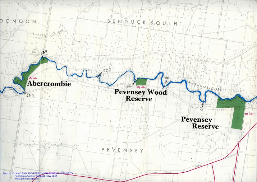
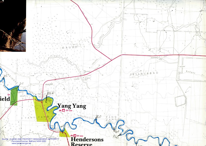
Since the Wakool Junction, the river channel has increased dramatically in width. The parts of the river which flowed Northward around the Cadell Tilt have rejoined and flow is notably stronger. Once again, the Murray is and its floodplain are contained within the channel of the much larger and more powerful stream that existed here in ancient times. The high banks are visible as red cliffs when the river reaches the edge of this corridor.

In the place that this photograph was taken the flow in the river channel has almost stopped, with most of the flow taking the shortest possible route through the forest. This means that there is only current in those sections of the river which run the same direction as the water is flowing. Current speed varies from zero to seven kilometres per hour. In this photograph water is flowing slowly out of the forest and into the river channel.


YouTube: Yungera State Forest beautiful old gums... I've just passed some High ground back here... The High ground tends to be on the outside of the bends it's not surprisingly really has the river is always forming new lower ground on the inside of the bends... meaning that the High ground, the oldest ground built-up through sediment deposition... floodplain sediments or aeolian Sandhill sediments and this is usually where you will find your Black Box ...not surprisingly ...so outside of the bends and usually at the start of the bends you'll find this fellow, Acacia stenophylla with its long thin dark green leaves... and the peak usually not the end and your find Black Box on the outside of the bends and Red Gum floodplain forest on the inside of the bends and immediately downstream on the benches.

Round Yungera Island, so much of the rivers water is flowing directly through the forest that there is next to no current at all. It makes for a pretty picture through. When the light is right, the forest floor sparkles as the ripples from the flow catch the sunlight. Slow flows through the forest create areas of blackwater. I'm yet to see fish kills resulting from it in this area, however it could be that these have been caught in the forest debris. Now, after 4 weeks, I seem to have old caught up with the flood pulse down the Murray. Floods travel like long waves down rivers. The pressure of the wave causes the water to rise even before the flow does. Both are slowed down by the forests. They absorb the flood pulses, protecting those areas downstream and release it slowly, a bit like a mountain spring. This is why high rivers downstream of forests last longer than those upstream. From here on the Murray sticks more to its channel and both the changes in height and flow should be more predictable.

Old Black Box with Saltbush and Lignum understory on the outside of a bend.


Organic matter stranded in an eddy amongst vegetation (Saltbush, Lignum and River Myall) at the bank top NSW, forming a thick mat on the surface for the first metre away from shore.


Right at the peak of the flood wave... Rising flood waters spreading through a Black Box woodland at Boundary Rocks, opposite Cod's Head Reef Campsite, Yungera Island.

At Boundary Rocks I pulled up for a short break. There, the most enormous whirlpools visibly sucked down the surface of the river by up to 10 cm and have a diameter of up to 5 m. Some of them appear suddenly. I took care to stay well away. They are caused by the way the current flows over the rocks below them. We tend to think in two dimensions when it comes to water, but movement occurs in three. The swirls caused by snags and rocks include currents that come to the surface, creating boils and others that go down. When these are extreme they cause whirlpools. Its part of what makes some parts of rivers quite dangerous. The Murray seems so tame, but it has its traps. It is, after all, a wild river. On the shore I can see the waters edge gradually creeping millimetre by millimetre further, or is it receding, when you're at the peak it's hard to tell.

Dragonfly resting on my camera.


Over lunch I called into Meilman Station. Meilman was settled around 1850 and has been run by the Gorman family since the 1920’s. After serving me a hearty lamb roast sandwich, Andy brought out some of his research into local history, including old newspaper articles and photos. One of the photos showed the paddle steamer Ruby moored in front of their house in high water in 1931. The sandhill on which their house is built is at close to 3 metres higher than the current high river. High rivers were frequent before the Hume Dam was built in the 1960's. The changing levels shaped the banks until there was a stable angle, bit by bit, year by year. Now with high rivers happening less frequently, the shaping is happening all at once, which is one of the reasons for the bank collapse we are seeing along many stretches of the Murray. Andy's son, Alfred, showed me some great drone footage he had shot of the high river. They had been using the drone to look for some missing sheep. The property stretches all the way to Euston township and includes several lakes and old water course, many of which run once the river is up. This is what makes looking for sheep in these times more difficult, but is also what makes the understanding of landholders like the Gormans such a valuable resource. Over time I would like to get in contact with as many river landholders as possible and ask them how they see the river has changed, what they think the issues are and what the causes might be.

Meilman Station ahead.

Reminiscences of a pioneer - Edmund Morey - A bush Christening. Morey wrote a number of articles. These are searchable on Trove and held in the National Library, Canberra ( Edmund Morey - squatter, Euston N.S.W., 1846). Also part of the Balranald Euston Tooleybuc History Project, Country Areas Program, North West Riverina, Schools Commission, 1984 - Frontier and pioneer life - 18 pages. Here is a record of the 14 entries Edmund Morey wrote about life as a pioneer on the Murray River.

Paddlesteamer Marion loading wood at Mielman Station in the 1931 flood. Gorman family.

After Meilman I made for a sandhill the Gormans had told me about, just after invincible bend. In this area the river seems to be doing its old trick of meandering around inside the ancient meanders. This leads to a lot of hairpin bends. During high rivers like this, the river flows straight through the forest rather than around the bends, so instead of great current, I had a lot of areas of dead water. In one of these places I came across what I thought at first was a very odd looking snake. It turned out to be a blue tongue lizard attempting to cross the river. It had blown up its abdomen with air, making it look a bit like a balloon animal. To make headway it wiggled from side to side and tried to do things with its feet as well. Nothing was happening quickly, but it made it across. Lucky there were no whistling kites in the area.

YouTube: Blue tongue lizard swimming across the river. It seems to have filled itself up with air (swallowed, or filled its lungs?). Most other lizards sit low in the water when swimming. I kept my distance, allowing it to cross safely.


Some movement in the water once again...

YouTube: This cutting this is so large that it is as wide as the main river channel I will take the original channel though because I am interested in the comparison between the current state and how the river looked in the 1800's so this is the channel I'll be taking. The river channel I'll be following the original channel is still wider but you can see in high water conditions like this that most of the river is flowing through the cutting. 

The still air today was great for both photography and recording bird call. There were perfect reflections and the sounds seemed to be magnified by the forest. The most beautiful call was from a butcher bird, whose whistling call defies its rather nasty habit of impaling its prey on spikes. The cockatoos were in pairs and small groups, nesting communities. They cause quite a problem for local fruit growers and the almond plantations in the area which they see as a gifted food source. Locals say that the flocks in summer have to be seen to be believed.


Near Narcooyia Creek


There looks like there has been a fire through here with charring on the base of some of the trees and epicormic growth up much of the trunks.


Just around the corner from where I was to make camp, I came across a boat coming the other way. There aren’t many boats on the water these days, so we came together and had a chat. Father and daughter, Barry and Jess were just giving their boat a bit of a run after a winter’s rest. Jess handed over a stubby. Barry had heard one of my interviews on the ABC and asked if I was that person. They invited me to stay at their river holiday home, which is where I am now. Again lucky and amazed at the generosity of the people around me. We finished the day off with a few more beers and swapping river stories. Everyone has their story and I want to hear them. There is always something to learn. Barry says that the cockatoos are a big issue in this area. They feed on the almonds and fruit trees. He says that flocks have never been bigger and that they are causing real issues for many trees, whether they be on private property or where they roost in the forest. Barry wanted to emphasise how many things are going well with the river, saying that we only hear the doom and gloom stories. Salinity he says, has never been lower and water is reaching the mouth of the river once again. We all know stories of where things have gone wrong, but its important to reflect on what works as well.


First sign of the Avery's boat... the first boat I have seen on the water since around Gunbower...

YouTube: Coming into Invincible Bend just passed 1158 floodplain River Red Gum forest I've just met Barry and daughter, Jess in that boat and they have invited me to stay in their place have a night how nice is that! This is Invincible Bend.


Barry Avery at Little River Cottage, Invincible Bend.
Tomorrow I make for Robinvale, where I will stock up on supplies.

Lowbidgee: Day 2: Pevensey Station - Maude (61km).

These maps show the area I paddled through on this day. The river was broad and although there were many snags, few blocked passage down the river. Like much of the Lowbidgee, this is the realm of the fishing boat, with shacks hinting at an enduring relationship. Steep banks of gray mud and river red gums front sparsely settled agricultural land.

Mike Bremers: Murrumbidgee Canoe Trip 1995-2008
Mike Bremers: Murrumbidgee Canoe Trip 1995-2008


Waiting for the day to warm up a little and tweak the places that I put things, so that it made more sense, I left my beach campsite opposite the seemingly abandoned Eulalie station and begun my paddle at about 8:45am. There was a light breeze, but despite the cool temperatures of early morning, enough sunshine to keep warm.

Overhanging branches frame the river.
Old and new ways of powering water pumps.

For those paddlers who might follow me, I noticed a potentially good campsite on the high bank after Pevensey Wood Reserve, including a clay bank to land on and low trees for shade.

Many banks are heavily eroded by stock accessing the water. In places there is not a blade of grass, shrub or twig for hundreds of meters due to their ever changing tracks and the fine crumbly nature of the soil. Heavy cattle sink up to a metre into the mud as they struggle down the river bank, causing it to lose its structure. Sheep do not penetrate the soil as far, but in their struggle up the banks loosen and cause soil to tumble into the river. It the first case the banks become a quagmire, in the second dry. In both vegetation and topsoil is removed continually.

Environment Victoria's campaign focus in 2014 is to restrict stock access to river banks, suggesting that watering points be provided above the banks. The aim is to reduce erosion and the sedimentation that results from it, the amount of fecal pollution and dead livestock in our waterways. Dead animals were a feature of this part of the Murrumbidgee. It was not pretty. For this reason, I took as much fresh water from towns with me as possible, and when I had to fill up from the river, either made sure that it was boiled for at least 5 minutes, or had been properly sterilised using purification tablets. The EPA suggest that in some areas of Australia, that there is a culture of dumping. That did not seem to be the case here. The animals were equally a mix of cattle, sheep, kangaroos, pigs, deer and even an echidna. I think that the animals either became stuck on snags, in the mud, or died after gunshot wounds from hunting. In the case of the deer, their antlers had become entangled whilst jousting. I have never witnessed erosion from stock on the scale I have seen it in the lowbidgee. It has given me new respect for the many landholders who protect their environment and have done so for hundreds of years, and those people who are pushing that such actions become the norm, indeed, expectations.


Murrumbidgee Beach

Between Pevensey Wood Reserve and Abercrombie there is SOS reception only. I saw a healthy young Wedge Tail Eagle take off from its meal amongst the trees and fly ahead.

As the river heads SE once more after Abercrombie, the breeze picks up again. There is a landing strip and fisherman's shack which actually looks liveable, it has a solar panel and antennas - perhaps it's something to do with the landing strip. Two big pumps are a welcome navigational confirmation just before you get to this point. Still no reception other than SOS. Interestingly enough, the GPS on my phone works.

Slab fences are common along the Murrumbidgee.
A tangle of roots and snags.
When they say pump they mean it, the pump downstream of Abercrombie is huge.

Only occasional reception from now until Maude. Reached Mike Bremers campsite just before Toongabie station, 64.8 km on the map. Reception very patchy.

Saw another white bellied sea eagle this morning. An immature one with a wing-span of about 1.5 metres (adults can have up to 2.2 metres) and the speckled mottled plumage that makes me think it is still in its awkward teenage phase. Couldn't hear it as it flew. That makes four so far today. By the end of the day, this number increased to six. That's more than I have seen in my 50 years on this planet. I found out that the White Bellied Sea Eagles range extends all the way from India, through South East Asia and into Australia. They are rare in Victoria and threatened in NSW and South Australia. White bellied sea eagles inhabit coastal areas, but have been known to fly thousands of kilometres up rivers. Here, on the Murrumbidgee, I was over 1,000 kilometres inland. It is amazing how far these birds have flown to breed. They usually have two young, but are known to abandon their nests if there is too much disturbance from humans. This would explain why there are so few along the main channel of the Murray, but plenty in the quieter regions within the basin. It was a great to see so many with young.


Toogimbie Station. Although it is very quiet on the river, my map tells me that I am often passing stations.
Toogimbie Station was first taken up by squatters in the mid 1800's and became one of the major holdings around Hay. It was then known as Lang's Crossing. The station includes aboriginal burial grounds with remains dated as at least 15,000 years old, middens, campsites and scar trees. It was purchased by the Nari Nari Aboriginal Tribal council in 2000 who are now going about restoring the natural balance of the area, by controlling weeds and feral animals and undertaking revegetation projects. 
Effects of changes in water availability on Indigenous people of the Murray-Darling Basin: a scoping studySue Jackson, Brad Moggridge and Cathy Robinson. Report to Murray Darling Basin Authority, 2010. Walking with the Nari Nari. Aboriginal Heritage. Toogimbie Burial Ground. NSW Department of Heritage and Environment. Indigenous protected areas. Toogimbie Station. There are.... freshwater, seasonal wetlands support many local plants and animals—a 2002 fauna survey found 86 different species including 55 bird, 18 mammal, 11 reptile and two frog species. Tree and shrub species include river red gum, black box and smaller species such as boree or weeping myall, cooba, dillon bush and nitre goosefoot.
At 71 km now. Big flock of pacific black ducks keep settling then flying ahead of me. Seen several pairs of Pelicans, as well as white faced herons and some self important galahs. First wood duck chicks are out and about, parents flying ahead and then doubling back once I am far enough away, young ones diving if I get too close. A white bellied sea eagle would have to be a silent flyer to pluck one from the water, they are pretty fast! No sulfur crested cockatoos so far.. perhaps the crops planted around here are not so attractive to cockatoos. I suspect those big pumps that I've been seeing throughout the day might be feeding rice fields. Cockatoos might not like having wet feet. Most are not operating at the moment, but if they were all at once, there would not be much current left over for anything else I suspect.

I have come across the odd, and sometimes elaborate fishing shacks, some even with air-conditioning and windows. Passing under an overhead power line, there is a sign which warns yachts that clearance varied with river level. Somewhat optimistic to sail a yacht here I would have thought. At 83.4 km a fishing and camping reserve is marked on the map. Hardly seems different from the forest on farmers land, but this patch is designated for public use. Can only see a fishing sign on the map - no name.


Red gum roots crawl across the surface of the bank, whilst the remains of a pier can be seen in the background.


There has been a lot more farmland today. Some of those farmers have removed almost all of the trees. In those places, strong gusts of wind buffett he river and all that is on it. I keep an eye on the branches moving in the tall red gums that tower over me. I really notice the absence of forests the southern bank in this part of the river. Often it is too high for red gums,, however when left to itself, a box woodland seems to grow. Sometimes I see box an lignim, meaning that the drainage is poor and hinting at the presence of s swamps - at least seasonally.

First BBQ / Fishing barge I have seen on the Lowbidgee.
Old pump station with brick foundations.
Eroded bank (stock access) contrasts natural bank (no stock access).
Pile of snags heaped up on the outside of the bend show the strength of the current when the river is up.


It was a difficult day, with not much current compared to the Murray, no training on my part and a very heavy boat (with the battery solar panel and all that extra food - I think I could travel four weeks with the amount of veggies and fruit that I have). Next trip, I will make sure I don't over cater. I paddled for 8 hours straight in order to get to Maude with enough time to pull the boat out (for the weir and set up camp). 61 km today, making a total of 106 km in two days. I hope to average 50 km a day in order to make it to Boundary Bend in the time I have.


Wedge Tailed Eagle nest.

So far the weirs have really not been canoe friendly. Added to that both Maude and Hay were two metres lower than usual. I think they may be flushing the river and draining the wetlands to help fight carp. For me it means really steep banks, with a heavy boat it is difficult. Whether the river is faster than usual or not is a matter of some dispute amongst the locals. When I was about to launch my ear was all but chewed off by an elderly gentleman walking his dog. He said that he had never seen it so fast at Hay. I strained my eyes, hoping to see what he meant...nope, no ripples... nope, no slingshot effect as I left. The current must be even slower most of the time in Hay. Down at Maude, I thought the current was pretty good - particularly in comparison to Hay, but here the locals say that it usually about double what it was today. I guess I am just glad that there is a current. The lowered weir pools mean that the banks are muddy and steep. The local councils seem to plan only for high water, and despite advertising the Murrumbidgee as a canoeists paradise (Murrumbidgee Canoe Trail), don't seem to be doing much to make it one in terms of infrastructure.
Approaching Maude in the afternoon sun.


I asked people (I met people)... fishermen camping for the weekend... occupying their fishermen's shacks or in family group tent towns... No one could tell me... Finally (as I had beached myself on a mud bank on the southern side of the river, a young couple in a tinny suggested I use the mooring they we're going to use to get to the pub... I followed their lead with the added bonus that they helped me up the bank - no mean feat - you'll see what I mean when I am able to show you a photo.

Maude shop. 
Once camp was set up, I walked into town for a look. Maude is almost a one horse town. I went to the general store mostly out of interest. It is the post office, 'supermarket', cafe, fishing supplies and petrol station. When you walk in you can see the TV in the family lounge as only a half drawn curtain separates the two areas. Other than the muddle of merchandise, the first thing that struck me was a four year old who was following his toddling sibling. Don't look, he said, he is only wearing a nappy. For some reason the older sibling thought that in the cause of decency, he should hitch his younger brothers nappy higher. Unfortunately, this caused the nappy to fall completely off! In this confusion out came dad. He tried to serve his customer and send his children back behind the curtain. Unfortunately the attempt at multitasking failed. The younger child, rejoicing in his notoriety, was doing laps in front of the fridges and the older one fully appreciated the spectacle, shrieking in time with his younger brother. I ordered a pack of AA batteries and a coke. The owner spied the empty water bottles I was carrying and gave me a tap handle to operate his rainwater tank. If you pass by this way, call in at the shop, you won't be disappointed. Further down the road (Maude has two) is a well built tin shed with a large sign proclaiming it to be the Maude War Memorial Hall. On the edge of town is the pub. Very popular with fishermen it seems - though the climb over the fence on the way back to the boats in the dark is not recommended.

It has been nice to see people today. The number of people camping on the banks increased as I got closer to town. Other than these people, I have only seen one boat since leaving Hay two days ago. Earlier today I paddled past an esky with two fishing rods next to it. Despite the owner being nowhere in sight, I almost jumped out of the boat with excitement.

My favourites were the young fishermen and his well oiled and wet older friend (he had fallen in the river), as they helped me enormously with moving my boat, and the tired shop owner.