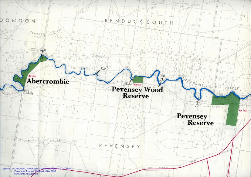
These maps show the area I paddled through on this day. The river was broad and although there were many snags, few blocked passage down the river. Like much of the Lowbidgee, this is the realm of the fishing boat, with shacks hinting at an enduring relationship. Steep banks of gray mud and river red gums front sparsely settled agricultural land.


Waiting for the day to warm up a little and tweak the places that I put things, so that it made more sense, I left my beach campsite opposite the seemingly abandoned Eulalie station and begun my paddle at about 8:45am. There was a light breeze, but despite the cool temperatures of early morning, enough sunshine to keep warm.
 |
| Overhanging branches frame the river. |
 |
| Old and new ways of powering water pumps. |
For those paddlers who might follow me, I noticed a potentially good campsite on the high bank after Pevensey Wood Reserve, including a clay bank to land on and low trees for shade.
Many banks are
heavily eroded by stock accessing the water. In places there is not a blade of grass, shrub or twig for hundreds of meters due to their ever changing tracks and the fine crumbly nature of the soil. Heavy cattle sink up to a metre into the mud as they struggle down the river bank, causing it to lose its structure. Sheep do not penetrate the soil as far, but in their struggle up the banks loosen and cause soil to tumble into the river. It the first case the banks become a quagmire, in the second dry. In both vegetation and topsoil is removed continually.
Environment Victoria's campaign focus in 2014 is to restrict stock access to river banks, suggesting that watering points be provided above the banks. The aim is to reduce erosion and the sedimentation that results from it, the amount of fecal pollution and dead livestock in our waterways. Dead animals were a feature of this part of the Murrumbidgee. It was not pretty. For this reason, I took as much fresh water from towns with me as possible, and when I had to fill up from the river, either made sure that it was boiled for at least 5 minutes, or had been properly sterilised using purification tablets. The
EPA suggest that in some areas of Australia, that there is a culture of dumping. That did not seem to be the case here. The animals were equally a mix of cattle, sheep, kangaroos, pigs, deer and even an echidna. I think that the animals either became stuck on snags, in the mud, or died after gunshot wounds from hunting. In the case of the deer, their antlers had become entangled whilst jousting. I have never witnessed erosion from stock on the scale I have seen it in the lowbidgee. It has given me new respect for the many landholders who protect their environment and have done so for hundreds of years, and those people who are pushing that such actions become the norm, indeed, expectations.
 |
| Murrumbidgee Beach |
Between Pevensey Wood Reserve and Abercrombie there is SOS reception only. I saw a healthy young
Wedge Tail Eagle take off from its meal amongst the trees and fly ahead.
As the river heads SE once more after Abercrombie, the breeze picks up again. There is a landing strip and fisherman's shack which actually looks liveable, it has a solar panel and antennas - perhaps it's something to do with the landing strip. Two big pumps are a welcome navigational confirmation just before you get to this point. Still no reception other than SOS. Interestingly enough, the GPS on my phone works.
 |
| Slab fences are common along the Murrumbidgee. |
 |
| A tangle of roots and snags. |
 |
| When they say pump they mean it, the pump downstream of Abercrombie is huge. |
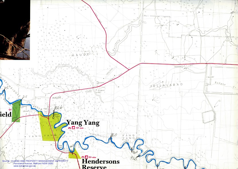
Only occasional reception from now until
Maude. Reached
Mike Bremers campsite just before Toongabie station, 64.8 km on the map. Reception very patchy.
Saw another
white bellied sea eagle this morning. An immature one with a wing-span of about 1.5 metres (adults can have up to 2.2 metres) and the speckled mottled plumage that makes me think it is still in its awkward teenage phase. Couldn't hear it as it flew. That makes four so far today. By the end of the day, this number increased to six. That's more than I have seen in my 50 years on this planet. I found out that the White Bellied Sea Eagles range extends all the way from India, through South East Asia and into Australia. They are rare in Victoria and threatened in NSW and South Australia. White bellied sea eagles inhabit coastal areas, but have been known to fly thousands of kilometres up rivers. Here, on the Murrumbidgee, I was over 1,000 kilometres inland. It is amazing how far these birds have flown to breed. They usually have two young, but are known to abandon their nests if there is too much disturbance from humans. This would explain why there are so few along the main channel of the Murray, but plenty in the quieter regions within the basin. It was a great to see so many with young.


 |
Toogimbie Station. Although it is very quiet on the river, my map tells me that I am often passing stations.
Toogimbie Station was first taken up by squatters in the mid 1800's and became one of the major holdings around Hay. It was then known as Lang's Crossing. The station includes aboriginal burial grounds with remains dated as at least 15,000 years old, middens, campsites and scar trees. It was purchased by the Nari Nari Aboriginal Tribal council in 2000 who are now going about restoring the natural balance of the area, by controlling weeds and feral animals and undertaking revegetation projects.
Effects of changes in water availability on Indigenous people of the Murray-Darling Basin: a scoping study. Sue Jackson, Brad Moggridge and Cathy Robinson. Report to Murray Darling Basin Authority, 2010. Walking with the Nari Nari. Aboriginal Heritage. Toogimbie Burial Ground. NSW Department of Heritage and Environment. Indigenous protected areas. Toogimbie Station. There are.... freshwater, seasonal wetlands support many local plants and animals—a 2002 fauna survey found 86 different species including 55 bird, 18 mammal, 11 reptile and two frog species. Tree and shrub species include river red gum, black box and smaller species such as boree or weeping myall, cooba, dillon bush and nitre goosefoot.
|
At 71 km now. Big flock of
pacific black ducks keep settling then flying ahead of me. Seen several pairs of
Pelicans, as well as
white faced herons and some self important
galahs. First
wood duck chicks are out and about, parents flying ahead and then doubling back once I am far enough away, young ones diving if I get too close. A white bellied sea eagle would have to be a silent flyer to pluck one from the water, they are pretty fast! No
sulfur crested cockatoos so far.. perhaps the crops planted around here are not so attractive to cockatoos. I suspect those big pumps that I've been seeing throughout the day might be feeding rice fields. Cockatoos might not like having wet feet. Most are not operating at the moment, but if they were all at once, there would not be much current left over for anything else I suspect.
I have come across the odd, and sometimes elaborate fishing shacks, some even with air-conditioning and windows. Passing under an overhead power line, there is a sign which warns yachts that clearance varied with river level. Somewhat optimistic to sail a yacht here I would have thought. At 83.4 km a fishing and camping reserve is marked on the map. Hardly seems different from the forest on farmers land, but this patch is designated for public use. Can only see a fishing sign on the map - no name.
 |
| Red gum roots crawl across the surface of the bank, whilst the remains of a pier can be seen in the background. |
There has been a lot more farmland today. Some of those farmers have removed almost all of the trees. In those places, strong gusts of wind buffett he river and all that is on it. I keep an eye on the branches moving in the tall red gums that tower over me. I really notice the absence of forests the southern bank in this part of the river. Often it is too high for red gums,, however when left to itself, a box woodland seems to grow. Sometimes I see box an lignim, meaning that the drainage is poor and hinting at the presence of s swamps - at least seasonally.
 |
| First BBQ / Fishing barge I have seen on the Lowbidgee. |
 |
| Old pump station with brick foundations. |
 |
| Eroded bank (stock access) contrasts natural bank (no stock access). |
 |
| Pile of snags heaped up on the outside of the bend show the strength of the current when the river is up. |
It was a difficult day, with not much current compared to the Murray, no training on my part and a very heavy boat (with the battery solar panel and all that extra food - I think I could travel four weeks with the amount of veggies and fruit that I have). Next trip, I will make sure I don't over cater. I paddled for 8 hours straight in order to get to Maude with enough time to pull the boat out (for the weir and set up camp). 61 km today, making a total of 106 km in two days. I hope to average 50 km a day in order to make it to
Boundary Bend in the time I have.
 |
| Wedge Tailed Eagle nest. |
So far the weirs have really not been canoe friendly. Added to that both Maude and Hay were two metres lower than usual. I think they may be flushing the river and draining the wetlands to help fight carp. For me it means really steep banks, with a heavy boat it is difficult. Whether the river is faster than usual or not is a matter of some dispute amongst the locals. When I was about to launch my ear was all but chewed off by an elderly gentleman walking his dog. He said that he had never seen it so fast at Hay. I strained my eyes, hoping to see what he meant...nope, no ripples... nope, no slingshot effect as I left. The current must be even slower most of the time in
Hay. Down at Maude, I thought the current was pretty good - particularly in comparison to Hay, but here the locals say that it usually about double what it was today. I guess I am just glad that there is a current. The lowered weir pools mean that the banks are muddy and steep. The local councils seem to plan only for high water, and despite advertising the Murrumbidgee as a canoeists paradise (
Murrumbidgee Canoe Trail), don't seem to be doing much to make it one in terms of infrastructure.
 |
| Approaching Maude in the afternoon sun. |
I asked people (I met people)... fishermen camping for the weekend... occupying their fishermen's shacks or in family group tent towns... No one could tell me... Finally (as I had beached myself on a mud bank on the southern side of the river, a young couple in a tinny suggested I use the mooring they we're going to use to get to the pub... I followed their lead with the added bonus that they helped me up the bank - no mean feat - you'll see what I mean when I am able to show you a photo.
 |
| Maude shop. |
Once camp was set up, I walked into town for a look. Maude is almost a one horse town. I went to the general store mostly out of interest. It is the post office, 'supermarket', cafe, fishing supplies and petrol station. When you walk in you can see the TV in the family lounge as only a half drawn curtain separates the two areas. Other than the muddle of merchandise, the first thing that struck me was a four year old who was following his toddling sibling. Don't look, he said, he is only wearing a nappy. For some reason the older sibling thought that in the cause of decency, he should hitch his younger brothers nappy higher. Unfortunately, this caused the nappy to fall completely off! In this confusion out came dad. He tried to serve his customer and send his children back behind the curtain. Unfortunately the attempt at multitasking failed. The younger child, rejoicing in his notoriety, was doing laps in front of the fridges and the older one fully appreciated the spectacle, shrieking in time with his younger brother. I ordered a pack of AA batteries and a coke. The owner spied the empty water bottles I was carrying and gave me a tap handle to operate his rainwater tank. If you pass by this way, call in at the shop, you won't be disappointed. Further down the road (Maude has two) is a well built tin shed with a large sign proclaiming it to be the Maude War Memorial Hall. On the edge of town is the pub. Very popular with fishermen it seems - though the climb over the fence on the way back to the boats in the dark is not recommended.
It has been nice to see people today. The number of people camping on the banks increased as I got closer to town. Other than these people, I have only seen one boat since leaving Hay two days ago. Earlier today I paddled past an esky with two fishing rods next to it. Despite the owner being nowhere in sight, I almost jumped out of the boat with excitement.
My favourites were the young fishermen and his well oiled and wet older friend (he had fallen in the river), as they helped me enormously with moving my boat, and the tired shop owner.


No comments:
Post a Comment