A journal of canoe expeditions along the rivers of Australia's Murray Darling Basin using photographs, stories and information to highlight the beauty, challenges and history of these rivers and the communities they flow through.
Showing posts with label Murrumbidgee Junction. Show all posts
Showing posts with label Murrumbidgee Junction. Show all posts
My camp was at the 48.7km mark (52km by GPS) on this map. I got away early and soon passed Canally Station (which, like Pevensey Station, has a paddle steamer named after it).
The river twists and turns in this lower section. Sturt, exasperated, complained that the river followed every point of the compass at some stages (around the 50 and 80 km mark on these maps).
It had been a cold night, but I kept warm in my sleeping bag by pulling the hood down over my head until it resembled a frog. Out of the slit between the hood and the body of the sleeping bag I could breath and catch a glimpse of light. I feel claustrophobic when all the drawstrings are pulled tight, fearing that I could not get out in a hurry, or that the strings will get wrapped around my neck and strangle me, but with this arrangement the hood kept me warm without the feeling of being trapped. Other than the normal twists and turns associated with sleeping on the ground, I slept well. So well, that I slept through the first alarm that went off in the morning and it was only by chance that I awoke 20 minutes later at 5:50am to find the birds in full chorus and the light strong enough to make out everything without a torch. I packed methodically and efficiently, so that in 20 minutes, all of my gear was beside the boat, ready for stowing away.
Morning light on my camp near Canally station.
I made breakfast, dressed in my paddling gear (which had dried overnight), secured the solar panel and the clips to my battery behind my seat in the cockpit. The log beside my boat meant that I could get in without muddy feet, which was nice. I pushed off and than poked around till I found a way out between the saplings, eating breakfast gradually as I eased into padding. The morning was the coldest yet, only 3 degrees, so I was well rugged up, with a heavy neoprene spray deck, gortex jacket and beanie. I used a cut up stubby holder to stop water running down my sleeves and into my top. They worked surprisingly well.
The PS Canally: named after Canally Station and now under restoration in Morgan S.A. was known as the 'greyhound of the river' ,however not without controversy, as this report on a race between it and the PS Alexander Arbuthnot in 1913 shows.
3/9/1913 - Riverina Recorder Steamer Rivalry - The Barham 'Bridge' says that much rivalry exists between the connections of the Arbuthnot and the Canally as to which is the fastest boat and in a speed trial recently the owners of the latter claimed that their vessel was superior in this direction. The engineer of the Arbuthnot could not develop the speed which he knew his boat to be possessed of, and on examination of the smoke box it was discovered that some individual (presumably a rival) had dropped a brick down the funnel. The draught from the furnaces being considerably interfered with in consequence. Given a fair trial the crew of the Arbuthnot reckon they can beat anything on the river. (Source: Friends of the Canally).
The river is always changing...
in the morning, the sunlight almost invites you to discover each bend...
On the water there was a steady current of between one and one and a half kilometres an hour, seemingly faster in some places and slower in others. Reception was good throughout the day, as I moved out from the Murrumbidgee floodplain and into the Murray Darling Basin depression. The difference between paddling down the Murray and the Lower Murrumbidgee is that in the later you are paddling through an established ephemeral wetland. When the ‘bidgee floods (which naturally happens with the snow melt in September and October) it runs into parallel overflow channels which run for hundreds of kilometres – some for as far upstream as Narrandera. These then feed into smaller channels and lake systems. Some of these are used again today to maintain the natural landscape and environment in a healthy condition, which is why there are so many sea eagles here: their hunting is not confined to the river channel, but includes the lakes and wetlands around it. As I neared the Murray the last of these re-entered the river and the landscape became drier. The air smelt different, drier and the species of birds changed, there were more cockatoos, corellas and galahs and there were less eagles, kangaroos and emus. With every paddle stroke I was nearing the Murray – all my senses told me so.
which may open up into great straights...
or a tangle of snags...
The map was less convincing. The river twists and turns the whole way from Hay to the Murray River, but in the last section of the Lower ‘bidgee it seems to put in a special effort, as if it was saying ‘please let me do my own thing a little longer’. There are two points a little before and after Marnie Station, where the ‘bidgee has straights of a kilometre at every point of the compass, first East, then North, then West, then South. It left Sturt exasperated during his exploration of the river, “…(the river) in its tortuous course, swept round to every point of the compass with the greatest irregularity.”
A plan by Sir John Monash proposing the possibility of irrigation and wetland coexistence.(Yanga Station Display).
Fisherman's shack.
Around Manie Station the snags were particularly bad. About 75 km downstream from Balranald a tree trunk with a diameter of almost a meter, completely blocks the river. I found a gap big enough to let my sea kayak through at the top end of the snag, however at lower water levels this would not have been an option and a portage would have been unavoidable. I avoided portages, because they meant unloading and reloading the boat (probably in the mud). In the next ten kilometers so may tree blocked the river, that I lost count. Most were small enough that I could push through the smaller twiggy branches, duck underneath, or slide over with a run up. On one, however, my run up was not fast enough and I spent some moments with both ends of the boat in the air, like a balance scale. I managed to continue by pushing down onto the snag, lifting my boat in the process. It was impossible to paddle off, or to pull my self over. Those few moments where I was stuck, with my tail rudder slowly catching the current and threatening to turn my boat sideways, seemed much longer than they actually were. My heart beat loudly, adrenalin pushed already tired arms and an exhausted body to go harder than ever seeking a release, which eventually came. The escape feeling must be similar to that in a hunted animal. It takes some minutes to calm down again and labored breathing to blow off all the accumulated carbon dioxide. I wondered how Sturt managed such problems in his whale-boat. Indeed, even in the higher river that he had (“We were carried at a fearful rate down its gloomy and contracted banks.”) he will have had issues with large snags and blockages of debris.
A large tree completely blocking the Murrumbidgee. I was able to slip around in a metre sized gap on te left hand side.
Here, an impressive clay reef stubbornly refuses to be eroded on the outside of a bend in the Murrumbidgee.
I passed five stations today, of which Canally was the first and the prettiest. It was a well maintained, white painted wooden weatherboard building with verandahs on all sides. In front of the house and to one side stood a windmill and a water tank on a tower, providing water pressure for the house. The tower was overgrown with a flowering vine, which gave a sweet scent to the air and would have provided a home to small birds, as well as keeping the tank water cooler in summer. It was from this homestead that I could hear the children’s voices last night. It struck me that those kids would have a good childhood; the place looked cared for and they were surrounded not only by fertile land, but the most beautiful natural environment. Waldara could not be seen easily from the water, only water tanks and farm machinery gave way its presence. Tarana was a well kept large traditional looking station, with large sheds, at least the equal of Yanga Station (now preserved in as part of a National Park further upstream); the only difference was that this one was cared for and still in use.
Succession is a problem on farms (ABC report), many things have to be right for the younger generations to be able to take over from the older. Some manage it: in Yanga Station, one of the signs spoke of a station that had been in the one family for well over a hundred years. In these days of increasing foreign and corporate ownership, it must be a worry of many land-owners that the past and the environment they have cared for will be looked after just as well by the people who follow in their footsteps.
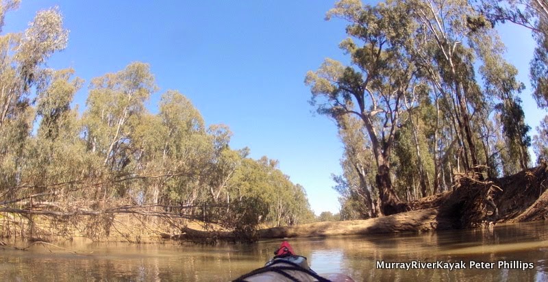
Nearing the junction.
Just before Manie Station, there was a new and narrow cutting, but the water was so shallow here and the possibility of being wedged against the snags at its outlet into the main stream made me decide to be cautious and not take that short cut. There was a fair drop in the river here, I could tell from the difference in water level between the top of the cutting and the bottom. I calculated that in the 400 km I had paddled that the river had dropped around 20m, that is 5cm a kilometer. In the kilometer that this cutting would have saved I noticed about a 20 to 30 cm drop, which means that the river must be pooling behind clay reefs in many other places. The kilometer past Manie station was full of snags and the fast current through here made paddling it like doing a slalom course. It could not be taken slowly. It had to be done at full power to have maximum steerage and the speed to go over small horizontal branches. I did get through. Manie station is set well back from the river. I was able to see tanks, but little else. A later look at Google Earth, confirmed its location, well back from the bank.
In this area, stations tend to be built on areas of red soil, as the pioneers learnt that these areas tend not to be flooded. Weimby, the last station before the Murray was no exception, again, the house cannot be clearly seen, but you will know that you are there when you see the rusty old remains of an old corrugated iron water tank which has been rolled to the river’s edge, along with a collection of other rubbish. It used to be common practice for farmers to dump their old vehicles off the river bank and watch them rust away. It must have been a period of detachment form the environment, when motorization, the lure and power of the combustion engine, made people feel that they did not need the environment, only enough machinery to bend it to their will. Thank God, those days have passed and rubbish dumping on this kind of scale is a rarity now.
Just before the junction I came across three old wooden boats with single cylinder engines. The three gentlemen owner-builders had come together from different corners of Victoria for an outing from Boundary bend and had pulled up for lunch a kilometre up the Murrumbidgee. As I passed them they had just lit a fire for lunch and invited me to join them, however with only a kilometre to go and the knowledge that Ruth was waiting for me, I was in no mood for a long break. It is only possible to travel about 4 to 5 kilometres up the Murrumbidgee in a boat like these before the passage is completely blocked by snags, however even this short foray awakes nostalgia. Enter into the Murrumbidgee and you step into the past, a time when white Australia was young, naive and hopeful, when the whistle of a paddlesteamer meant civilisation and the chance of prosperity, success depended on ingenuity, luck, and the whims of a river fed by storms and snow 1000 km away.
My camp by Canally Station was the end of the pure Lower Murrumbidgee Seasonal Wetland; bits of it reappear now and again, but farmland, with its sheep, goats and cattle are much more prominent. There is a change in the birdlife too. I saw no more of the sea eagles that have been so much a feature of this trip on this day and fewer pelicans. Corellas, cockatoos and galahs became more common, the crowns of the trees bright with their audacious character. The air smelt different too, it was a dry air, that told of drying soil and warned of the approaching summer. It was as though the river had been a playground and here were the realities of life. The ‘bidgee, with all its cheeky character and life was about to enter a river of a whole other scale. The teen was about to meet its parent. The junction was near.
Not that I was keen to end the paddle, but after 8 days and 400km it was great to reach the Murray.
The confluence of the Murrumbidgee and the Murray Rivers. Fishermen seemed to be having quite a bit of luck where the current swirls as the two rivers meet.
It happens suddenly. One last bend to the right, shorter than expected and the grey waters of the ‘bidgee join the green waters of the Murray. Swirls show where their currents meet in an unavoidable embrace. On the opposite bank I see my girl. Ruth has driven, as she always does, hours to meet me. I break into a sprint. A feeling a happiness, relief, satisfaction and privilege run through me. I feel privileged to have paddled the lower ‘bidgee. Not many people seem to have done it in the last few decades. It is the forgotten river, and all the more special for being so. The snags that make it so difficult, also protect it and provide home to so many animals above and below the water. Increasing my pace till my arms ache, I build my speed both as expression of my feelings, to show that I am well and to launch up on the bank on the Victorian side of the Murray. My boat makes a crunching sound as it slides up, over the sand. I release the spray deck and stagger to an upright position, walk to my girl and we hug. The lower ‘bidgee has been a challenge, but worth every kilometer.
Hanging up gear to dry before loading my boat for the trip home to Echuca.
The calm before the storm. What I thought might be heavy vehicles on a highway turned out to be a series of slow moving thunderstorms. Packed up camp quickly and had brekky after 20 km. — at Downstream from Wakool Junction.
This morning I awoke as usual to the sound of bird call that comes with the dawn. I would rather have stayed in the comfort of my sleeping bag a little longer, but I knew that a late start puts pressure on the day. As well as that, I wanted to visit Boundary Bend. That would take some time. So I got up. Everything seemed normal, except that there was a frequent rumbling in the background, like cattle trucks passing over a corrugated road. It happened so often that I thought I must be either near a highway, or a major stock route. I packed up my tent, sleeping bag, mat and all the things I had in my tent, placed them in the boat and settled down to get breakfast ready. One of the things I like about beach campsites is that I can pull the boat up to where I am camping and use it as a seat. It is also much simpler with cooking because everything is there. I have a pretty simple set up, all my camping gear is in the back of the boat and all my food is in the front. Camping gear packed, I sat on the bow of the boat and began to prepare brekky and lunch. The rumbling changed. It got closer. Ok, no truck. The sky darkened alarmingly and a sudden strong wind scattered dry leaves from high in the canopy all across the river and through the air. Not good. Plan change. Action stations. I tipped out the metho I had only just filled into the burner of my trangia and lit it to burn off the rest. Metho leaves food tasting disgusting if you allow it to spill. I hurriedly finished preparing lunch, half a carrot, a chunk of Kraft cheddar processed cheese, a chunk of salami, a tomato and a tube of vegemite; filled up my snack hatch with bananas, peaches in syrup and mixed nuts; donned my raincoat and packed everything away as fast as I could. The lightening was getting closer. Rain would fall any moment and I wanted to keep my gear dry. I just pushed off the shore when the first heavy drops fell.
Trying to get away from thunderstorms is difficult when the river keeps doing snakies.
The rain kept coming, so, nothing to it but to keep on paddling. — at Murray River, near Boundary Bend.
I had not had brekky, but reasoned that I could snack on the way once the rain stopped. I noticed that the thunderstorm was very slow moving and had a notion that I might be able to paddle away from it. If the bends in this area of the river were not so big and if they did not double back on themselves as much as they do, I might have stood a chance. No hope, as soon as I seemed to be paddling away from the storm, the river took me back. Some of the bends around here are 7 kilometres long and when your done with that there is one of a similar size going the other way! So, whether there were several thunderstorms, or whether I just kept paddling with all my might into the same one is beside the point. I was wet on the outside from the rain and wet on the inside from the exercise. About three kilometres from Boundary Bend the rain finally stopped.
I beached my boat by taking a run up at the shore. I like doing this because if I am lucky I can step from my boat onto dry ground and its fun :). The Murray Valley Highway runs through Boundary Bend. After 500 kilometres of virtual isolation and almost only forest, the activity of the highway was quite a contrast. I decided that I could not go dripping wet into a shop and ask for an icy pole. I had to dry off first.
River landscape. — at Murray River, upstream of Boundary Bend.
River landscape. — at Murray River, upstream of Boundary Bend.
River landscape. — at Murray River, upstream of Boundary Bend.
Boundary Bend, where Major Mitchell crossed the Murray.
Reception was excellent, so I used the time it took to dry to upload some photos. I also took a look around. Boundary Bend is not a big place. It is also not as cosy as Tooleybuc. It does have a petrol station and its own street, a dirt track, just off and parallel to the highway. It also has river pole art. This kind of art originated in Mildura (I believe) and consists of painted and sometimes carved bollards from old wharfs. The one in Boundary Bend is of Captain Arch Conners, which is fitting, because he lived here up until his death in 1981 in his home on a bend in the river. He called his home 'Blighty'. Arch Conners was one of the last river boat skippers on the river. He was famous for his knowledge of the river and river lore. He could tell whether a boat was approaching by the way the ducks flew overhead, or that a paddle steamer was ahead from the way the water behaved. He owned many boats in his time, including the Fairy, the Canberra and the Etona. Despite the busy and often frontier nature of the river trade, Arch strove to be a good family man. he kept Sunday free for church and family. As well as having strong moral fibre, Arch was famous for helping stranded families in the Murrumbidgee area in the great floods of 1956. he steamed as far as he could up the Murrumbidgee - no mean feat when it is in flood - and took supplies or rescued stranded families. My father spoke very highly of Arch Conners and interviewed him before writing his first book on paddle steamer history, 'Riverboat Days'. He was also part of a group of people who purchased the Canberra from Mildura, before selling it to the Echuca council back in the 1970's. Another Echuca partnership, including Phill Symons, purchased the Etona. So Echuca has links to Boundary Bend.
Murrumbidgee Junction. This water comes all the way from Thredbo, passing through Canberra, Wangaratta, Hay... — at Murray River, near Boundary Bend.
I walked into 'town' and identified the main street. There was one business there, serving as a post office, take away and restaurant. I wandered in there rather than the flash looking petrol station and was rewarded with not only my icy pole, Big M and a pie, but also some wonderful conversation from the lady who ran the shop. She knew an awful lot about the river. She knew the names of the cuttings and how far away the sand bars were. Peter Garfield (Captain of the Canberra and Emmy Lou in Echuca), told me that there are still Conners in Boundary Bend and that they run the shop. Later I noticed an uncanny resemblance between Arch Conners face on the river pole and in my charts and the lady in the shop. I reckon she was Arch's granddaughter - river royalty. As well as telling me how many people had died on the river and checking that I was aware of all the dangers, she told me that every chance she gets out in her tinny with her husband. They fish, have BBQ's on the beaches and sometimes see how far up the Murrumbidgee they can go. Without prompting, the lady said that she did not work every day, she kept Sundays free.
Arch Connor, river boat captain and I, over looking the place where Sturt crossed the Murray.
Boundary Bend: Main Street. Next to Murray Valley Highway.
Boundary Bend: Other Street.
Original cottage: Boundary Bend.
Two other highlights of the day were seeing the Murrumbidgee junction and the Tala Rocks. The Murrumbidgee is one of Australia's great rivers, yet when it enters the Murray it is not much wider than a stream. It had a good flow though and bolstered the current in the Murray, much to my pleasure. In high river times, paddle steamers traveled over 1200 kilometres up the Murrumbidgee, at least as far as Gundagai. It is hard to imagine that now. The water that flows from the Murrumbidgee is clearer than that of the Murray. The river boat captains used to refer to the times when the water in the Murray was clear as 'bidgee water' and when it was not so clear as 'Murray water'. Rivers are always changing.
Just the spot to take a break and get out of the heat. Downstream of Boundary Bend.
Yungera Station: overlooking the river.
At Tala rocks, aborigines used to trap fish in woven nets. It used to be a drawing in every Australian history book. I believe it was also key evidence in the legislative fight for native title. The Australian constitution did not recognise the right to ownership of the land by any native people unless they showed that they worked the land. Because of Australia's climate and lack of suitable species for planting en masse, or animals which could be herded, aborigines were largely hunter gatherers, moving with the seasons. The fact that they had managed our land without the massive species loss that has occurred under white man did not count in the eyes of the law. There needed to be evidence of 'working the land'. The Tala Rocks fish traps was one of those examples. It's example helped establish a fairer society in Australia.
Campsite Tuesday night. — at Murray River, downstream from Boundary Bend.
More from this expedition:
Google+ Murray River Paddle Echuca To The Sea Photo Album