A journal of canoe expeditions along the rivers of Australia's Murray Darling Basin using photographs, stories and information to highlight the beauty, challenges and history of these rivers and the communities they flow through.
Southern Bell Frog community in the wetland behind my campsite.
Wetland sounds and scenes. Once, the whole of the Murrumbidgee plains would have flooded like this every year.
Today I got off nice and early again, but not before I had looked at the source of all of last night's noise there had to be a swamp somewhere up there from which the frog calls were coming. The area of environmental watering was much shallower than I had expected. It was at is deepest probably only about 15 cm deep and in many places only 5 cm. The frogs were loving it however and the forest and understory looked a picture of health. I took a few photos and was that impressed by the scene, I shared it straight away - including a short video to capture the frog noises which were few and quieter than during the night. Balranald is known for many things, but the symbol it has chosen to promote itself with is the Southern Bell Frog (also known as the Growling Grass Frog) which is listedas endangered in NSW due to habitat loss and the lack of regular natural floods.
The Southern Bell Frog (Litoria raniformis) has suffered a considerable reduction in abundance and distribution throughout NSW in recent years (Tyler 1993, Sadlier and Pressey 1994, Mahony 1996, Osborne et al. 1996, Ehmann and White 1996). Once abundant along the Murray and Murrumbidgee Rivers and their tributaries from the Southern Tablelands to the South Australian border, the species is now only found in scattered locations throughout their former range. Suspected threats to the Southern Bell Frog include loss or fragmentation of habitat through draining of wetlands and prolonged periods of drought, predation on eggs and tadpoles by introduced fish species, infection by pathogens, particularly Chytrid fungus, degradation of habitat from pollution, salinisation and chemical use.
The Southern Bell Frog is listed in NSW as ëEndangeredí under the NSW Threatened Species Conservation Act 1995 (TSC Act). It is also listed nationally as ëVulnerableí under the Commonwealth Environment Protection and Biodiversity Conservation Act 1999 (EPBC Act) and is listed as ëEndangeredí under the (2000) Red List of Threatened Species.
One of the more interesting features of the Southern Bell Frog mouth). These teeth are used for holding Animals possess small vomerine teeth that are attached to a bone in the roof of the mouth and are situated between the choanae (internal openings of the nostrils in the roof of prey, which is then swallowed whole (Barker et al. 1995).
Males mostly call while floating in water among reeds between August and April (Robinson 1993). The call is a growling ìwaaah waaah waaahî that is similar to the sound of a distant motor boat or motorbike and is usually of about one second duration.
Their original range included most of the Murray Valley and south to Tasmania, but are now listed to isolated pockets. In the NSW gov publication, they were only shown as being at the upstream end of the Barmah forest and ...
In my boat once again and ready for the paddle to Balranald... wondering what the day would bring... grateful for the wetland treat and a world full of frog song.
Morgen Stund hat Gold im Mund (Schwäbisches saying). Morning hour tastes golden.
I love getting on the water early.
Reflections.
Morning light on the Murrumbidgee below Redbank.
Reflections on a straight on the Murrumbidgee between Redbank and Balranald.
Balranald has a thick sticky clay soil (try getting it off your kayaking shoes) which holds water well, so a little goes a long way. The area between Redbank and Balranald, especially on the Southern side of the river, is used for flood control. As you paddle along the river, you occasionally come across regulators which can allow flood water to escape and spill onto the plains, and to let it back into the river to drain them. This is the main reason that there are so few people on this stretch of the river, and also why there is so much wildlife.
Murrumbidgee snags. Just after taking this photo I actually got stuck on it . It was much bigger than it looked.
Snags keep me on my toes. Though there is not much current, you are forever looking for the best and safest passage through.
Snags often reach from one side of the river to the other. It keeps the river quiet, provides habitat for wildlife and clean the water by bringing in oxygen. In many places only a canoe or kayak can slip through, making it an ideal expedition river.
Today I saw what could be described as the cutest eagle I have ever seen. Most animals flee as any human approaches; this one just looked at me right up until the last moment when it took off and landed in a tree high above the river to watch from a safe distance. On looking up my bird app, I found that it was a little eagle and that they are vagrants, that is they move from place to place - of not fixed address. The Steve McQueens of the bird world. When this particular young adventurer looked at me, his face seemed broad and teddy bear like, though I am sure that is not the impression he was trying to give. Must have been a young one. When he took off and landed on what he took to be a safe perch, a pair of wood swallows dive bombed it, even to the point of pecking feathers from its head. Enough was enough, it wasn't worth hanging around for all this hassle - he flew off. Pumped to have seen a new bird, I rounded the corner to find around a dozen of them circling in a thermal. They seem to like Balranald.
Kayak wash on a straight on the Murrumbidgee between Redbank and Balranald.
Snags often reach from one side of the river to the other. It keeps the river quiet, provides habitat for wildlife and clean the water by bringing in oxygen. In many places only a canoe or kayak can slip through, making it an ideal expedition river. This one was easy.
Negotiating snag in the Lowerbidgee...
Balranald is a community that suffered badly in the drought and is only now coming back. Little things matter a lot. "The couple who run the caravan park are a blessing to the town," said the lady who owned the bakery. "What they have done in two years is amazing. They have put this place on the map". For $10 for a campsite, great location and plenty of facilities, its no wonder it is popular. But many other things are happening in town. There is the history walk, which compares streetscapes then and now and tells tories of the town. An environmental walk, including a hanging bridge across the Murrumbidgee has been built and all around town are metal frog statues. The statues were made by a local artist, who used to be a panel beater, then became a priest, then took to riding harley's and now is an artist. Most have themes. The one outside the hardware for instance, is pushing a mower, by the river two are sawing a red gum log and another is doing a bit of gardening. In two weeks time the town is hosting its third '5 rivers outback festival' and as well as fishing competitions, ute musters, etc. they also have some big name bands coming. The streets are being tidied up, footpaths widened and resurfaced and city gardens planted. In the middle of town sat a man from the government next to new looking blue van offering small business advice. By the looks of how far he was into his book, he hadn't had too many customers today.
Balranald bridge. A welcome sight.
Balranald has frog sculptures celebrating the Southern Bell Frog all throughout the town. This one was outside the hardware shop.
Santa in a tinny (painted on the hardware store)
A B&B in Balranald: signs of wealthy times.
Balranald celebrates its history. Here of sustainable timber harvesting.
Information board about the river trade.
Keeping with tradition started by the Millennium Paddle and Mike Bremer's Murrumbidgee Paddle I had a meal at the Services club. Here I met a group of three cyclists who had cycled from Broome, Perth and Adelaide respectively. We shared stories. They were happy to hear about the wildlife on the 'bidgee, roads can be noisy places.
Tomorrow I hope to get off early. The weir is in 17 km and I have another portage on my now well and truly dead trolley wheel. Tom the tyre man offered to pick it up from caravan park and repair it (how nice?) but he called to say that he would have to bring it back. he thought he had a tyre that small, but he did't and this one is well and truly buggered. Oh well, the buggered tyre is going to have to do one more portage worth of service.
Only two days to go and I am in the Murray! :) This next section is meant to be one of the most beautiful.
Camp was just after a right hand turn, at the beginning of a straight at around 48 km.
Redbank weir is at about 90 km downstream from Maude. There is a place just before the weir (after the barrier) where you can pull up on a lawn. Camp is prohibited within the reserve, but there are good toilets and lovely picnic facilities.
Campsite 48 km downstream of Maude in the morning light.
It was difficult to get out of my sleeping bag this morning. I had set the alarm for 5:30 to be ready to pack at first light, however on waking it still seemed a little early. I still needed a torch to assist in finding things around the tent. I taped up a few potential blister spots from yesterday and lay back down. On the other side of the river the wind was loud in the trees. It sounded loud anyway. It always does in the trees. Knowing what it can do to its branches is why you don't camp beneath them. My spot must be sheltered, as my tent is barely stirring, but I know that there will be straights in the river where it will push me around a bit. Combined with the invariable water splash from my paddles meant it would be cold on the water. Lying in a warm sleeping bag seemed a good alternative.
Wildflowers
There was also the morning chorus to listen to. The kookaburras set it off, almost in a false start at about 4:30, then realising that they were the only kids on the block waited another half hour. As dawn neared progressively more birds joined in. Too many types to identify, but each, it seems has its time. The galahs and crows were amongst the last, whether that is because they just take a bit longer to warm up, or whether they just like the sun, I don't know. Murray rosellas, with their bell like voices and chatter are calling to each other near my tent. Time to get up and face the day.
Fisherman's track along the top of the bank behind my campsite.
Look what i found under my tent when I rolled it up this morning. Needless to say, I let it crawl away.
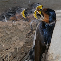
Despite there being a track running along the top of the bank near my camp, the only sounds are natural ones. Out on the river I saw two wedge tailed Eagles, both of which took off as soon as they saw me, their powerful wings driving them through the air. Generation long habits of shooting them because of the damage they inflict on young lambs has made them wary. Tree Martins and a welcome swallow chase insects in a showcase of acrobatic flying over the water.
A visual comparison between tree martins, fairy martins and welcome swallows.
Tree martin
Fairy martin
Welcome swallow
Tree Martin Birds in Backyards... The tree martin’s nest is a relatively flimsy structure made from dry grass, leaves and sometimes feathers (2) (3), although it will occasionally use some mud or even build a full mud nest (3). If a crevice is used, the tree martin may reduce the size of the entrance using mud pellets mixed with plant fibres. It has also been known to take over the nests of welcome swallows (Hirundo neoxena), building up the walls with mud and lining the nest with leaves. Tree martins may reuse the same nests over a number of years (2) (3). Arkive.orghttp://www.arkive.org/tree-martin/hirundo-nigricans/
A young female Grey kangaroo hops along the bank towards me, when she notices me, she stops and stares curiously. Eventually I am the one who moves on. A line of dusty fawn emus walk through the bush noiselessly and are gone.
The Murrumbidgee is quiet, narrow and snaggy.
About to head off. 8am. Looking a bit scruffy.
The grey Murrumbidgee mud, here pock marked by cattle hoof prints, is incredibly sticky. When it is the slightest bit moist it holds like glue. Walking over it after rain, it cakes under the bottom of your boots, or around your car tyres. The cattle had polluted this section of river bank with their droppings, making it difficult to find fresh water.
The Murrumbidgee really should be called eagle river. Few kilometres further I saw another 4, two close and two others soaring high in the sky. In the last three days I have seen at least ten white breasted sea eagles too. Paddled past Mungary Station at 10 o'clock. It is a modern lived in building. They are not so frequent around here and good to know that you could seek help there if need be.
Red bellied black snake crossing the river. They are good swimmers. I actually saw one with its whole body under the water except for the tip of its nose, until I had passed, then up it came and swum away.
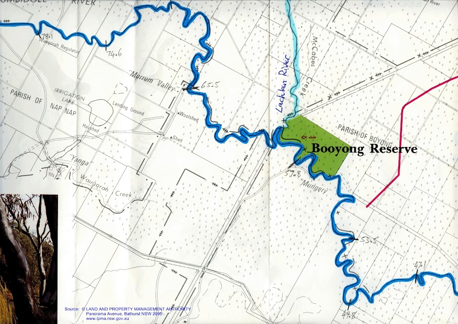
Where what remains of the Lachlan River (after it has sickered into the ground in 80km of swamp and floodplain landscape) enters the Murrumbidgee River.
Opposite the Lachlan, the Murrumbidgee goes round a sharp hairpin bend.
I was looking forward to a short paddle up the Lachlan. However a large tree lay across its entrance so it was not to be. The catchment of the Lachlan is comparable in size to that of the Murrumbidgee. The tiny stream that enters the Murrumbidgee gives no clue to that grandeur. One of Australia's first inland explorers, Oxley was frustrated by swamps when tracking the westward flowing Lachlan and Macquarie rivers. Charles Sturt, who heard of a great river to the South, located and travelled along the Murrumbidgee to determine whether it did the same (source). As Mike Bremers noted in his blog, it is a rather small river for one so long. Modest, except as with all the rivers around here, when they flood. Sturt followed the Murrumbidgee from Gundagai by land. It was not until just upstream of the Lachlan, that he launched the 9 metre whale boat his party had transported in pieces from Sydney. They also built another smaller boat, for their provisions. It hit a snag and sunk (along with most of their food supplies) on the second day.
Straw-necked ibis and freckled ducks in Booligal Wetlands, Lachlan Valley, during spring 2010. Freckled ducks are listed as vulnerable in NSW. Following an environmental water release, four pairs of these ducks nested and bred in dense lignum that also supported nesting of over 60,0000 pairs of straw-necked ibis. Photo: Paul Packard, OEH.
The Lachlan catchment has an area of 90,000 square kilometres, extending from the Great Dividing Range to the Great Cumbung Swamp on the Riverine plains. The Lachlan has three areas of particularly high environmental value: Booligal Wetlands, Great Cumbung Swamp, and the Lachlan Swamp (map). All are listed in the Directory of Important Wetlands in Australia.
Coming up to Murrum Valley Station. Some strong wind gust coming from the north making the trees roar and sending white capped waves down the river.
Murrum Valley Homestead
Nearing Redbank Weir, the water level approaches the tops of the banks. Regulators control the flow of water into and out of the forest.
The Murrumbidgee in the last ten kilometres is like paddling through the narrows but without the current. The river is right to the top of the bank, which means I will have no trouble getting out. The river banks, like the narrows, seem higher in places than the bush either side. Just before Picnic Point on the Murray are signs to stop the waves from wake setting boats from eroding these and flooding the forest. No need here it seems; even on a school holiday weekend there is not s soul to be seen.
Approaching Red Bank Weir with high water. In this shot you can see how I have rigged the solar panel on the back. Not knowing if I could rely on a recharge for my batteries, I worked out this set up with my son, Tim. It includes a 17Amp sealed battery with heaps of power for my laptop and all the other devices. I use a cupholder inverter and then the leads the equipment was supplied with.
The bush always looks at its best in the afternoon sun.Note the high water level, as the river approaches the weir.
On a south west reach of the river, not far from Redbank weir, I let the wind carry me: it's been in my face for most of the day, as the Lowbidgee winds north west. From Redbank onwards it strikes a southerly direction once again, onwards to the Murray.
Arriving at the weir I asked a man in a fishing shack where the best place to pull out would be. He suggested that I pass through the safety barrier, not straying too close to the weir as the gates were open, and then get out at the grassy area - which I did. It turned out that he is the caretaker and the head of a nest of red necks. Two of his sons came upstream in a tinny. One standing in the front with a shotgun, shooting at anything that moved. They waved at me, though for a second I thought they would teasingly point the gun my direction. They continued blasting as they travelled full speed (with their smallish motor revving its heart out) 'Apocalypse Now' style up the river. They came back later and continued blasting. God save the wildlife (and them: there was a sign saying 'Yanga National Park, no hunting'. Ok, I decided not to ask for a hand with my gear. Later, on land, I spoke to one of the older fellas. He built the shack. His friend was the caretaker, but he had moved into town. They come about ten times a year to hunt. Good news, no more crazy caretaker. Bad news, he has some crazy friends.
My GPS (it's working again now that I've put in alkaline batteries) shows that the total distance from Maude to Redbank Weir was 97 km which means that I paddled about 49 km today. With the slow current and headwinds that took me 7.5 hours, with an average speed of around 7 km/hr.
This stretch has definitely been a pretty paddle, with the wildlife, in particular, the wedge tailed Eagles, emus and kangaroos a highlight. Surprisingly, about 10km upstream of Maude are a series of new camping areas, each with picnic tables and toilet block. These weren't on the map, but as far as I am concerned, are a welcome development.
This shot is to show the regulators in use above Redbank Weir. This is one of the new ones. The bush looked pretty sad in places. It seems to be still recovering from the last drought. environmental watering (occasional flooding mimicking the natural cycles) is important to them looking healthy again.
Approaching redbank weir. Sunlight on reeds.
There were familiar sights too, a pelican who takes off with his head to one side, as if to say, 'Hey man, you might not realise it, but this taking off business takes s lot of effort. Why do you keep following me?' I have been following him for 60km. Finally today he let me pass him without taking off.
Downstream from Redbank Weir at 1,800 ML per day. Lee Baumgartener's 2005 study into the effects of Redbank Weir on fish migration found that the Redbank and Balranald weirs obstructed fish migrations during summer and autumn and many species of small-bodied fish such as Australian smelt, western carp gudgeon, fly-specked hardyhead and crimson-spotted rainbowfish accumulated downstream of Balranald Weir. In addition, downstream accumulations of juveniles of larger-bodied species such as bony herring, common carp and goldfish were also detected. A simple fishway was built at Balranald, but no ladder exists at Redbank, effectively halting native fish migration at this point in the Murrumbidgee.
Downstream from Redbank weir at low river (Flicker) at approx 700 ML per day. Redbank Weir was built to composite landholders for the lack of natural floods that occurred after Burrinjuck Dam was built in 1909. Redbank Weir was built in 1940, just after the outbreak of World War II, funds to finish the project were diverted to the war effort. leaving levees necessary to water the flood plains incomplete. On the 9th of December, 1944 the Sydney Morning Herald reported that 100,000 sheep died when the rich river flats instead of supporting lush grass growth, were grey and cracked, 'as dry as any desert'. Arguments between the states exacerbated the problem. The Murray Darling Basin Plan aims to balance the interests and rights of all states and interested parties, from the river's source to sea - an unenviable task.
Tasting the forbidden fruit.... ah! Such a treat to be able to lie down after 8 hours canoeing.
A last parting thought. I the Millenium Paddle Blog and Mike Bremer's Murrumbidgee Blog, they mention stony ground 'reefs bedded with stone', I have noticed this in my last campsite in the middle of the bush and all over the bank. At Redbank weir there are great clumps of the stuff, a real outcrop. The stone is a type of limestone that forms when calcium carbonate rich ground water repeatedly reaches the surface and retreats. I think it occurs were ancient seas left behind subsurface soils with a high shell content. So when you see those rocks, it is a greeting from the time when the inland sea reached as far as Kerang, and, dare I say, Redbank
.


 PhD Candidate researching Murray River floods.
13 years expat experience living in Germany. Worked in Australia, Africa, Antarctica and Germany. Enjoys the environment, my family, people, travel, cultures. Inclination towards adventure. In 2012 (low river), and 2016 (flood) completed a kayak journey of 2,400 km on the Murray River from its headwaters to the sea and continue to explore, document and share expeditions on the rivers of the The Murray Darling Basin. Uses these experiences to understand rivers, river ecosystems and the communities that depend on them and encourage people to discover and share what they value about their environment. Rivers bring life and connect people. Education should be like that too.
PhD Candidate researching Murray River floods.
13 years expat experience living in Germany. Worked in Australia, Africa, Antarctica and Germany. Enjoys the environment, my family, people, travel, cultures. Inclination towards adventure. In 2012 (low river), and 2016 (flood) completed a kayak journey of 2,400 km on the Murray River from its headwaters to the sea and continue to explore, document and share expeditions on the rivers of the The Murray Darling Basin. Uses these experiences to understand rivers, river ecosystems and the communities that depend on them and encourage people to discover and share what they value about their environment. Rivers bring life and connect people. Education should be like that too.