Dawn is breaking. There is now enough light to check the river height. A few noises from that direction, probably a cow going for its early morning drink, but potentially the sound of my boat moving around in the current, prompted me to suddenly jump up and make sure. The river has risen at least half a metre overnight. I am glad I took the trouble to drag my boat up high enough. The ground had been just firm enough to walk on. It was coated with a thin layer of silt, a tell-tale sign that the river had recently risen and then dropped quickly. I chose the campsite because the thinly coated beach reached all the way to the top of the bank, meaning that I could pull the boat up without too much hassle. I took as much of a run up as the river would allow and launched the boat far enough up the bank to step out onto the shore. Rose Fletcher got an awful shock once when the solid looking shore turned out to behave like quicksand. It can happen when rivers drop quickly. I was relieved when the ground held under my feet. The river's character does not seem to have changed. At least at my campsite it continues to slide quietly past. My gear is also still there. Cows can be curious beasts. Although they did a lot of sniffing in the night, it seems that they didn't do any tasting. My spray deck, life jacket and paddle are still whole.
 |
| After a wet night where things refused to dry, I donned my damp thermals and layered up and was soon warm once again. The beenie my brother Laurie had left in the car before moving back to China became my lucky charm; it certainly kept my head warm. The rain stopped just long enough for me to pack my boat in the dry. A piece of bread, an apple, a pack of diced fruit and a snap lock bag of muesli for brekky and I was off. |
The noise that awakened me with such a start, turned out not to be caused by cattle but the sound of air rushing out of
yabby holes on the opposite bank. There were hundreds of these and as the rising river filled them, they were behaving like little blow holes. Amazing.
On the water at 7:30, the rain has settled in again. I'm interested to see whether the river behaves any differently with a bit more water in it. It should actually be safer, as I can now paddle above the snags, rather than through them. I had some pretty hair-raising experiences yesterday. The Upper Murray is not by any means a safe river. Make sure your
skill levels are up to the challenge and you have the right kind of boat. A white water kayak or other kind of boat that can turn quickly, would be more suited than a sea kayak.
So far it's much easier than yesterday, the gravel races are a little more like Islands. 50cm of water makes all the difference; yesterday, they blocked the river and I was forced to paddle the races where the current ran. This meant negotiating
willows and finding ways through snags, with very little room for manoeuvring. With the gauge at
Bringenbrong Bridge reading 130 cm instead of yesterday's 80, I have a lot more choices.
 |
| My old friends, the pelicans. |
 |
River bank works put in place by the Snowy Mountains Hydroelectricity designed to limit erosion following the regular high flows associated with hydroelectricity generation.
|
The rain has cleared and the colours of the countryside are emerging as soft greens and yellows. This is in part due to the dominance of European trees, like the poplar and
willow, but also because of the effect the clouds have on the Autumn light.
The flat and broad valley I have been paddling through since yesterday has begun to run into hills - at times literally, causing an abrupt change of course in the river. At these points, the granite bedrock becomes exposed. Usually though, they flank the river, creating scenic backdrops reminiscent of classic paintings. The lushness and greenness takes some getting used to as a resident of the inland planes. I know the Murray as a brown, and at best, green stream which winds through grey green river red gums. Once a year, the shores are bursting with golden yellow, as the wattles flower. But I am not used to green. Here the grass is green, the shrubs are green and the trees (at least at the waters edge) don't look like they could ever grow fast enough. The cattle have a good life too, plenty of food, protection from predators and paddocks with a view that is hard to rival. Paddling past them, I sense that they think they have the better life, and perhaps they are right - just don't tell them what is at the end of it.
2.5km before Tintaldra Bridge, there is an island where you can go left or right. Whichever channel you choose, the island is precarious, as the current slams right into a thick band of
Willows. It is worth pulling up at the gravel race beforehand to have a look and then take your pick. Once you are at the island it is too late. I got through ok, but not without an expletive when I realised my predicament.
 |
| 2.5 km before Tintaldra there is an island with a very difficult sharp turn into it. I came through without mishap, but next time, will be pulling up on the gravel race and scouting beforehand. Once in the right channel, the passage is easy. |
Tintaldra
Tintaldra is a quiet town which had a promising beginning. Following earlier land claims by the Shelley family, the land was given out to selectors looking for land following the 1850's gold rushes. It suitability as a crossing point led to the establishment of a customs house and a store which served the entire region. This store with its redgum floor and yellow box beams is still standing today. At this stage Tintaldra was the only crossing on the Upper Murray. It had a doctor, a wheel right, a policeman, a post office and a blacksmith.
The freeing up of the land was achieved through the Duffy Land Act of 1862. The State Library of Victoria explains: '...in the 19th century land was a way of retaining and generating wealth. The problem in the early days of the colony was that most of the best farming land had been locked up by squatters in long leases at generous terms... From the Victoria’s earliest days a battle raged between the powerful squatters who wished to maintain their extensive land holdings and those who advocated for small-scale agriculture and housing... The Land Act 1862 (known as the Duffy Act) made 10 million acres (4 million hectares) of land- about 20% of the state- available to selectors. The government considered it a compromise between those who had been calling for years to release land for the poor man and the business interests of the wealthy squatters.'
As other crossings were built along the Murray and the surrounding towns developed their own services, Tintaldra's significance declined. It received a boost when f ollowing World War 1, 2000 acres of the Tintaldra run was purchased for soldier settlers, however, the town was burnt to the ground in the 1939 and 1952 bushfires. Sources: Wikipedia. Sydney Morning Herald article.
 |
| Tallangatta Information Centre |
 |
| Tallangatta Information Centre |
 |
| Tallangatta Information Centre |
|
 |
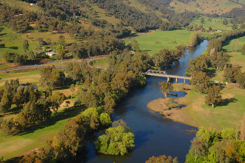
| Tintaldra Bridge |
Good photographs depend on the equipment working, as well as the subject being interesting. Lately I have been having some issues with water droplets on the lens, so last night I treated the lens on my GoPro and Olympus Tough with a product which is meant to cause water to bead and run off. However it was so humid in the tent with all my wet gear that moisture must have gotten into the GoPro, fogging most of the pictures. Luckily the small Olympus functioned well and you will be able to get a feeling for how beautiful the country is, when I have enough reception to share.
The light was stunning after Tintaldra Bridge. Whilst the valley was bathed in sunshine, the hill tops were covered in cloud. They give the landscape a tropical atmosphere. Sitting in my kayak, rugged up in thermals, waterproofs, life jacket and beanie, it doesn't feel tropical, but the sight of hills with their heads in the clouds reminded me of my times working in the Daintree.
Cudgewa Creek
Cudgewa creek junction: just upstream of marker 391: two kilometres downstream of Tintaldra.
At times it feels like I'm kayaking down a mountain stream with rapids and gravel races around every bend, at other times it feels like I'm back canoeing at Studley Park on the Yarra - the water is so still.
Currawongs are calling to each other either side of the river. In Echuca, the Currawongs are winter visitors, coming down from the mountains to feast on lilly pillies, their calls echo through the moist forests and gardens of the town. Perhaps these Currawongs never leave, or maybe these are the mountain birds, about to begin their journey.
First
darter sighted, perhaps this is a sign of the river is getting deeper. A mixture of basket willow, weeping willow, river red gums and plane trees line the river bank.
Fire tail finches (red browed fire tail) flit along the shore in the cover of the sandy banks. Pine mountain, a 1000 metre high granite monolith, larger than Uluru, forms an impressive back drop. All just downstream of the 380 km river marker.
 |
| Poplars. |
The river visibly banks around corners. It is forced up half a metre higher on the outside than on the inside of some bends. The water has momentum. When it hits an obstacle, like the outside of a sharp bend, it is forced up. On those same bends the speed of the river sucks the water away from the gravel races on the inside. The Upper Murray has its own shape, the water surface had its own contours.
|
|
Billabongs show where the river once ran.
|
 |
| Fertile river flats. |
On passing Big Hill Flat Creek, about 12km downstream of Tintaldra, the river leaves the broad valley I have become accustomed to, and, most unusually for a river, it enters the hills again. Whether it carved its way through these hills as they were uplifted, or whether they dammed the river and it broke through is a mystery to me. It continues closely flanked by hills till well after Jingellic and makes for spectacular scenery and many small rapids.
Three kilometres after Big Hill Flat Creek, the River Road hugs the Upper Murray on the NSW side. If you get to explore this stretch in a car, this is a great lookout. The bank on the NSW side is granite and rises straight out of the river in many places.
A little further downstream, I came across an
arboretum, a collection of trees from around the world. In the past, these were set up by forestry to see how well trees did in particular areas. It includes the most magnificent
Sequoia dendron (a Californian red wood, regarded by many as a living fossil, as they filled the forests of the world at the time of the dinosaurs. There were also
plane trees, a common feature of towns and cities in Australia today. For the next ten kilometres, plane trees covered the banks of the river; escapees.
 |
| Californian Red Wood. |
A kilometre after the giant redwood the river runs abruptly into the granite face of Mt. Welaregang and doubles back on itself, one of the few times that it flows in an Easterly direction. Marking the end of the mountain which blocked its path is a small, but quick shoot, which was fun to kayak through at this water level (130 cm at Bringenbrong Bridge). From here, countryside opens up once more and small idealic farms and lifestyle properties appear on the high ground, including 'Ponderosa Farm.' They must have the most magnificent views.
Pine Mountain.
As the valley opens up A spectacular waterfall (
Cudgewa Bluff falls) is running off the side of
Pine mountain facing the river. It seems to come from the clouds, as the top of the mountain is not visible. From this misty source, the waterfall plummets nearly 100 metres over bare granite until it disappears into the bush again. From there, it runs into
Cudgewa creek and then into the Murray. The air is so still that I can hear it tumbling down the slope, even though it is a good kilometre away. Pine mountain creek runs off the more Northerly slopes and is the next to enter the Murray. Both are just upstream of Ourie Creek.
 |
Pine Mountain is in Burrowa National Park. Pine Mountain - this gigantic rock monolith isreputedly one and a half times as big as Uluru. The exposed, lichen covered granite slopes dotted with soft, green Cypress- pine trees imparts a special appeal. A walking track leads all the way to the summit. Geological and topographic differences within the park have resulted in a range of vegetation types. Pine Mountain is of great botanical significance because of the number of rare and threatened plant species growing there. These include the Phantom Wattle (Acacia phasmoides), Fan Grevillea (Grevillea ramosissima), Pine Mountain Grevillea (Grevillea jephcottii) and Broad-leafed Hopbush (Dodonaea rhombifolia). Black Cypress- pines and Kurrajongs also grow on the dry, rocky slopes. Park notes. More information, particularly about access at Upper Murray Waterfalls.
|
|
Just after passing the 375 km marker, I reached Ourie Creek on the NSW side: one of the tributaries of more respectable size in this area of the Murray. The markers are yellow poles with numbers on them. They seem to be in kilometres and the distances they record might be the distance to Yarrawonga. They have been around for a while, as they are quite rusty, however, so far I have been unable to find an official explanation. Perhaps I am looking in the wrong places.
There is a set of small rapids complete with pressure waves about 5 km downstream from Ourie creek where the river takes a sharp left around a rocky pebbly reach.
 |
| Approaching Jingellic (from the NSW river road). |
 |
| As the river enters a narrow valley, rapids become more common. |
 |
Choosing a shallow path about 4km upstream of Walwa.
Fish use these to swim upstream... for this reason, they are also popular with pelicans.
|
In the last twenty kilometres of the day, hills flanked both sides of the river. It's course now seems to be dictated by the high ground on either side. What meanders and gravel banks there are are limited to the amount of room the hills allow them. For this reason there are many kilometre long straights and strange double backs around Jingellic. The rock that the river has cut through in forming this impressive bed is still visible as rapids and rock islands. The water backs up before these rapids and rock banks as long pools where there is little current, a stark contrast of what is to come at the end of them.
Walwa caravan park lies on one of these straights. Here the river is peaceful, a lovely spot to relax, fish, swim, or paddle. There is virtually no current, due to the inevitable rock wall at the end of the three kilometre long reach. Sandy creek enters the river, just downstream of the caravan park, and, true to its name, had pushed a small sandy spit into the slow moving Murray following the rains of the last few days. Walwa creek is at the end of the reach, but is far less obvious, as its entrance is hidden behind an island.
Jingellic.
The first thing you see of Jingellic are the pylons of the old bridge, which have been left as a sort of industrial sculpture, a reminder of former times. Immediately after the bridge, there is an opportunity to pull in to the Jingellic pub, famed to have one of the best beer gardens on the Murray. Camping is free on the reserve in front of the pub. There are free BBQs and access to showers. I can vouch for the quality of the meals. The rest of the town is further inland, on higher ground, safe from the Upper Murray's powerful floods.
 |
| Approaching Jingellic Bridge. |
 |
| Old Jingellic Bridge. |
 |
| Good meals and free camping at the Jingellic Hotel. |
 |
New Jingellic Bridge.
|
|
I read a story of a man who grew up at the butter factory at Walwa. He earnt money for comics by trapping rabbits and delivering them to the pub. |

Like Tintaldra, Jingellic is a picturesque small river town where it seems time stood still and development passed it by. However, their sleepy natures, beautiful settings and historical buildings have made them preferred destinations for travellers, motorcyclists and car rally clubs. Whilst most people head for Jingellic's famous pub (camping is free on the river banks in front of the hotel, hot showers are available and the meals are great) the rest of the town retains its quiet nature. The old school is now an arts and crafts building and the opening hours on the shop are more convienient to its owners than the public. The pub, which boosts one of the best beer gardens on the Murray, is just after the old bridge pylons. Inside the hotel, there are pictures and stories from the past. As in other river towns, the bridge is central to the town's identity and success. Before the first bridge was built, locals crossed the river at a ford at Horse Creek. Up until federation in 1901, Horse Creek ford was a popular smuggling point for locals avoiding the customs house set up on the Victorian side. In 1959 the new bridge was built downstream of town.
|
|
With the establishment of a butter factory in town, traffic increased making the old bridge unsafe. A new bridge was built downstream, causing a re-alignment of the road around town. Source |
|
|
 |
| Log jams show the height and power of the river in flood. |
I paddled around 70 km today, making it to Talmalmo cottage where Ruth was waiting. In doing so, I almost reached the front of the rising water. The water had only just begun to rise here. At the head of the surge water quality was decidedly less, as it picked up the fresh cattle droppings which pepper the river banks. Reaching the head of the surge near Jingellic, the river was white with tell tale floaties. Cattle have free access to the river for most of the Upper Murray and water quality suffers as a result. What should be the best water in the Murray is potentially the worst. Although there are cattle all along the Murray, for most of its journey to the sea it is buffered by natural environment. In the Lower Murray that natural environment is made up of the impressive sandstone cliffs, in the Murray downstream of Albury, it is forest. Both protect the river by limiting the number of access points available to cattle to reach the water and mean that there is less of the shore covered in cow pats. Catchment authorities and conservation groups are pushing for cattle access to be restricted. When I first heard of this I thought it a bit extreme, but when you can't drink the water in what is otherwise the cleanest part of the river, something is wrong. This water is so clear that you can watch the pebbles pass beneath you as you paddle, why is it not also the healthiest?
Talmalmo Cottage.
I am sitting on the balcony at Talmalmo Cottage, around twenty kilometres downstream from Jingellic. It is so peaceful. The cottage has a magnificent view over the valley.
Magpies are singing and the pelicans moving to their morning's fishing spots. Sunlight has touched the top of some of the hills, but not yet all. It has a golden quality to it, as though it is gently waking all that it touches. Most of the valley is still in shadow. Soon it will be its turn. Until then, the already impressively long morning chorus will continue. It is so peaceful here. I think I might break the journey and savour it a while longer.


 PhD Candidate researching Murray River floods.
13 years expat experience living in Germany. Worked in Australia, Africa, Antarctica and Germany. Enjoys the environment, my family, people, travel, cultures. Inclination towards adventure. In 2012 (low river), and 2016 (flood) completed a kayak journey of 2,400 km on the Murray River from its headwaters to the sea and continue to explore, document and share expeditions on the rivers of the The Murray Darling Basin. Uses these experiences to understand rivers, river ecosystems and the communities that depend on them and encourage people to discover and share what they value about their environment. Rivers bring life and connect people. Education should be like that too.
PhD Candidate researching Murray River floods.
13 years expat experience living in Germany. Worked in Australia, Africa, Antarctica and Germany. Enjoys the environment, my family, people, travel, cultures. Inclination towards adventure. In 2012 (low river), and 2016 (flood) completed a kayak journey of 2,400 km on the Murray River from its headwaters to the sea and continue to explore, document and share expeditions on the rivers of the The Murray Darling Basin. Uses these experiences to understand rivers, river ecosystems and the communities that depend on them and encourage people to discover and share what they value about their environment. Rivers bring life and connect people. Education should be like that too.