Showing posts with label river management. Show all posts

Lowbidgee Day 1 - Hay - Pevensey Station


Mike Bremers: Murrumbidgee Canoe Trip 1995-2008 


It's already pretty out on the river. There is a feeling of wilderness even on simply paddling around the bend and out of sight of Sandy Point (where I launched in Hay). The only sounds are birdcall and wind. It's a quiet river compared to the Murray - especially in a busy place like Echuca, where I am from. My boat is heavy with its newly laden with gear and food for 10 days, but it moves steadily through the water. The first few kilometres I find new spots for my gear, adjusting the load and positions so that everything can be used and doesn't get in the way. There is a current of between 1 and 2 km an hour; a steady drift but not easily visible as there are no tell tail ripples on snags. The river just quietly moves along. This may just be the character of the Lower 'Bidgee (lowbidgee). Time to put in some kilometres and get this trip started.

Bush camp

Tree roots exposed by the river


The sun is shining again now looking forward to putting on my hat. Ahead of me, three great cormorants are sunning themselves on the snag, look nervously this direction and are unlikely to stay long as I approach - being of the nervous kind.

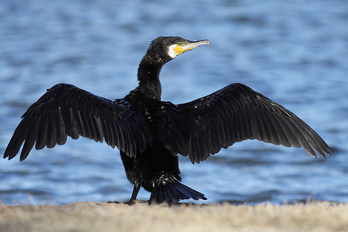
Great Cormorant: www.flickr.com
Museum of Victoria's Field Guide App for NSW help identify animals. It even has the calls of birds and frogs. Field Guide to NSW Fauna is a valuable tool for anyone with an interest in wildlife. Use it in urban, bush and coastal environments to learn more about the animals around you. 

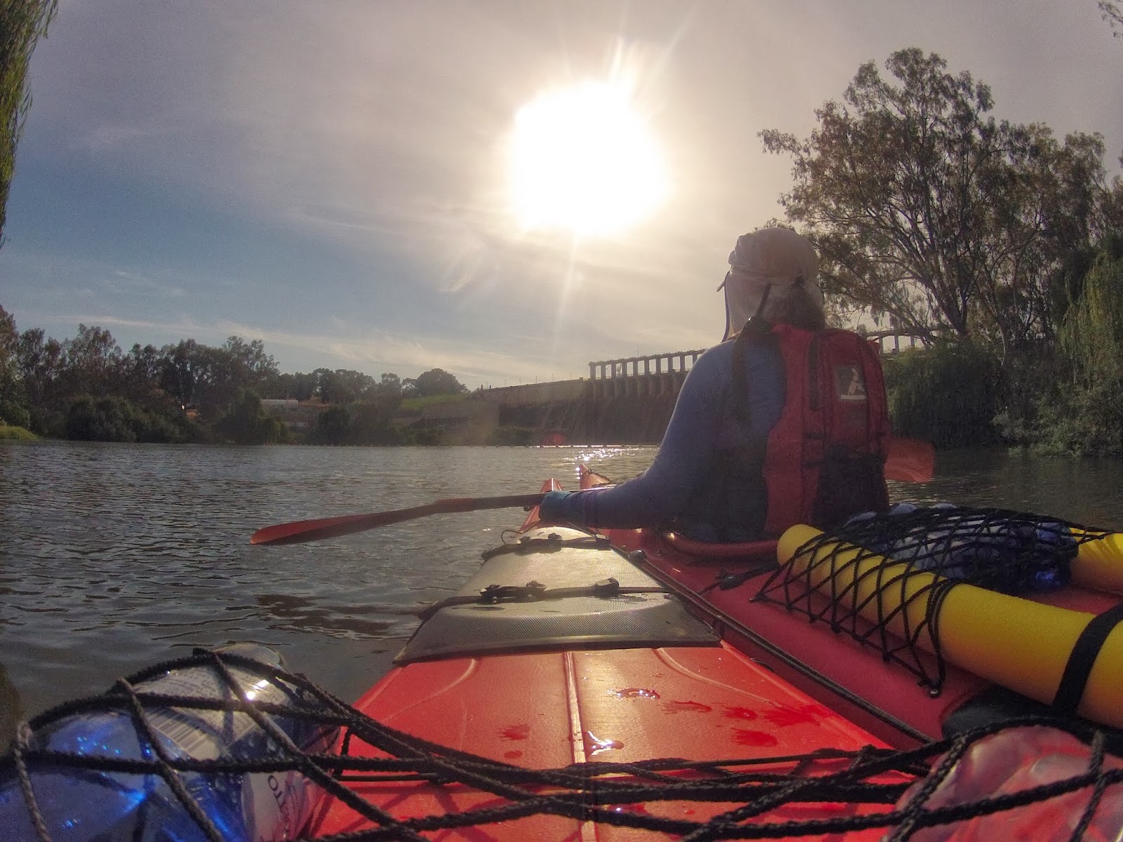
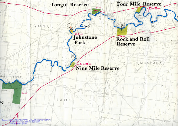
Now about 12 km into the paddle. The GPS is refusing to do anything but show it's start screen. Seems to have been an expensive mistake. Just have to wait a lunch break and try and see what I can do. I remember reading something about taking the batteries out and holding the on off button and then re-inserting the batteries and it should be right again. But I'd better wait until lunch when I have dry hands on moisture could get into the device. There is a fresh wind coming from the south-east so most of the time I'm heading into it. Following the map and the kilometres written into it, I am at about the 16 to 17km point - almost at Gordon Point at the 4 mile reserve.

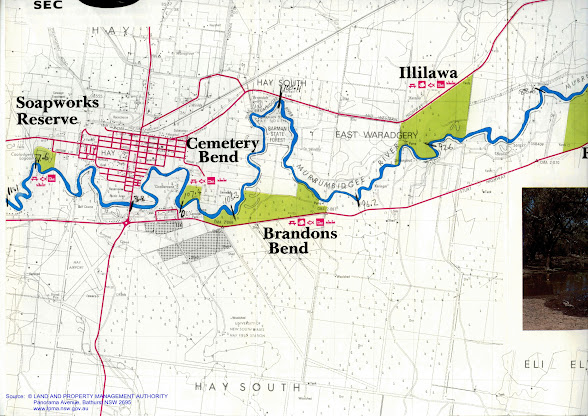
Near Four Mile Reserve I come across an old shearing shed in the Wooloondool State Forest. It seems to be in the process of progressively being swallowed up by the bush surrounded it. The shearing shed is located in a convoluted peninsula with the river forming a natural boundary for stock on all sides except for a narrow 'bridge'. Early settlers often used the land to their advantage like this. In Echuca, what is now the Scenic Drive, used to be a holding paddock for police horses and near Kulcurna Station on the lower Murray, a similar landform was used to trap wild horses.
“It’s like the old days of camping when you and the family take the dog, park the trailer, set up for a week, live on fish, and it costs you next to nothing.”
Wooloondool, part of Murrumbidgee Valley National Park, is within easy reach of the town of Hay, and it’s an ideal place to camp. Many set up camp at Wooloondool as it’s a great place for fishing - yellowbelly, redfin, brim, catfish, and carp, as well as crayfish during the season, can all be caught here." Wooloondool Reserve 


Just before Rock and Roll Reserve, about 18 km downstream from Hay, are the remains of a Fisherman's shack. Its roof is still intact, but the walls and floors have rotted away and only the frames of these and the front door is still present. I wonder if it was abandoned in the high rivers of 2010-11?

I have heard the beautiful calls of the Pied Butcher Bird through the forest. This bird is a bit of a conundrum. It looks like a stunted magpie, but instead of warbling and 'carolling', it whistles. Its song reflects off the gum leaves in the canopy and carries well over long distances. Despite its song and good looks, it did not get the name 'butcher bird' by chance, it has a habit of spearing its prey on thorns until it is ready to eat them. It hangs its meat to keep it fresh. The river this morning has also been home to pelicans wheeling into the sky on my approach, great cormorants, pied cormorants usually high in the dead trees that line each bank, australasian darters struggling to fly with crops full from the last dive, tree martins, brown treecreepers and pacific black ducks in their hundreds.

Android App: The Lower Murrumbidgee floodplain is a unique area. Use this app to learn about the Lower Murrumbidgee Floodplain and explore both natural and cultural wonders of the area. Investigate the diverse plants and animals of the Lowbidgee with over 100 species profiles presented and the ability to report a species you have seen. The app also includes information on things to do, places to visit, towns, national park information and a map. Visit the app's gallery to take the opportunity to share your Lowbidgee photos.
Approaching the weir the river nears the top of its banks.

Magnificent hollow in an old river red gum.

Trees flooded by Hay Weir provide habitat for water birds.

The hairpin bend just after Four mile reserve is a whistling kite nest in stately river red gum, taller than the rest of the trees, its crown reaching above the forest canopy. As I paddle past the tree, one of the kite gives its warning call, whilst the other circles overhead. The nest is small by eagles standards. I've recently learned that each generation adds to the nest and thus it becomes progressively larger with age. A nest near Bendigo has been documented to be over 400 years old. Later in the day I came across a much larger nest; it was about 1.5m tall and about the same wide.

White breasted sea eagle: Wikipedia
On the last hairpin bend before Hay Weir, a pair of white breasted sea eagles took to the air just above me. What a surprise! I watched their aerobatics for a minute or so, before they disappeared, one further down the river and the other to an impressive nest in a back water. I tried to take some photos, but the specks in my viewfinder turned out to be really specks and not much use to anyone. Despite being lovely pictures of clouds and a blue sky, I wont be uploading them to Facebook.


Watermarks showing normal water level

Spoonbill

White breasted sea eagle

Hay Weir was much bigger than I anticipated. I could see it through the trees as i approached. A tall rectangular structure, about the height of a four story building, it loomed ominously as I rounded the bend. The weir completely blocks the river and with no way of going through it (there are no locks on the Murrumbidgee) you have to get out. With the weir pool dropped by about a metre, I had to really struggle to get my boat up the bank - especially since being the first day, it was heavily loaded. Mike Bremers and the Great Millenium Trip blog talk of picnic areas, toilets and lawns kept green by sprinklers, however I was unable to find no more than a derive BBQ and some orderly piled rubbish from campers. It seems that it is not the place it used to be. To relaunch your boat, you need to follow the river for a couple of hundred meters until you are past the fenced off and rock protected bank. There, a fisherman's track heads down to the river. It's a different river below the weir; the banks are high once more and the current surprisingly swift.


Hay Weir appears like a gateway in the distance.

On the other side ther are no more dead trees

And the banks are natural once again.

A pair of black winged stilts lure me away from their nest by flying ahead. All black and white except for long red legs. They look more like a seabird then something you would find in inland Australia. Once I am far enough away, they simply turn and fly back at head height right past me - obviously they are not used to being hunted (thank goodness).

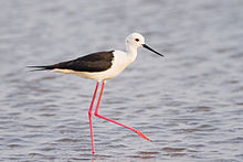
Black Winged Stilt: Wikipedia
The river downstream from the weir is much more natural. The dead trees that have been my companions since Hay are gone and the river is less grey. the green of its water are complemented by living vegetation that at times comes right down to the water's edge.

There was a lot of water coming out of the weir. The flow at least in the first section is as good as the Murray. The wildlife seems less disturbed, though remains timid.

As the afternoon rolls on the sun comes out more, creating sparkles on the water's surface. It is a pleasure to paddle this section of the 'bidgee.


My first beach since leaving Hay.

The Lowbidgee winds through farm...

And forest...

About 20 km below the weir I came across Pevensey Station, I felt nostalgic for the grand old steamer that is the pride of the fleet at Echuca. PS Pevensey was named after this wool station (wikipedia). She was known as the PS Philadelphia in 'All the Rivers Run' - a mini series from the 1980's which depicted the river trade. I stopped and tried to imagine what it would have been like in those days. I tried to take a photograph, but with the advantages of being close to the water in a kayak there have to be sone disadvantages - having a difficult time photographing things that are on top of the bank is one of them. I settled for a row of old fuel tanks (a snapshot of rural life) when it was the station I was actually interested in.

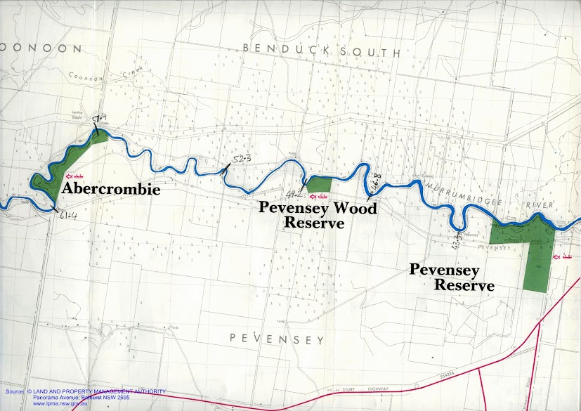
PS Pevensey... named after a wool station on the Murrumbidgee River.

Steamers were a connection with the outside world. Not only were they good for business, but they also brought visitors. Some were churches, like the PS Etona, and performed weddings and baptisms along the rivers. Others were shops, selling pots and pans and flour. Still others were fishing boats, like the PS Canberra and kept their fish fresh is netted half sunken barges towed next to the steamers. The PS Pevensey was one of the grandest of the wool boats. Wool bales were stacked until the captain could only just see the river and even higher in the huge barges behind them. They allowed this area and the people who lived in them to prosper and establish the great properties that still exist today. Rail brought the end of the river trade, just as road transport led to the closing of most branch lines almost a century later. Now the Murrumbidgee is full of snags and the weirs placed on this river do not allow the passage of boats as they do in the Murray. More is the pity.


Boats loaded with wool bales at the Echuca Wharf.


On this section...

There is..

A sense of isolation...

Ther is just you and the river...


Pevensey Station: fuel drums.

Pevensey Station


Not far after Pevensey, I found a large beach with enough room to pitch my tent out of reach of dangerous branches. I turned around, took aim and paddled hard so the the first half of the kayak would launch onto dry land. I then pulled up my boat, out of reach of a possibly rising river (following yesterday's rain and the amount of water that was being allowed through the weir.


My campsite near Eulalie Station, just downstream from Pevensey Station.


Wahlenbergia stricta: native bluebell. A plant which has survived from Gondwana times, it exists in South America, Australia, South Africa and New Zealand.


After setting up the tent, I settled into cooking, determined to eat my way through my boats food stores. I am sure I have brought too much. I usually do. Sitting watching the sun go down, whilst dinner cooked was very peaceful. It is the time of day when birds seem to wake up again,with either the urge to be social, or to eat - it is difficult to tell which is the case, they seem to be doing both.

Murray Rosella: the yellow form of the crimson rosella.
Spotted doves were feeding on the grass seeds on the beach, yellow plumed honey-eaters squabbled, Murray Rosellas found young buds on the red gums, biting them off to get to the sweet sap that feeds them. There must be a grey shrike thrush. These are a beautiful to listen to. Their song is almost as varied and inventive as a lyre birds'. Two strong looking young bulls came down too. Luckily they were not too curious. Better pack up well tonight though. Tomorrow I hope to reach Maude.


The spotted dove is native to India. It was introduced to Melbourne in the 1860's and quickly spread, sometimes replacing native doves (wikipedia) .Spotted Doves feed on grains, seeds and scraps. The birds are seen alone or in small flocks, feeding mostly on the ground (birds in backyards).

Why the Hume Dam?

Despite growing up on the river, I am always surprised how much I did not know. In addition, I enjoy learning of the stories of people who had gone before, as well as those who continue to work on these projects, but go unnoticed and unheralded.

Beginning our trip at this work of engineering which has such a big effect on our lives, it only felt right to honour the foresight, courage and continuing expertise and planning which enables so many hundred of thousands of people to live in the interior of our dry land of drought and flooding rains. There is a lot more information than I have included here; I have included links to websites with more information and to the sources of photos which are not my own. Each has its own story.

Because of dry years from 1904, severe El NiƱo events in 1914 and 1915, and the pumping of water for irrigation, in 1915 the River Murray dried up completely. Families took the opportunity to picnic in the river bed at Koondrook. Culture Victoria

Raft in Fiery Creek, Mininera East, Victoria, 1935
Museum of Victoria

It did not take the early settlers who arrived a few years after Hume in 1824 long to realise that water flow in the Murray was highly seasonal and that 10 times more rain fell in wet years than in dry years. They also dreamt of that if they could spread the massive winter flows over the year then the Murray could be used as a transport system. Hopes were to rival the great European rivers like the Rhine and the Danube, and Mississippi and Great Lakes of North America. By the time that it was built the river trade was already dying, rail had reached the inland towns and stations and could be used all year round. It did, however fulfil its secondary goal, further than any expectations. The Hume allowed a steady flow of water throughout the year. The raised river levels from the weirs that had been constructed for the river trade allowed irrigation channels to bring use gravity to convert large areas of grazing country into productive farmland. It provided drinking water security for river towns and cities, like Adelaide and allowed them and Australia's population to grow. It truly was an act of nation building. More than any other piece of infrastructure, we can thank the Hume Dam that so many people live and profit from the Murray Darling Basin today.


As we start our journey beneath its ageing edifice I will honour those people who created it and those who strive to use it wisely for the benefit of others.


The Hume Dam was constructed between 1918 and 1936 (and was at the time the biggest dam in the Southern Hemisphere and one of the largest in the world). Horses, steam engines and manual labour, including hand to hand passing of rocks was used to create the wall.


http://www.bordermail.com.au/story/56571/75-years-on-no-plaque-for-hume-dam-deaths/

To improve efficiency, a flying fox capable of carrying 10 tonnes of rocks was built on the NSW side. Clay was loaded onto small trains and transported to where it was needed on the supporting banks on both sides of the concrete core. From there it was taken and distributed by 130 horse drawn scoops and compacted by their hooves and wheels in the process. Construction peaked in 1926 with 1000 men working on the project. Workers lived in their own little village, single men in barracks and married men in cottages. The village had its own church, school and stores.

http://www.abc.net.au/local/photos/2013/04/12/3735488.htm

When the project was finished in 1936, it was the biggest dam in the Southern Hemisphere and one of the largest in the world. It was hailed alongside Sydney Harbour Bridge as one of the mightiest Australian structures of the inter-war years and was one of the first great inter-government co-operative projects facilitated by Federation.


http://en.wikipedia.org/wiki/Mitta_Mitta_River

The site was originally called ‘The Mitta Mitta Dam Site', but in February 1920 the River Murray Commission chose the name ‘Hume Reservoir' to honour Hamilton Hume.


Hamilton Hume (19 June 1797 – 19 April 1873)

The main use for Hume Dam is to supply water for irrigated agriculture. This is critically important to downstream communities and the wider economy. However Hume Dam also provides water that is ultimately used for urban drinking water (including Adelaide), as well as stock and domestic use, river flows, industry, flood mitigation and increasingly for environmental flows in the Murray River. 


Murray Darling Basin Authority: 


Hume Dam follows an annual cycle of filling and drawdown (where water is released to the River Murray). Water comes into the Dam during winter and spring each year. Water is released between December and May, usually to less than half its capacity by the end of autumn. 


During the filling phase minimum releases are maintained for as long as possible. The minimum release from Lake Hume is 600 megalitres per day (ML per day). This is increased if needed to ensure that a minimum flow of 1,200 ML per day is maintained at Doctor’s Point to provide sufficient water for the environment. Doctor’s Point is immediately downstream of the junction with the Kiewa River, a few kilometres below Hume Dam. Typically the filling phase runs from the end of the rural irrigation season in mid-May to some time in the late winter or spring, depending on seasonal conditions and irrigation demand.

During peak farming season, water demand in South Australia and the irrigation areas along the Murray River can exceed 30,000 ML per day. This is more than the flow that can pass along the river channel without causing flooding. To avoid the need to supply such high flows, efforts are made to get the required water down to mid-river storages such as Lake Victoria earlier in the season. The river channel between Hume and Yarrawonga has a capacity to pass 25,000 ML per day without flooding.


Further downstream at the Barmah Choke, at the western end of the Barmah-Millewa Forest, the maximum flow is about 8,500 ML per day. Flows greater than 8,500 ML per day cause flooding in the forest, which is undesirable in certain seasons of the year. When it is necessary to transfer water downstream at rates greater than can pass through the Barmah Choke, alternative routes through the Mulwala Canal and the Edward River may be used to pass additional flows. Such transfers are usually required when Darling River resources and downstream tributary flows are low.

River Murray System Poster

Water released from Lake Hume takes about a month to reach the Murray Mouth, so releases must be made up.http://www.lakehume.org.au/management.aspx This estimate is made assuming a 3km an hour average flow in the Murray, so sometimes it might take a lot longer and sometimes somewhat less. I think the figure is optimistic.

Current release from the Hume is 20,800ML per day, an increase of 3,000 over 3 days ago.http://waterinfo.nsw.gov.au/drr/murray.shtml this website is very interesting as it gives an up to date picture of how water is flowing down the Murray Valley and how its tributaries and canals are being used to get water where it is needed in peak times. I was unaware of the effect of the Barmah Choke on limiting the amount of water that could be passed down the river to SA and how important the Edwards and Yarrawonga Mulwala channels are to fulfilling the needs of users all along the river.


Murray River Paddle