Murray River Paddle 2016 Day 44 Katarapko Creek (Pyap) - Moorook South

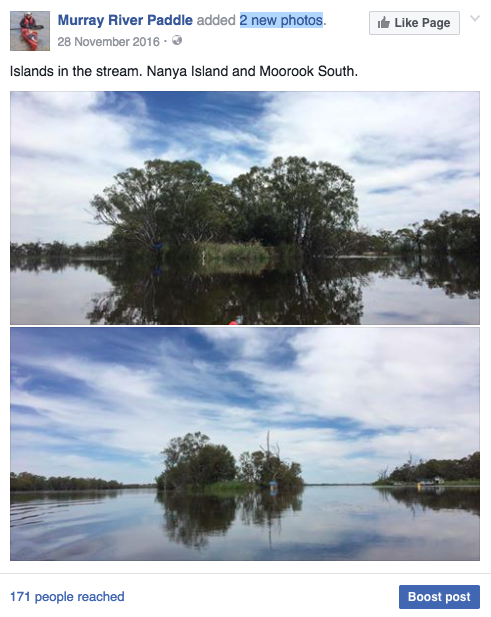
Day 44: 452 km Moorook South 28th Nov 2016

Katarapko - Seven Mile straight - River Islands - Orchards - Vineyards - River stories


Pyap to Moorook South.

I was delayed in leaving my camp on Katarapko Creek (just downstream from Loxton) because I had arranged a radio interview with ABC Riverland at 9:20. When you wake at 5:30 and get up soon afterwards this seems like forever. I t did mean that I could enjoy a leisurely breakfast and was able to use up the last of my butter, which had to my surprise, lasted 4 days without refrigeration. I had kept it low in the hold and had a wet towel on top, but given the strength of the sun, I didn't expect it to last. I consciously enjoyed toasting my bread roll on my spirit burner and layering the jam on. Pure luxury, chased down by a cup of tea.

Packed and with still an hour to go, I took a walk through the sand dunes along the track that connects the designated campsites. One of them was on a midden. You could tell from the thick layer of mussel shell fragments. Middens were everywhere here, it must have been a rich environment for the original inhabitants.

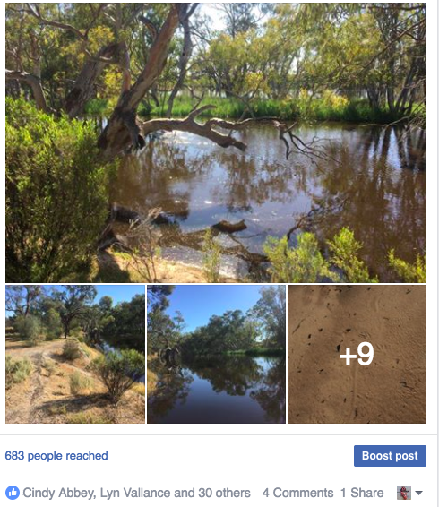
I had underestimated the size of Katarapko Creek. Creek indeed. Whilst it looked as luscious as the narrows (where the river flows through the Barmah Forest), it was twice as wide as the Murray at Echuca. Everything is bigger down here.

The track that ran between the campsites had been cut off for sometime, as there was no evidence of tyre tracks. However it was covered in animal tracks. As expected, kangaroo prints showed up as they hopped across the road, but there were also tracks from small marsupials, goannas, snakes and small lizards.

I enjoyed myself that much that I had to rush back to camp to be on time for my radio interview. These interviews are important to me as not only do they share my concern about the river, but they also are preparation for the second part of my study. This trip, and in particular the photographs I am taking, set up a baseline against which to compare people's memories, experiences and photographs of what the river used to be like. The radio is a way of reaching a wide audience and the more people from all walks of life I can reach, the better.

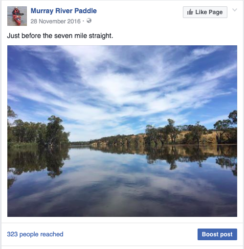
Keen to get going, I set off and maintained a good pace until I reached my campsite for the night at Moorook South. This included the 'Seven Mile Straight', this time thankfully without headwind. This whole area is fairly densely settled, however on the Seven Mile Straight the countryside is fairly low. Billabongs and lagoons, filled because of our proximity to Lock 3 mean that all development is up on the hills and away from the river. The names of the old stations are preserved as landing names, Pyap Hut Landing, Zeppels Landing, Klaus Landing, Shiers Landing and amusingly New Residence Landing (must have been particularly posh).

Where the banks were close, I could see orange farms and vineyards. The trees on the banks below most were in good condition, but below some, they were all dead. These changes stopped at their property boundaries. What was going on there: salinity, poisons, fertilizer, ringbarking?

Moorook South has a lovely grassed camping area and the shop is well known by paddlers who have appreciated its wares after a battle down the straight, be it hot chips and coffee, or iced chocolate and ice-cream (depending on the weather). I met two friendly couples, who had travelled from Adelaide to spend a few days on the river. They invited me to share a BBQ with them and told me stories from their community at the end of the river. Without everybody’s stories, we don't get the whole picture.

Tomorrow, I will push off early. I aim to make it to the Overland Corner Hotel for lunch and a cold beer (finally). The day will take me past Lock 3, more wetlands and canoe trails, Banrock Station and more Paddlesteamers landings. History is written all over this landscape. I am enjoying attempting to read it.

Murray River Paddle 2016 Day 43 Booky Cliffs - Katarapko Creek

Day 43: 482 km Katarapko Ck, near Pyap 27th Nov 2016

Bookpurnong - Riparian zone - Layers in the cliffs - Salt evaporation basin - In search of a cold beer


Booky Cliffs to Pyap.

My campsite last night was on a tight corner beach opposite Bookpurnong cliffs. The upper parts of the beach, which are now flooded, have beds of reeds. Behind them, in the shallow water, are flowering groundcovers and emergent rushes which cover the ground in a mosaic-like jigsaw pattern, broken up by areas of bare sand. These shallow waters are teeming with baby fish and all sorts of water life. The reeds protect them from the current, provide shelter from predators like larger fish and birds and are also a food source. These beds, or their equivalent are missing along much of the river. In fast flowing areas where reeds have trouble establishing, snags can be used to slow the current down on the river's edge. River Myall, or Swap Willow as it is sometimes known, provides a similar habitat when the water rises, as do willows, though these are not popular on much of the river because of the way they narrow the channel.

In Renmark, I watched how willows, reeds and rushes dampened waves from passing wake boats. Barely a ripple reached the, at times, fragile riverbank edge. With the demands we put on our rivers for irrigation, water supply and recreation we need to look after its banks. Looking after the banks reduces erosion, it reduces loss of land to farmers and householders whose properties border the river, it improves the quality of the water by filtering sediment carried by the river and by reducing the amount of soil entering the river, and, it provides habitat for the animals and plants which use the river as a corridor to travel from one place to another and is part of the natural picture which makes the Murray River such an iconic Australian landscape.

At Kaiser's Landing about halfway between Berri and Loxton, are the most beautiful cliffs. Like others in the area, its soft crumbling face tells a story of past climates. There are layers of pebbles, sand, and clay stone, each representing a different period of time. The larger the size of the stone, the stronger the current and the wetter the climate was at the time. In the middle of the rock face is a thick series of horizontal layers. These must be harder than the rest because they jut out further. In the shelter they create fairy martins like to nest. They build their nests from mouthfuls of mud and saliva, much like swallows do, except theirs have narrow turtle neck like openings. In the vertical faces beneath them, rainbow bee-eaters are nesting. They burrow into soft sediments, a round hole the only clue that they have been there. Drifting past, the cliff is alive with the calls of small birds.

The contrast to the other side of the river couldn't be greater. Where tall gums with diverse understories stood further up river, are dead trees and seemingly empty space. Little vegetation taller than a salt bush seems to be growing. This lower part of Katarapko Island has been used by the Loxton irrigation scheme as a salt evaporation basin since the 1960's. This has resulted in all but the most salt tolerant species disappearing from this part of the National Park. When the river has high enough flow that the salt will not negatively affect downstream communities, it is used to flush the salt out of the wetlands. This must be such a time and I wonder how the wetland will react. From the dead trunks, I can tell a little of what it looked like before. However, things may not be as bad as they seem. Apparently the salt marsh is an important water bird breeding area, flushing the salt to the sea in times of high flow mimics natural processes and the salinity is not as difficult to rectify as on the land.

I planned to camp tonight at Loxton Caravan Park and have a wander through town to get a feel for the place and learn a little more about its history, but the caravan park was underwater, except for a new area, which would have been a long drag of the boat and had no shade whatsoever. No fun when you are in a tent. I pushed on.

On the next bend I came across a teenager and his younger sister. They had pulled into the bank at a campsite and were collecting rubbish. In a few minutes they had two bags full and put these in their tinny. Complimenting them, they told me that they lived just up the hill and just felt like tidying up because you shouldn't leave the bush like that. What great kids!

Katarapko Creek re-enters the Murray opposite the site of the town of Pyap. Like Lyrup, Pyap was one of the communes to be established in the depression of the 1890's. Unlike Lyrup, it did not last. They had problems with the pumps, many people had an issue with working communally and the management seemed to make decisions on whims rather than after considering submissions. The town was abandoned in 1903. With no cold beer to be found in Pyap, I headed up Katarapko Creek about a kilometer, finding a lovely cool spot amongst young gums and so far is still mossie free! There are Corellas, Murray Rosellas and Grass Parrots in the trees, Crested Pigeons down by the water's edge and Honey-Eaters in the tree crowns. The presence of Magpies and Ravens shows that agricultural land is not far away. The sandy soil is covered with the same flowering ground cover as at my last site, together with pig face, saltbush and a whole swag of dry land plants. A family of Kookaburras has moved into the old gum near my camp and are beginning their chorus. They keep interrupting however as one of the young ones can do little more than squeak. Sounds like it has a very sore throat, more like a frog than a kookaburra. I guess it takes them time to develop their singing ability. Behind my camp, on the high ground, red kangaroos are feeding. I can hear Butcherbird's whistles being relayed through the forest. Taking the road that leads up there I can see lizard tracks. A Bronze Wing ground pigeon breaks cover for the safety of a distant tree, and everywhere are sugar ants with surprisingly large mounds of sand around their nests. They'll have to move camp soon. The river is rising. After a bit of a break, the evening chorus had begun. This time the frogs have joined. Like the young kookaburra, I'm not sure it's an improvement.

Tomorrow I have time to do a little exploring of the creek, before pushing on towards Moorook.

Murray River Paddle 2016 Day 42 Renmark - Booky Cliffs

 Day 42: 520 km Booky Cliffs 26th Nov 2016

Pike River Anabranch - Lake Alexandrina - Weir pools - Weekend visitors - Social experiments - Wilabalangaloo


I left Renmark around 9 am. A timely departure, seeing as my caravan park neighbours had just pushed off from the bank without their starter keys, and I was able to run these over to them. They told me that they had come from Goolwa, and that by the end of the millennium drought, there was so little water in the Murray Channel that a temporary wall was built from soil to make it navigable and to keep the salt from Flooding into the river. It was a contentious topic, with both long and short term residents split on what would be best. Many wanted the sea to be allowed into the lake as it naturally used to. Others thought this would kill off already weakened species. When the drought broke in 2012, it was removed.

Around the corner is the Renmark-Paringa suspension bridge. The road hangs from the framework above it. The lifting span is opened twice daily at set times. If craft want to go through at other times, they need to give two hours notice. A houseboat was approaching the bridge at full speed and continued to do so until approached by a tinny, who must have warned the occupants that they would not fit, because their turn was even faster. I thought I was going to see the span lift, as it was almost lifting time, however, no such luck. What did go under the bridge was a large clump of cumbungi, roots, leaves and all. I had heard that there were rafts of water plants floating, but this was the first one I had actually seen.

All the way along today’s stretch were campsites set aside for canoes and facilities for campers in general. It is certainly something that South Australia does better than both Victoria and NSW. Some of these were underwater, but the toilet blocks (thankfully) were always set up high. My camp tonight is one of those sites set aside for fishermen and canoe tourers. Set amongst bottlebrush and black box there are enough sites to cater for around 100 people. From my camp I was able to watch the last rays of the setting sun light the cliffs in front of me. There is no-one else here - perhaps the roads are cut off - just me and a family of red kangaroos. The camp is on a peninsula, with water and cliffs on three sides. Frogs are calling from amongst the reeds and the cicadas contribute to a low buzz in the air. At this end of the Murray one weir pool merges into the next, creating a flooded landscape. Old river channels carry water once again and billabongs are permanently filled. For canoeists it means that they can criss cross through the bush in a web of canals, getting up close to bird life and other wildlife. With the high water, some of those canals have got quite a bit of current flowing through them, which might be why I haven't seen too many people out and about.

Some of the canals are as wide as the river itself. Pike River (which runs along the base of the high ground within which the River Murray meanders), is really an anabranch. There are signs at both ends pointing to the real river. On the higher banks, campers in caravans and old buses were a common sight. It is the weekend and Murray is no longer so far from Adelaide. A dad in one boat had 6 kids with him, having the time of their lives.


I pulled over to Lyrup for lunch and a stretch and read a bit about the town history from an information board. Lyrup was one of those communities which was founded in the depression of the 1890's when there was very little work in the cities. Many were communes, social experiments. Most did not survive the test of time, but Lyrup is one of the exceptions. They recognised earlier than other communities that a single manager was more effective at making decisions than a committee, they had more clay in their soil, which was better for farming, and they allowed outside work and money to be used instead of coupons. The information board not only lists the names of the original settlers, but also everyone who left and why. Some left because they were dissatisfied, some married and some were expelled. The names of those who stayed have become street names; there is Bollenhagen Place, Tschirpig Lane and Olson Road. Today the irrigation is still managed cooperatively and the town is proud of its history. Lyrup is an example of how irrigation existed along much of the Murray long before its system of locks and weirs were built. It is proposed in some quarters that the drought of 1912 alone was not enough to run the river dry. Pumps along the river took what was left. These events were important drivers towards national agreements, and eventually federation.

A little further down the river is a station with just as impressive a name. ‘Wilabalangaloo’. It is registered with the National Trust. You can visit the property and walk around several kilometres of tracks along the cliff top and through the gullies that divide them. Seeking an opportunity to observe the river from a high vantage point, I found a place with enough of a sandy base for me to pull in and followed a track to the top of the cliffs. To get a little more height, someone had placed a wrought iron spiral staircase at the highest point: a stairway to heaven. Although I would really rather have stayed on the ground I edged my way up the stairs, testing each step to be sure it was solid. I did not want to test the rails too much,as they might not have passed that test and I was glad for what was still there. Seeing the Lower Murray from above highlights how different it is from the Middle and Upper Murray. The river is much wider, the bends are longer, (most are two to six kilometres long) and when the wind blows along those straight sections, or big bends, there is nothing to stop it.

It was nice to see people enjoying the river. The last 1700 km have been pretty quiet.

Murray River Paddle 2016 Day 40 & 41 Headings Cliffs to Renmark Nov 25

Headings Cliffs to Renmark: 565 km

Blackwater - Flood frequency - Water quality - Floating logs - Renmark - Classic cars


For the last part of the day paddling from Custom’s House (South Australian Border) to Headings Cliffs and for the whole of today we did not see one dead fish. We also observed that even at the time we left our campsite, that there were no shrimp gathered at the side of the river. This means that the black water and the fish it has killed upstream have not yet reached Renmark. It is possible that the blackwater in the river has been diluted by flows from tributaries, like the Chowilla Creek and Rufus River (Lake Victoria) and that the worst of its effects will be avoided because of it. Time will tell. However, there is no avoiding the fish deaths. There are reports that bream have been seen dead around Mildura. There are many backwaters and places where the river flows over the land, rather than simply down the channel upstream of Mildura which will have caused locally intense blackwater, so the fish deaths are not surprising. That the bream are also dying is not a good sign, they are hardier than the cod. Today, the river had not yet exceeded its banks around Renmark, however with a 30cm rise still coming from Mildura, this should be expected in the coming week or two. The question is really, how far will the effect be transported downstream? It seems that no-one really knows.

Tragic as it is, the fish seem to survive, or recolonise areas lost to their species following these events. Their numbers bounced back from the 2011 events. They should following this one too. Here, the habit diversity of the river is the key. Each stream, each cutting and each snag, offers survival niches. Were the Murray simply a channel, the whole population could be lost by such an event.

We arrived early in Renmark today and did a car shuffle from Mildura, preparing for Anna’s departure tomorrow. Since there is no public transport between Renmark and Mildura anymore, I hired a car. The car was driven to the caravan park where I am staying by a fellow who is a few years older than me. He is 58 and has been in Renmark all his life. “You know”, he said, “we never used to have black water when I was younger, so what has changed?” I agreed. In my 52 years at Echuca, black water - at least on this scale, has only been a recent phenomenon. Like most locals, he could name the years that the river had flooded in his lifetime. “We had floods in 74, 75, and in the 80’s, then 92, 2011, and now, but it is only the last two floods that have created this issue. They are no higher than those earlier floods and they were around the same time of the year. The difference is flood frequency, the number of times that the river has been high enough to flow through the forest has been decreasing. Before Dartmouth Dam was built the Murray’s level changed dramatically every year, watering its banks and rebuilding its beaches. It also seemed to flood about every 5 years. when Dartmouth was built, it doubled the holding capacity of dams in the upper Murray, where 95% of the rain in the Murray Darling Catchment falls. Water which normally flooded the forests and washed away the litter was caught and kept for irrigation. Now these high rivers seem to happen only every ten. In some places, much less. Large areas of the Edwards-Wakool Forest had not flooded since 1992 (24 years ago). Because the backwater is produced locally, it is possible that some sections of the river have been skipped. That dead fish have been reported at Goolwa, but nothing in between, suggests that blackwater has formed ahead of the main flow and highlights the complexity and patchiness of these events.

Booking into our caravan park, the ladies at reception told me that the blackwater had scared away many of their customers. “People think that we are underwater,” they said; “we’ve had lots of cancellations.” There is a lot of fear around the high river. The black water is not poisonous. It is simply dark in colour and low in oxygen. If the river was low enough to expose the beaches, I would be swimming in it - mind you, not if there were a lot of dead fish around. Though dark, the water is actually clearer than usual. I can see my paddle to a depth of around 30 cm. When boat traffic picks up at this time of the year, I can usually only see about 5cm. I filter the water to drink it using a ceramic filter designed for the muddy water holes of Africa. The filter is fine enough to take out bacteria and viruses, but not colour and taste. Most evenings I filter three to four litres of water. I drink two during the day and use two for cooking, tea and water whilst I am on land. Surprisingly, it tastes as good as usual. Most houseboat businesses have closed, citing danger from floating logs and the blackwater. This is an overreaction in my opinion. There are hardly more logs floating than in a normal year and certainly much less for houseboat hirers to avoid than when the river is full of boats, swimmers and people floating down on pool toys. The fish deaths are not pretty, but they are still novel enough, that people count them, they are not everywhere. The blackwater itself makes the river reflect the blue of the sky. Despite its unfortunate initial effect, it feeds and will kick start the whole river ecosystem. Following this event, river life will boom, because it has now been fed. Witnessing the high water is an educational and beautiful experience. Its what a river does normally, before we began disrupting its cycles. People should get to know these cycles, not avoid them.

The paddle into Renmark was a pretty one. In the morning light, the orange and yellow colours of Renmark region’s cliffs stood out against the clear blue sky. Whistling kites hunted low over the water and between trees. Darters sat on their nests - some for the second batch of chicks already. Black swans lead us away from their young. Anna found that she could imitate their call and held quite a long conversation with one of the parents. Perhaps her call was like one of the young signets.

Renmark has an impressive foreshore. As a river town, it depends on tourist numbers from Adelaide. River towns have suffered enough from the blue green algae of last summer. They don’t need to have fear of black water keep people away from a (now) rare high water event. If you haven’t witnessed it, get out and have a look. Tell your friends too. Its pretty special.

In town, an event was taking place just for the locals. Renmark High School students were celebrating the end of year with a prom. Like a debutante ball, the young couple had gone to great lengths with their preparation, but unlike the deb balls I know, the street was blocked off and couples arrived in classic cars. Locals lined the streets and cheered as each couple arrived. Each car had a number. As they approached the red carpet area an announcer described the features of the car, a little of its story and who was driving it. The driver would then step out of the car, open the doors for the young ladies and then the couples would also be introduced. There was a whole array of vehicle types, from 1950’s rockabilly style coupes, Pontiacs, Cadillacs, Mustangs, Firebirds, Holden specials from every era and Falcon 500’s. The locals voted on which made the best entrance. One young fellow, in a successful effort to impress, was in a red Bathurst Torana escorted by three Harley Davidsons. What a great way to involve, develop and celebrate community!

Visit a river town if you can. The floods are part of their story. Get out there and discover it.


Day 41: 564 km Renmark - Rest Day 25th Nov 2016


Murray River Paddle 2016 Day 39 Customs House - Headings Cliffs (near Renmark)

Day 39: 595 km Heading Rd. Renmark

Rain - Life in a tent - Natural splendour - River rising - Chowilla Woolshed - Kangaroos


It rained much of the night. It all began while we were cooking dinner. At first quite lightly, forming perfect circles on the surface of the water just beyond our boats. It was so light that we could more see the rain than hear it, but it was enough to begin taking short cuts whilst cooking dinner. Not long after we had all the ingredients in the pot, it began to rain more heavily. I suggested to Anna that she take shelter in her tent and I joined her once I had made things tidy and weather safe enough outside. With dinner on a slow burner we joked and told stories till it was ready. There is something very comfortable about a tent. Once you’re inside it is like your cocoon, your own bit of civilisation, a grown up sort of cubby house. The rain continued well into the night. In the early hours of the morning, when it stopped, the moon and the stars were so bright, the air so still that they are fixed in my memory. This is what camping in the bush is like. The night cooled off, so much so that when morning came, mist was rising and travelling in a layer above the water. Washing my face and hands in the water I could feel that it was warm. The mist continued to rise for the next hour. First it seemed to be driven downstream by the sunlight, but increasingly, as seems to happen in this part of the river, it was driven by the morning breeze.


There are so many birds here that I cannot put a name to them all. Perhaps because, like a big family at the dinner table, they are all trying to talk at once. The number of bird species reflects the diversity of landscapes that intersect here. Here the red gum and black box woodlands that have been part of the character of the Murray for most of its length are joined by mallee on top of the cliffs that jut into the river channel. Callitris pine grow on the steeper faces, grasslands and pasture on the gentler higher slopes and reeds form thick beds that stretch for hundreds of meters along the waterfront. We saw reed warblers singing so loudly they did not see us approaching, honeyeaters squabbling amongst the foliage, ring-neck parrots flying swiftly from tree to tree. Grass parrots investigating hollow logs, apostle birds moving as a group through the woodland. Spoonbills sat in their nests, messy imitations of the whistling kites, surprisingly close by. Young magpies practising their songs, somewhat shyly still. Nesting darters that looked like they were into their second sets of eggs. Whistling kites dived on fish swimming near the surface of the water. Herons picked at shrimps gathering near the water’s edge. More than once we were caught in eddies whilst starring into the trees and spun in the opposite direction to where we wanted to go.

The river is still rising here, not as quickly as the 4 inches a day that some people reported around Mildura, but steadily. It is now at the top of the lower banks and smiling into the forests beyond. When it does this, you can see that the river sitting within its natural levees, is actually higher than the forest - not as extreme as in the Gunbower-Perricoota-Koondrook Forest, but still higher than the land beyond. The nearer you get to Renmark the narrower the available land the river seems to have to travel within. Cliffs and high ground begin to appear on both sides. It was these cliffs that prompted the south Australian Government in 1968 to propose that a dam be built on the Chowilla Station that would back water up, all the way to Wentworth. The dam was eventually knocked back because of the amount of good land that would be covered, the number of towns inundated and the decision to build Dartmouth Dam on the Mitta Mitta River. Had the dam been built this most beautiful part of the river would have no longer existed.

Anna and I pulled into Chowilla Woolshed for lunch. The woolshed has group accommodation and caters for special occasions. They have pictures of wedding tables being set inside. Anna did not think this was a good idea. “You would all smell of sheep” she said. I tried to explain that they have a great atmosphere and are something completely different, which people are often looking for, however there was way she was going to get married in a shearing shed, she said. Chowilla, together with Calperum Station are part of the Bookmark Biosphere reserve. Both are functioning stations, but are run to preserve the cultural, historical and environmental heritage of the area. Rotary send school students to Calperum Station as part of a Murray Darling Basin Freshwater Research Initiative to expose secondary school students to issues along the Murray River. La Trobe University send their students there to understand the arid zone. The name ‘Bookmark Biosphere Reserve’ comes from the name of the original station in the area. Bookmark was later divided into Chowilla and Calperum. Now, they are working together to preserve our heritage, like so many other private initiatives and groups along the river. Inside the shearing shed were photos from the late 1800’s. One showed sheep being driven across a floating bridge, others showed paddles steamers loading wool. The people in the pictures looked healthy, but thin. They always wore their finest. In many of the photos they looked like they were on a picnic. They may have wished to show family how well they live in the bush, and how civilised their life is, despite the challenges. It was these challenges though, rather than the lace, that defined them. It comes through clear as day int he pictures that depict their daily life.

At Chowilla station a creek enters the river. it was not flowing quickly, but its contribution to the river was made more obvious by its colour. It pushed a brown cloud out into the dark Murray water. These flows dilute and aerate the blackwater in the river. It may be happening more often than we give credit. We noticed today that we had not seen any fish gasping for air. For the last week we have seen a small species of fish swimming near the river’s surface, mouthing at the water’s surface. We hadn’t seen any today. Like on other days, we saw quite a few dead cod, all yellow, showing that they had died some time ago. Putting these two things together, it seems that the cod deaths are happening upstream and the fish being transported down the river. This may change in the coming weeks, but seems to be what is happening here now.


We pulled into a campsite frequented by round Australia travellers on the downstream side of Heading Cliffs, about 30km out of Renmark. Here the steep cliffs retreat inland several hundred meters, allowing a river flat to form at their base. We gathered speed and launched our kayaks up on the shore, then, finding a spot between two black box, pulled up our boats and set up camp. Endangered white breasted tree-creepers flitted around us whilst we cooked and whistling kites practised their manoeuvres on the ever changing breeze. We walked up to the top of the cliffs to see the sunset, stopping to watch some young red kangaroos on the way. From the top of the cliffs, the sun set as an orange ball. Its light bathed the valleys between us in a golden light. The birds were quiet now. There was just the light. Over the river the sky turned blue and green. The swirls caused by the current picking up some of these colours on its otherwise dark surface as it continued its journey on to the sea.

Tomorrow we make for Renmark. It will be Anna’s last day with me. Having her with me has been a real highlight. It is not often that a father and daughter have a chance to do something like this together. When your daughter lives on the other side of the world, it is even more special. For Anna, it has been a real dose of Australia. Its wilderness, its isolation, the harshness of its environment and its gentle beauty. She has brought me within 600 km of the sea. Not long to go now.