Day 29: 198 to 133 km to the sea: Bolts Landing - Mannum - WoodlandReserve.


Day 29: Sunday 16/12

Bolts Landing - Mannum - Woodland Reserve
River markers: 198 to 133 km from the sea.
Distance travelled today: 65 km. 
Total distance travelled: 1579 km

Facebook

Day 29: Morning light. Leaving Bolts Landing. 


Last night I did not eat well, I made the mistake of having a rest before cooking and then was too tired to do anything but nibble. I woke up well enough, but found that despite a good brekkie had no strength. Not good on a day where headwind turned out to be a feature. Headwind around here means waves - usually big enough to sink a TK2, but sometimes as big as a paddle steamers wash. I experimented with style, rests, etc, but nothing seemed to work, so it was grin and bare it. Even a slow pace will get you where you want to be in the long run.

Day 29: A rare patch of sunshine.

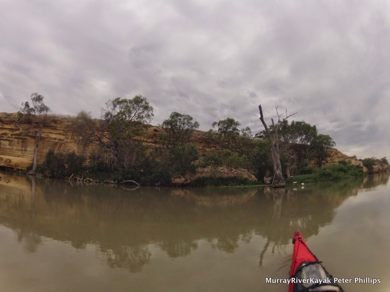
Day 29: Today was a day of headwinds from start to finish. The long straights funnel the wind and I just happened to be unlucky in their direction.


My first break was at Younghusband, an odd name, but also the name of a successful land agency all around Australia. Did the founder come from here? I wonder. At Younghusband there is a small caravan park, which has a small shop, which is where everyone meets, that and the truck load of dirt they have tipped near the river, sandbagged it so that it won't flow away and call it a beach. Even at this place of dubious quality, where the toilets are large concrete pipes with doors in them and you find yourself turning around looking for the thing you came in for. Even in this place, you don't walk into the store dripping wet and wearing a gorges lacked thermal and shorts in summer. Fashion crime! The owner looked me over twice, her eyes traceable as she went from top to bottom, and not believing it, did it again. I walked into her shop so she followed me. No she did not have fresh vegetables, only cans and frozen. I considered for a moment, but decided my ageing veggies were better than anything she had in the shop, but bought a pie, as if to show I was normal under all this garb. I don't know why I bothered, it didn't work, this caravan park diva was queen of all she surveyed - even if it was not much - it was hers and everyone came to her.

Younghusband was not a total loss. I met up with two young blokes who had raced past me in a small tinny earlier in the day and with whom I had stopped to chat, when I caught up with them again. This time they had two friends with them. Despite 4 in the small boat it still managed to plane at considerable speed. The boys had picked up hot chips and were about to head back to their shack, but stopped to chat. They were from Adelaide and just up for the weekend. When I mentioned that I was impressed with the speed of their boat, the owner informed me it was a 12 ft pelican, fibreglass and with a 25 HP motor (twice what it should have) and that it could do 50km/hr. on the back it had two huge beach fishing poles, each adorned with a Murray River flag. To make the boat look bigger and faster, I enquired? A smile came in return - of course. I liked these guys, they epitomise the good fun the river can be. As they left one of them asked, "is this as fast as you're going to go?" The driver cranked it up and they were off.

I cooked up some chicken noodle soup for energy and to get warm. The salts from the soup are good for electrolytes, the noodles are easy to digest and deliver slow release energy and the oils longer term energy. The warmth was good to, as I was soaked through and after a while, even with all the gear on, that cools you down. 30 kilometres done, another 20 to Mannum. Refreshed the headwinds seemed a lot more manageable.

Day 29: Finally a good shot of one of the many ferries that cross the river in SA. It's free, so you can go back and forth as many times as you want!

Day 29: The business end of the Marion.

In Mannum, just after the ferry and the magnificently restored paddle steamer, Marion is a huge park. The park stretched almost from one end of the town to the other, it had zones for paddle steamers, visiting houseboats, swimmers, speed boats and jet skis. It was full of people, locals and visitors alike. As I drifted in looking for a place to stop, a fella, Jeff, offered to give me a hand and suggested I pull in where he was, "there aren't any better places". I hauled me boat up the 1 metre high bank and then began to chat with him. He was reading car magazines and was supervising his grandson. He could keep an eye on the boat. I should visit the pub, the supermarket (we have a supermarket!) and the bakery in his opinion. I showed him my map and asked his opinion on my choice of campsite. Yep, that should be good - though he did keep forgetting what we had just talked about, so that was a mild concern. I took up his offer and strolled first through the park and then through town.


Randall's square boiler. On his first voyage it began to bulge. Randall wrapped bullock chains around the boiler and used wooden wedges to tighten them.
Stuff for sale: Mannum blacksmiths.


There are plenty of original buildings in Mannum. This town has character and charm.

I was so impressed with the park. Amazing what a small town of 3 - 5,000 people can do. It included historical monuments, band stands, room for everyone, and, in the middle of everything, a rowing club. Murray Bridge's rowing team, 'The Cods' represented Australia in the 1924 Olympics in Paris and being a neighbouring town, their would have been local rivalry. Directly behind the park is a row of old houses; all people's homes. Mannum seems to live its history. Walking up the hill to the main street, there are more old homes. Christmas carols are playing from speakers in the streets. The lamp posts are decorated with over sized tinsel and bells. My eye falls on the bakery and I walk in, order a coffee and a 'London Bun' as the girl behind the counter doesn't know what a coffee scroll is, and take in the scene. A couple of motor bike riders, in full leathers, two elderly couples who have just stepped out of a vintage car and a young family. Time is getting on, but I continue along the main street. One of the bikie guys is there. He introduces himself as Don. He used to come here as a kid,  as his parents had a shack up the river, and now had just come up from Adelaide for lunch. He said he often comes here to gaze at the river  and enjoy the atmosphere in town. Everyone is friendly and it relaxes him. Time to go. It turns out that Jeff is still watching my boat. Almost everyone else has gone from the park. 

Jeff used to be a dairy farmer, but all the local dairy farmers got out of the game. Falling milk prices and rising costs made government offers of water buy-backs hard to resist. He lived in Adelaide for a while, to be close to the kids, but came back because he likes the quiet here. Jeff told me to keep my eye out for a new marina development downstream from town. That used to be dairy farms, he said. You've still got a long way to go to the sea you know. I skied it once. Bloody near killed me.

Off again. 2 hours till camp at Woodside Reserve. The winds have dropped and only occasionally cause a bit of trouble. I arrive at camp about 6pm, change into dry clothes and begin to cook up something warm. The reserve seems to be set out for specific groups, but I can't seem to find the sign for canoeists paddling towards the sea, so I camped just the other side of a hedge. It doesn't seem like anyone lives in this town anyway. Perhaps it is all holiday homes, I thought. With this in mind, I cooked and ate under the members only sign on a cry nicely placed table and bench. 


Day 29: Campsite at Woodland reserve, downstream from Mannum.


Serenity... Except for that rumble. Out of the dark came the MV Proud Mary. It's spot lights scanning the bank. It pulled up 100m further down. It seems that Woodland Reserve is its home port. I had considered camping just next to their sign too. Glad I didn't. Those spot lights were strong!


Last day of the river tomorrow. Just under 60 kilometres to Wellington... And then we shall look at the lake.

Google+ Entire Photo Album


Day 28: 274 to 198 km to the sea: Blanchetown - Bolts Landing.


Day 28 - Saturday 15/12 

Blanchetown - Bolts Landing
River markers: 274 to 198 km from the sea.
Distance travelled today: 76 km. 
Total distance travelled: 1514 km

Facebook


Day 28: Goodbye Blanchetown and the last of the Locks (lock 1). The difference in height between the downstream side of lock 1 and Goolwa is only 75 cm. so there will not be much current for the next 300km.

Day 28: Interesting weather ahead.


The forecast for today was ominous, South Westerly winds 15 to 20 km/hr gusting to 40. I am on the section of the Murray which heads South. It has seen the promised land and wants to go to the sea. It does that by heading South - right into the wind. The first straight was 16 kilometres long, longer even than the one leading into Moorook. I decided to get up and leave early, since the winds are usually calmer in the mornings. Not so this morning. I woke at 5 am, tried to get a bit more sleep, but to no avail. A gale was blowing outside. I waited 30 minutes and then began to pack. Luckily, in this time the wind calmed and I was able to begin my day's journey in calm conditions. As heavy clouds were building and the forest predicted rain, I put on my heavy spray deck. As well as keeping out water much better than my summer spray deck (which only covers half the cockpit) it keeps me much warmer. Anything that keeps you warm when wet is welcome. 
Day 28: Aussie pride.

Day 28: Windmill against a dark sky. Leaving Blanchetown.

Day 28: River landscape: between Blanchetown and Big Bend.


I passed the point where Eyre made his camp 6 kilometres South of Blanchetown. It looked a nice spot, but a bit of a let down after the adventures of his great exploration. The South Australian government valued his ability to make peace with the aboriginal people, but it must have been lonely there. Perhaps Eyre did not want the city life, but he must have longer for educated conversation and recognition from his peers. Despite investing heavily in an irrigation scheme for the area, Eyre left for England only two years after taking his position at Blanchetown. What happened to him in England I do not know, but geographical societies were all the rage for gentlemen in those days and a man of his experience and good character would have been a sort after discussion partner for those wanting to learn about the colonies.

Day 28: Old irrigation pumps, downstream from Blanchetown.


Day 28: What shacks used to be like. Now they are more like condominiums.

Day 28: What shacks used to be like. Now they are more like condominiums.

Day 28: Big Bend. Between Blanchetown and Walkers Flat.


Day 28: 220km later, the cliffs are still spectacular.


Day 28: Headwinds, my constant companion since the river turned South.


In Swan Reach the river has a bend. Gasp! Finally! The cliffs on either side force it to. Rivers erode the banks on the outside of their bends, because there the force of the current is greater. They deposit sediment on the inside of their bends because the slower water there and edges cause it to drop sand and mud. Over time, the river moves through the space available to it, much like a hundred snake tracks. In the wide sections of the Murray, billabongs can be quite far from the river, as when the river takes a new track it has a lot of choices. Between these cliffs there is not so much room. If we were to watch its action sped up it would look like a writhing snake, trying to get out of its confines, but unable to, hitting one wall and then the next and repeating this over and over again. In Swan Reach, the cliffs are clearly visible on either side of the river, one forming one of its banks and the other a bit further away and every space in between is filled with billabongs. It is a paradise for wildlife to rival Kakadu.

Day 28: General store in Walker's Flat. Community hub, information and great chips! 


Old fishing signs: public and commercial.

Day 28: Afternoon light, Murray Cliffs, Walkers Flat.


The villages here have interesting names. Travelling along this section of river I passed through Moorunde, Portee, Kooloola, Punyelroo, Nildottie, Wongulla and Walker's Flat. In Walker's Flat I stopped, tempted by the nice green lawns next to the ferry and the possibility of a treat at the shop. In the shop was a sticker, "Where the bloody hell is Walker's Flat - down the road from Wongulla you idiot".  The Walker's Flat shop is a real community hub, where the owner, not only makes it his business to get people to talk together and share their stories, but also has local history on the walls of his shop. He was helpful in pointing out good camping sites and a few to avoid. He also makes very good hot chips :) . A fishermen burst in all excited whilst I was there, "My son just caught a catfish! You want to see a picture? It's a real beauty". The owner said he would like to put a copy of the photo up on the shop wall for all to see and would contact the local newspaper. The fishermen said that he had not caught a catfish in 20 years, when the river was a lot cleaner. He thought this was a sign of improving health in the river. Soon I was talking to the people at the table next to me and the young mum who came in, "Do you realise it is less than 6 weeks till the kids go back to school", he said teasingly. Some people are just what a small community needs. The owner told me that more and more people are travelling the river by kayak or canoe. Recently a man did the length of the Murray on a stand up paddle board. A young bloke with a bad back. He could not sit down. He completed the journey in 3 months. Hats off.


Day 28: Campsite at Bolts Landing.

Day 28: Campsite at Bolts Landing.

Day 28: Campsite at Bolts Landing.

Day 28: Campsite at Bolts Landing.


Day 28: Campsite at Bolts Landing.


Big Bend is as its name suggests, big. It took 16 kilometres to get around it. Camped somewhere on this bend was a friend I had made on Facebook and a member of the South Australian Marathon Canoe Club and I was looking for him. After 8 kilometres I found Darren and his 3 sons fishing. I pulled in and had lunch with them. These people are expert wind paddlers. Us 'upper Murray' paddlers have no idea how often and how strong the headwinds are here. If you have paddled the Murray 200, then you have had a taste of it. Darren accompanied me for 5 km before returning to his family. It was a nice gesture and actually the first time someone has paddled with me since I left Echuca 1500 km ago. The are a lot of quiet stretches of river out there. 

Following the Walker's Flat shop keeper's tip I found an excellent campsite at a place where a creek found its way between the cliffs called Bolts Landing. I don't know who Bolt is, but the present owner keeps sheep. Three herds have passed through my peaceful campsite already tonight! Apart from that small inconvenience, the view is spectacular. On the other side of the river farmland is bathed in gentle evening light, the ripples on the river catch the sunlight as sparkles, in the foreground are tall luxuriant growths of trees and the whole view is framed by old river red gums. Behind me limestone studded hills rise to join the cliffs that were before this place and continue on afterwards. Evening falls.

Day 28: Evening light at my Bolts Landing Campsite.


Google+ Entire Photo Album

  1. Walkers Flat 
  2. MDBC Native Fish Strategy 
  3. A guide to fish in the Murray Darling Basin

Day 27: 302 to 274 km to the sea: Pelican Point - Blanchetown.


Day 27 - Friday 14/12

Pelican Point - Blanchetown.
River markers: 302 to 274 km from the sea.
Distance travelled today: 28 km. 
Total distance travelled: 1438 km

Facebook

Day 27: River landscape between Morgan and Blanchetown.

There is something different about being in South Australia. The environment is more extreme. There is no hiding from the fact that you are in Australia. Many of the early Europeans wanted to tame the environment. You can see this in the planned towns of Renmark and Mildura, the streets are grid like. They have mathematical names and run at 90 degrees to each other regardless of the terrain. Pictures in Mildura's open air museum show with pride how trees areas were flattened by huge steam rollers and landowners proudly displaying their armies of steam engines in front of houses with gardens devoid of trees. In South Australia you can't afford to think like that. Water is too scarce, the environment too hot. All of it. I have the impression that people learnt quickly to work with nature, not against it, to learn from it.


Day 27: River landscape between Morgan and Blanchetown.


Day 27: Around Blanchetown the river is hemmed in between two more or less parallel cliff lines. It meanders between them, moving through all the available space over time, slowly making the gorge wider. As it moves it leaves backwaters like this one and billabongs which teem with life. A beautiful stretch of the river.


There is another difference, South Australians like to have their own minds. From the beginning they were different. A colony of thinkers. They were the only colony in Australia to have exclusively free settlers. Western Australia tried to go convict free, but had to give up. Adelaide was founded in 1836, 3 years earlier than Melbourne in 1839. The settlers came on a special passage of ships, like the first fleet that sailed to Sydney in 1788, but these were all paid migrants, keen to make a new start in a country away from the political, kingdom based skirmishes of Europe. What it would have been like to be amongst those first pioneers. I have included a sailors song from that time which captures the spirit, (Bound for South Australia) as a Youtube link on the Facebook page. It is sung like sailors, building bravado, not as pretty, or as nostalgic as many other versions. I feel the presence of those pioneers as I paddle down the river and walk through the old towns. What was it like? What is it like?


Day 27: Advertising for migrants to South Australia in 1836.


Blanchetown Hotel

Day 27: Advertising for migrants to South Australia in 1836.

I had lunch at the Blanchetown pub - the oldest in the Riverland - older than the Overland Corner by 2 years, the publican tells me, a smile on his face. "Mind you, they had to move the pub, stone for stone, because the rest of the town got washed away in the 1870 flood." Not good for customers. The first settlement was too close to the river, but then the 1870 flood was the largest on record (however there is evidence that in 1780, there was a much larger one). At Overland Corner the owner told me a story of an old aboriginal fellow who  refused to camp down near the hotel despite frequent invitations. He is said to have pointed to a tree trunk carried by the floods and left 8 metres higher than the Overlander. "You crazy. I not camping down there!" In the games room of the Blanchetown hotel are a series of paintings of the original settlement (called Moorundie, the name of the local Aboriginal Tribe). I have included one in the Facebook album. It shows a slab hut, with smoke coming from the chimney - a sign that everything is fine - and a clipper sailing up the river. This would have meant news from home, but also indicates the depth and width of the river here. 

Blanchetown lies on a significant boundary recognising the limits of human aspiration, the Goyder line. This line is the longstanding boundary of where crops can be sown and where only light grazing is possible. It was drawn up by South Australia's Surveyor General of the same name after repeated failure of settlements. In a two month ride Goyder used vegetation as a guide to rainfall and soil properties. Settlement was discouraged beyond the line. When good years came again the public pressured the government to abandoned the policy. Many of these places are now the ruins that are so picturesque when driving through the South Australian countryside. Everyone knows about the Goyder line here. The lady in the fish and chip shop-come hardware-come newsagent told me. It is a mark of pride to be living on the edge. Irrigation does change the picture a little though.

Day 27: Houseboats are beginning to look more like little ships as we near the sea. This one, a Halverson Cruiser looks almost like a 1930's destroyer. Very retro. Unfortunately, with the original petrol engine, they also had a habit of blowing up. Petrol fumes built up in the poorly ventilated hull were ignited by the flick of the starter switch. Not the beginning to a weekend on the river that you would hope.
Day 27: My kind of Christmas decoration. A tree full of short billed corellas.

Day 27: Corellas in flight.

Today I spoke to Franz Imhof. He paddled to the Murray from his hometown of then, Myrtleford, to Murray Bridge in 1968 with his brother. The year before the first Murray Marathon. His brother was in a Canadian canoe and he was in a kayak. Few kayaks were available that were designed for long distance journeys. Franz had gear on the front, gear on the back and wore a back pack as well. They did the trip around Christmas time. Franz said they got horribly burnt. They completed the trip in two months. In South Australia, Franz said they were often blown backwards, upstream by the wind. His brother liked the image if the bronze Aussie. We did not understand much about skin cancer back then. There was no such thing as sunscreen and Franz's brother liked to paddle without his shirt. He died of skin cancer shortly afterwards.

Day 27: The original settlement near Blanchetown, named Moorundi after the local aboriginal tribe followed the granting of the position of protector of aborigines to Eyre in reward for his exploration achievements. This picture from the Blanchetown hotel shows his hut and the first cutter to travel this far upstream, the Waterwitch. Eyre kept the peace, but the tribe dwindled and was extinct within 40 years, probably as a result of disease. The settlement, including its stone barracks and Eyre's own house succumbed to the Gundagai flood of 1850. The floods were named after the areas they came from and could be recognised by the colour of the water.

Day 27: Street art. Blanchetown.


Blanchetown is the first and last lock on the Murray. How will the current be from here? How long will the cliffs go on for? Are there really 90 metre high cliffs near Big Bend? Will the character of the Murray change as it nears the sea? The next three days will tell. By that time, all going well, I will be in Wellington and watching the heavens for signs signalling whether it is suitable to paddle Lake Alexandrina or not.

Time alone will tell.


Google+ Entire Photo Album