Day 19: 812 to 750 km to the sea: Beach Campsite - Lock 9 - Ned'sStation.


Day 19: Thursday 6/12

Beach Campsite - Lock 9 - Ned's Station
River markers: 812 to 750 km from the sea.
Distance travelled today: 62 km. 
Total distance travelled: 962 km


Day 19: Dawn: Camp between Mildura and Ned's Corner.


Day 19: River landscape downstream of Wentworth.

Day 19: Watching sheep.

Day 19: Stately old tree.

In stark contrast to the strong winds of yesterday I had perfect paddling conditions today. The sun shone in a blue sky and there was just the gentlest of breezes, perfect to keep cool. The strong sun would help my solar panel recharge my reserve battery too. They don't like cloud. 

I investigated a cutting in the first five kilometres, but it was blocked by about thirty metres of bank. The time it would take me to drag my heavy boat over was not worth the effort, or risk of injury, so I spun around and retraced my track through the tepid water. I enjoy investigating these little side tracks, even if they are blocked. There is something Amazonian about them. They teem with life. This one was so full of algae that when I paddled through it I left a track of bubbles. In following these on the way out I could be sure that I would not hit any hidden snags. Back in the main stream, I completed the extra four kilometres. One consolation was that I got to see a tributary of the Murray which I otherwise would have missed, called the Ana Branch (literally). The Ana Branch left the Darling 500 kilometres upstream. In times of flood a strong flow would come down these waters, today none was detectable, but its wide river bed commanded respect.

There are more Fisherman's huts on the river than I have seen so far. Some are simple lean-to's that have little more than a roof, four walls and a door, which must be unbelievably hot in summer. Some were communal, more gathering places than huts, with a roof shading collections of tables, a sink which drained onto the soil and simple light systems. Others were real little homes, with wire fenced gardens and water tanks on stands. One had a tin chimney, it reminded me of the huts that mountain cattlemen built in the high country for shelter during mustering times. Some were still in use. A hut set in behind the wreck of the paddle steamer Sapphire had two neatly moored boats. Others seemed abandoned. It was tempting to pull in and investigate.

Day 19: Fisherman's Shack. Communal version.
Day 19: Wreck of the Emerald barge downstream of Wentworth.

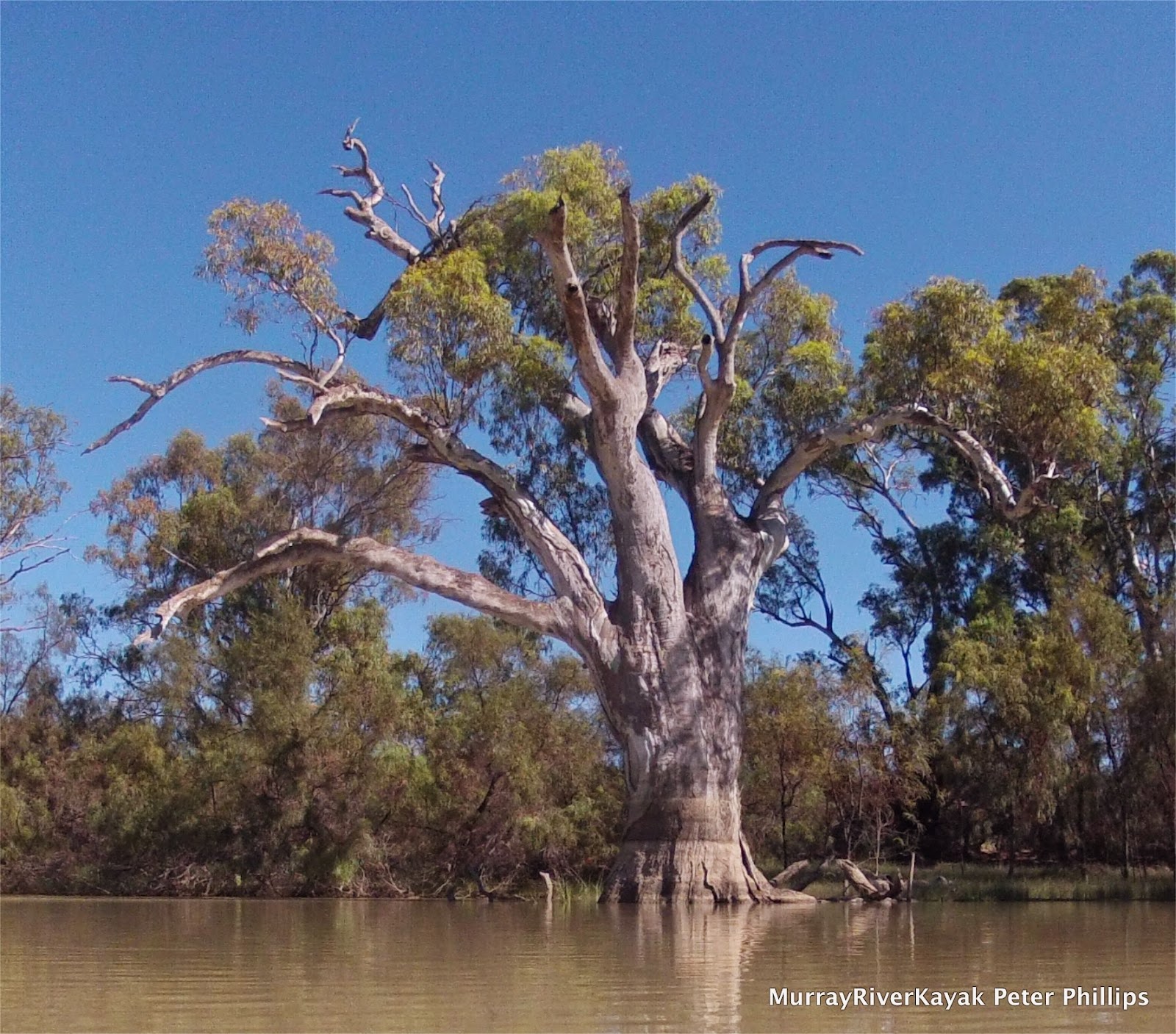
There were few of the red cliffs which had been a feature of the past few days, with only the occasional sandhill providing relief from the clay banks. It is about 70 kilometres from Lock 10 in Wentworth to Lock 9. This meant that the river was pooling. The closer you are to the next weir, the higher the water is and the lower the banks. Usually, there would also be no current, but with a good flow coming down the Darling, the current was running at between 1 and 2 km an hour. It may not seem like much, however it means that when I stop paddling instead of sitting still, I continue floating past the bank. It also lifts my speed. Every kilometre faster means an hour less on the water to cover the same distance in a day. Water birds love the high water levels. It floods the old billabongs and gives them safe breeding places. Fish breed amongst the water plants that thrive in the warm shallow waters of the billabongs too - so there is plenty to eat. Black swans and pelicans are my favorite larger water birds and today I did not go wanting. 
Day 19: River landscape downstream of Wentworth.

Day 19: Entrance to Lock 9.


I reached Lock 9 at about 1 pm and was lucky to be let straight through. I was lucky to get through at all, as the gates had been removed as part of a maintenance  program and had only just been put back in. John took me through the paces, chatting all the time, as is the custom. He informed me that the flow was 18,000 mega litres per day. This was 1,000 less than at Wentworth. The missing water would have been sent down Frenchman's Creek which is used to take water to Lake Victoria. Lake Victoria is South Australia's only water reserve on the Murray River. Although it is in New South Wales, there is an agreement between the two states. Just upstream of the weir was a large pumping station which diverts water to Lake Cullulleraine in Victoria for the same reason. It has a working steam engine which runs the original pump on special occasions. 

I rested under some young gum trees on a beach that had been roughened up by cattle. It wasn't very comfortable but it was out of the sun and this is a pull factor when you are out in it all day. I lay down and looked up through the leaves and became aware that they were full of pardalotes. Pardalotes are a tiny bird that usually lives high in the canopy. They are extraordinarily hard to see because they are shaped like leaves, almost have the same colour as gum leaves and fly from one leaf to another as if they were a falling leaf. They flit from leaf to leaf gleaning whatever insects may be there. They are the bird version of the the fish that clean the teeth of sharks on the Great Barrier Reef - the trees must love them. I watched these for some time, before dozing off. Awakening a short while later, I found one in a branch not 50 cm from me. An alarm call summoned most of them to an adjacent group of trees. The ones that stayed were a different species. Both spotted and striated pardalotes were feeding in the same trees in competition with one another. Drifting off again, I opened my eyes to find 5 young emus advancing for a look at me. You could tell they were a bit nervous because they would move their bodies forward and then their heads would follow. They would then strain for a really good look, before venturing even closer.

Day 19: Moorna Station. 48 km downstream of Wentworth.

I was taken by how relaxed the wildlife was, how seemingly unafraid they were of humans. Maureen Wright in her River Charts described the area between lock 9 and 8 as peaceful tranquility. Given that her last chart was drawn in 2001, it has been like this for some time. Reading ahead, I found that I was travelling through land managed by Ned's Corner, a station named after its one time shepherd, who used to gather the sheep in a bend in the river before taking them to market. The river acted as a fence and Ned only had to guard the bottleneck into the promontory. Today Ned's Corner is a Trust for Nature property. It is managed to maintain the diversity of local species by keeping their environment intact. The trust maintains the woodshed, stockyards and station as an example of how things were done in the time that this was a functioning station. Trust for nature employs local people, as well as resident caretakers. As far as I was concerned I had never paddled past such a beautiful and varied natural landscape. I saw many groups of emus, most with chicks and lots of kangaroos. The emus were not in a hurry to get away as they usually are and the kangaroos watched me, their wide ears focused, but were usually too lazy and comfortable to get up.

Whilst i took some time out to rest in the shade - away from the midday sun - a group of young emus decided that it would be time to have a look at me.


Day 19: River landscape near Ned's Corner Station.
Day 19: River landscape near Snake Island.


Evening was approaching and my tired body was telling me that it was time for camp and dinner. With no beaches around and a lot of mud, I found a spot where I could get out on some river red gum roots and dragged the boat up the bank. Using it as a seat I prepared dinner and then set up the tent. Can you imagine how nice it is to lie down after a full day of kayaking? 


Campsite near Snake Island. All of the banks were steep,
so I had to climb tree roots and drag my boat up over these as well.

Day 19: Snake Island campsite in the late afternoon light.


More from this expedition:

  • Google+  Murray River Paddle Echuca To The Sea Photo Album
  • Facebook Murray River Paddle
  • YouTube Murray River Paddle


More information about topics from this page:
  1. Trust for Nature: Ned’s Corner Station
  2. Barry and Maureen Wright's River Murray Charts
  3. Wentworth Shire Council: Moorna Station
  4. Wikipedia: MilduraWentworthList of crossings on the MurrayThe Darling River
  5. Discover the Murray:  Murray River Lochs, Dams and Barrages
  6. Murray Darling Basin Authority: Loch 9, Lake Victoria
  7. Environment Victoria: The Living Murray 
  8. Visit Mildura: Lake Cullulleraine.
  9. Ecology of Floodplain Lakes and Billabongs Lake Cullulleraine.
  10. Geology: Murray Valley Geography (A geological timeline of the development of the Murray).
  11. Victorian Geology: Tectonic Framework of the Lower Murray. (from Red Cliffs).
  12. ABC Mildura swan Hill: News and Community Events


Day 18: 882 to 812 km to the sea: Mildura - Wentworth - DarlingJunction - Beach Campsite.


Day 18: Wednesday 5/12

Mildura - Wentworth - Darling Junction - Beach Campsite.
River markers: 882 to 812 km to the sea.
Distance travelled today: 70 km. 
Total distance travelled: 900 km

Ready for the second half of the journey.


Mildura - Wentworth - 812km Beach: This part of the river uses navigation markers to show safe passage. The only problem is, when the buouy is in the middle of the river, which way should you go? The way I learnt to remember this when working on the square rigger, Eye Of The Wind, was when leaving harbour (going towards the sea in a river, ie. downstream) there is still plenty of red on board, the red is right. When coming into port there is only a little red left. :). So I went to the left of the the marker.


As I set off this morning there were pelicans on the beach, about 10 in all, cruising gracefully back and forth near to the water's edge. I get excited when I see pelicans, because it seems to mean to I am getting closer to the sea. I saw many pelicans during the course of the day, though usually they flew off too early to allow me to get a photo.
Day 18: rough weather

My first goal was a cutting about twenty two kilometres out. On the charts it was marked as shallow, but if passable it would save me eight kilometres. The day was windy, with rolling waves on the longer straights and bends. It was also pretty fresh to begin with, as I hit the water just before 8 am, it was still only 10 degrees celsius. Being wet in that kind of weather soon leads to hypothermia, so I had full wet weather gear, including my ocean spray deck. This tummy hugging spray deck made of wet suit material is heavy and warm, but in this kind of weather was just right. Using a tip on technique from a friend shared via Facebook, I managed to avoid the pains in my shoulders that had been troubling me the last few days - despite much more testing conditions. I reached the cutting in two and a half hours. It looked promising, but something must have been blocking it because not much water was flowing through. I advanced gingerly. I could see the exit, however I also saw the problem. Standing in the middle of the cutting, right where a fast flowing stream should have been, were 4 pelicans, their bellies well clear of the water. Just after this I came to a grinding halt - literally. With only 50 metres to go I decided that I was going to make this one way of the other. I succeeded in lifting the boat off the reef by pushing down with my hands on both sides of the boat. This action enabled me to move about twenty centimetres. not that impressive. I reconsidered my decision, but kept trying. Sometimes the movement was even less, however I was progressing. The pelicans had seen enough and took off. Eventually I got to deeper water, was stranded once more, but got off more easily this time. After five minutes and a lot of wiggling and lifting I was through. Success! 


Houseboat with wood fire stove.

The next straight, was full of houseboats. There are so many are around Mildura. Some look like pensioned off hire boats, however others were distinctly homemade. While some people like absolute luxury, with BBQ's like designer kitchens, others were very basic. one that appealed to me had three reclining lounge chairs on an open back deck, with a pot belly stove between them. Many had elements of paddle boats about them. The number of  small paddle steamers impressed me - each a connection with our past and as individual as their forebearers. As I got further and further away from Mildura, the number of houseboats, and people living along the banks of the river, got less and less. Gradually the bush took back over, the number of birds increased and I was on my own again. 
Abbotsford Bridge, connecting Yelta Vic, with Curlwaa NSW 1927.


Fishing boat in front of the wreck of the PS Sapphire.
Spectators


From the cutting my next goal was Wentworth and Lock 10. This was a further twenty-two kilometres away.  Originally I had planned to stay overnight at Wentworth, because I was worried about the strong winds and unsure how I would fare. I began to snack my lunch early to keep energy levels up and aimed to make Wentworth by 1 pm. Depending on how I felt I could decide whether to stay the night once I arrived. Feeling good, I arranged with Lockmaster Danny, to go through at 3 pm. This gave me enough time to walk into town and have a look around. 

Day 18: Counter Meal specials, Wentworth Pub.

The first thing I found was a bakery and ordered a pie and Big M. I love bakeries, they are traditional hubs in communities. In European villages, farmers families would bring in their flour once a week to be milled and then would bake their bread together in a communal, wood fired oven. This started early in the morning, well before dawn and would have finished late in the day. Everyone contributed flour, everyone shared the work and received  bread for the week. My father-in-law’s grandmother, her sight failing, once took the wrong sack. Instead of flour, cement was added to the communal mix. The villagers never let her forget it! The staff told with me where they had been in their tinnies and barbie boats when exploring the river, shared their favorite places, stories of floods and droughts and recommended a route for me to walk around town. I loved the verandas on the shops in the main street and the quirky seats with metal castings of native fish as back rests. The route took me by a small museum which was based on wooden models of paddle steamers built be a retired fellow called Rodney. They were amazing! One of his collections was of the paddle steamer Marion. Rodney had built a metre long model of every change in design that the Marion had ever had, from starting life as a barge, through to being a working cargo boat, to a whole range of ever more luxurious passenger carrying and entertaining features. We swapped some stories and then it was time to move on.

A short cut into the milky waters of the Darling River.

On my way into Wentworth, I had taken a short cut into the Darling River. The Darling joins the Murray at Wentworth. Two great rivers, said to be one river system, but both based on completely different climate patterns and flowing through different soil types. The big surprise is that the Darling is milky white: almost the colour of concrete. The Murray in comparison, was a dark green. We get used to calling the Murray dirty, but it carries a lot less clay than does the Darling. Where they meet, just upstream of the weir the two different coloured waters flow side by side. It is surreal. These then mix in the weir. As I went through the lock, foam from the water pouring over the weir blew up into the air and into the lock. It was almost like being at the sea. The Lockmaster, Danny said that Darling water tends to do that. I wonder if it was due to the water having a higher salt content than the Murray. In any case within a few hundred metres, everything had settled - but the Murray had changed colour. 

Danny informed me that at the moment 19,000 megalitres of water were flowing through the weir. This was 7,000 more than at Torrumbarry and due to rising water in the Darling from good rains in central Queensland about six weeks before. Rises of seven feet were expected in the Darling, much less in the wider Murray. I pulled my boat up a little higher than usual and tied it on, just in case. 
Inside Lock 10.
Lock 10 Wentworth chatting with Danny.
Day 18: Below the point where the Darling River enters the Murray the river changes colour, taking on the milky white of the clays of the Darling basin. This colour remained almost until Lake Alexandrina.
Day 18: Wentworth's dedication to the humble grey Fergie that saved the town.
Day 18: Benches celebrating local fish, this one is a catfish.


In 1956, massive floods came down both the Murray and the Darling rivers. The people of Wentworth, with a river each side of them were trapped. They managed to save the town by building huge levees all around. Local residents and farmers worked round the clock with their tiny Massey Ferguson tractors to build the wall, one little tractor scoop at a time. These really were small tractors, some people have ride on lawn mowers as big as a Massey Ferguson. It was a massive effort. In recognition there are monuments around town to the Little Grey Fergie and a garden memorial to it as well. 

Day 18: Rodney with his model paddle steamer display in Wentworth.

Rod and Chris in the model paddle steamer display museum told me of the last two paddlers to pass through - it seems everyone stops at their shop. One was 18 year old Chris Hayward, (doing the length of the Murray), who want it or not, received a good dose of fatherly advice from the gents. The other was a fella who they thought might be 35, who had done the length of the Darling. He had dreadlocks, they said. I wonder if that is what the Darling does to you? 

Young emus coming for an inspection.

I continued on another twenty kilometres to a comfortable beach at the 812 kilometre mark, exactly 900 kilometres from Echuca and back on schedule. I was really happy with today's paddle. Despite very little, or no current and a strong head wind for most of the day, I still managed to get my distance done. This helps me to feel more confident for the second part of the journey, where current is said to be almost non existent and head winds common.

Day 18: Camp between Mildura and Ned's Corner.


More from this expedition:

  • Google+  Murray River Paddle Echuca To The Sea Photo Album
  • Facebook Murray River Paddle
  • YouTube Murray River Paddle


More information about topics from this page:
  1. Visit Victoria:  Mildura,
  2. Visit Wentworth; Visitor information
  3. Australian Explorer: Rodney Hobb's Paddlesteamer Display
  4. Wikipedia: Mildura, WentworthList of crossings on the Murray, The Darling River
  5. Discover the Murray: WentworthMurray River Lochs, Dams and Barrages
  6. Murray Darling Basin Authority: Loch 10
  7. Environment Victoria: The Living Murray 
  8. Geology: Murray Valley Geography (A geological timeline of the development of the Murray).
  9. Victorian Geology: Tectonic Framework of the Lower Murray. (from Red Cliffs).
  10. ABC Mildura swan Hill: News and Community Events


List of crossings on the Murray River

Day 17: 882 km to the sea: Mildura - Rest Day


Day 17: Tuesday 4/12

Mildura - Rest Day
River markers: 882 km from the sea.
Distance travelled today: 0 km. 
Total distance travelled: 830 km


A restful day: beginning with breakfast on a balcony with a real table and chair.
Great to see Ruth once again.

Time the title of this expedition was written on the boat.


And my name :).


Mildura's hot mediterranean climate is reflected in its choice of street trees.
Enjoying normal clothes and a day in town.

Catching up on history: the Chaffey Trail.


...and some of the more unusual stories.
Mildura - someone dropped £1,600 if gold, silver and bronze taken to Midura to open a new bank in the river. Oops.

Mildura: the saloon of the Ellen in 1890. Most journeys in comfort to the new irrigation properties of Mildura included at least one segment by Paddlesteamer.

Mildura: isolation and little income ment resourcefulness was necessity. Old ideas find new footings. This is a 'torkel', a wine press used by the farmers along Lake Constance on the Swiss-German border area of Hagnau. The originals were made of oak trees.

Mildura: first bank.

Mildura: Gol Gol Annual Picnic Sports, Boxing Day 1912. Creative water craft.

Mildura: how to get to the irrigation colonies in the 1880's.

Day 17: Mildura: more creative watercraft. A hand driven paddle boat.

Mildura: Ruth and I at Trentham Winery celebrating half way.


Mildura: Trentham Estate Winery. http://www.trenthamestate.com.au/
Locals: Apex bend caravan park, Mildura.

Lovely end to a restful day.


More from this expedition:

  • Google+  Murray River Paddle Echuca To The Sea Photo Album
  • Facebook Murray River Paddle
  • YouTube Murray River Paddle


More information about topics from this page:
  1. Visit Victoria:  Mildura
  2. Wikipedia: Mildura
  3. Discover the Murray: Loch 11 and the Chaffey TrailMurray River Lochs, Dams and Barrages
  4. Goulburn Murray Water: Loch 11
  5. Environment Victoria: The Living Murray 
  6. Trentham Estate Winery
  7. Geology: Murray Valley Geography (A geological timeline of the development of the Murray).
  8. Victorian Geology: Tectonic Framework of the Lower Murray. (from Red Cliffs).
  9. ABC Mildura swan Hill: News and Community Events