Day 21: 682 to 602 km from the sea: Devils Elbow - Lock 6 - Wilkinson’sCutting.


Day 21: Thursday 8/12

Devils Elbow - Lock 6 - Wilkinson’s Cutting
River markers: 682 to 602 km from the sea.
Distance travelled today: 80 km. 
Total distance travelled: 1120 km


Day 21: Early morning starts to avoid the heat have their consolations - calm water and beautiful reflections. — at Downstream from Devils Elbow, Murray River.


A great day’s paddle today. Almost my PB. 80km and in camp by 3pm. Must do more of these early starts.

The plan was to get off early today since high temperatures and strong South-Westerly winds are expected in the afternoon. South-West is the direction I will be headed in the afternoon. So the best thing it seems to me would be to be where I need to be by about 2pm. I can then sit out the heat in the water. Just have to pick a safe beach. I don't have the most up to date forecast as I have no reception here, but I can feel that something is building in the air. 

I managed to get off at 6:25 am, my earliest start yet. At Pollards Cutting (672 km mark) and I have been on the water for almost an hour, trying to beat the heat and predicted wind change. So far I have been making good time. P.S. Marion hit a snag here and the P.S. Gem hit a snag and sunk on 6 November 1948, only a few kilometres further down the river. Unable to make it to the bank, the Gem sunk in five metres of water. All of the passengers were safely transferred to shore, though one gentleman, is reputed to have died of fright. Keighley Goodchild, editor of the Echuca Advertiser (forerunner of the Riverine Herald) published a book of poems in 1882 called ‘While the billy boils’. He also published his writings in the local paper, as was common practise at the time. Amongst his poems was one about the sinking of a paddle steamer on the Murray. Children used to learn it at school as part of their appreciation of Australian literature. It includes all the drama of fighting for the vessel and fear of life and limb. After an epic battle the crew lose, the captain gives the command to abandon ship - and everyone walks ashore. Ach, the Murray. 


Source:

I sing of a captain who's well known to fame,

A naval commander, Bill Jinks is his name,
Who sailed where the Murray's clear waters do flow,
Did this freshwater shellback with his Yo, Heave a Ho.

To the port of Wahgunyah his vessel was bound,

When night comes upon him and darkness around,
Not a star in the waters its clear light did throw,
But the vessel sped onwards with a Yo, Heave a Ho.

"O Captain, O Captain, let's make for the shore,

For the winds they do rage and the waves they do roar."
"Nay, nay," said the Captain, "The fierce winds may blow,
I will stick to my vessel, with a Yo, Heave a Ho."

"O Captain, O Captain, the waves sweep the deck,

O Captain O Captain, we'll soon be a wreck.
To the river's deep bosom the seaman will go."
But the Captain laughed lightly, with a Yo, Heave a Ho.

"Farewell to my mates and the girl I adore,

Farewell to my friends, I shall see them no more."
The crew shrieked with terror, the Captain he swore,
They'd stuck on a sand bank, so the crew walked ashore.


By Keighley Goodchild
Goodchild was born in London in 1851. He died in Echuca in 1888, only 37. He is buried in the Echuca cemetery.  Auslit ref

Shortly after the site of these two sinkings, I came across the most happily situated station. Kulcurna Station (formally Lindsey Cliffs) is beautifully located. Set at the base of solid vertical cliffs where the sloping land meets the plains, it is nestled in amongst shady trees. In the shade of these trees and running up to the wired-in verandas that surround the house are modest, but lush green lawns. An Australian flag is flying but all else is quiet. A kangaroo, having breakfast in the green grass raises its head to look at me as I drift past. The light reflecting off the cliffs has a warm glow to it. The feeling of serenity is enhanced by the last of the morning chorus and the feeling that out here, both in the natural and human world there is no rush yet. The bush around me is so full of the sound of bird calls that I am reminded of my times working in the Daintree Rainforest of Far North Queensland. It has an echoing quality, each sound bouncing off the next, each call set to be heard above others. It is staggering. I stop to listen, take it in consciously, appreciate. At the base of the cliffs names are carved. One has ‘97 next to it. After the people are gone the names will still be there. Maybe they have gone, grown up, left for uni, or jobs in the city, however I think once you have lived at this place, part of your being will always be there. I have since heard that the family no longer live in this house, but in a more modern one,
 a little further back from the river. They rent this one out to people wanting a bit of R & R. So it's my hot tip!

Day 21: The cliffs at Kulcurna Station. — near Cal Lal, New South Wales.

Day 21: Old pump house. Kulcurna Station.


I did not think there would be much to see on today's stretch. I had trouble picking highlights from the map, but once in the water, they just kept coming. On passing the site of the ruin of Cal Lal Police Station (659 km mark), something caught my eye and I just had to turn around. All that remains of the police station is the dunny - though this was built so securely that I wonder whether it was also used as the lockup? Imagine what problems that would have caused! I have taken a photo and will upload it once reception is good enough - then you can judge for yourself.


Day 21: All that remains of Cal Lal Police Station... actually, found out later that the station is on higher ground, this may have been their toilet... or other such room of requirement.


Day 21: Millewa Station

At Higgins Cutting I got a big, two handed friendly camper wave from someone sitting in their deck chair enjoying the early morning light. It is amazing how when people are friendly it lifts your spirits. I had more friendly people today, some campers setting up for a weekends fishing, houseboat people and as always, the lockmasters. Thanks people, you make a difference!


Day 21: cliffs near Chowilla Station


At Chowilla Station Customs House there is a boat ramp where you can pull into and a very basic shop.
There is where you can find out more about the Chowilla Biosphere Reserve, a river island used for decades to dump salt from irrigated pastures in South Australia. Despite destroying the original vegetation, the resultant salt marsh is a haven for water birds and an adventurous canoeists paradise. Chowilla station now caters for groups and families, with the shearers quarters available for accommodation. Chowilla Station.
Chowilla and Bookmark Game Reserve Management Plan.
Paddling in Chowilla: Canoe South Australia
Riverland Nature trails Brochure:
Chowilla Station.
Chowilla Station.
Source


Border Cliffs Customs House


Passing the border signs was special. First, I left New South Wales, then about eight kilometres later, Victoria. In each case the border is the southern bank, so Victoria gets none of it. The borders are marked with an old fashioned wooden sign, one, easily accessible, was covered with names and dates in the pole. The sign was unmarked. On the Victorian side, the sign was in a swamp, which meant no-one could get to it. I am not sure which I prefer. I think the one with the signatures, because I can empathise, I too am proud of getting this far.
Day 21: South Australia - NSW border, with signatures as a record all over the post.

Day 21: SA: VIC border sign in a swamp! Great!

Day 21: SA: VIC border sign in a swamp! Not so accessible!


Day 21: River Landscape.


Day 21: Camp kitchen sheltered from stormy winds. All the food and cooking gear is in the front hold (the kitchen). All the camping gear, clothing, wet weather gear, wheels etc. is in the back (the garage).


Camp at Wilkinson's Cutting is another beautiful site with a view of the red cliffs below Wilkadene station. It has been a hot day and a strong dry wind is blowing. Kids from the station are cooling off in the water. I can hear their excited shrieks carrying through the air as they plunge and splash in the refreshing waters of the river. I am off to do the same.


More from this expedition:

  • Google+  Murray River Paddle Echuca To The Sea Photo Album
  • Facebook Murray River Paddle
  • YouTube Murray River Paddle


More information about topics from this page:
  1. Kulcurna Station: History, Local Information and Photography, YoutubeABC Interview
  2. Dept Heritage & Env NSW Aboriginal History after occupation of their lands in the 1800's
  3. AustLit: Keighley Goodchild: Literary Works
  4. Shire of Wentworth: Cal Lal Police Station
  5. Motorcycle meanders: tracing old mail routes of the 1850' and 60's along the Murray
  6. Millewa Park Pioneer Forest and Historical Village: Pioneers 
  7. Barry and Maureen Wright's River Murray Charts
  8. NSW DPI Lower Murray River aquatic ecological community , pdfwebsite
  9. Dept Env & Conservation.:  Aboriginal Scar Trees in NSW: A Field Manual
  10. Dept of the Environment: Biodiversity Species Profile and Threats Database.
  11. Murray Darling BasinPeopleEnvironmentEconomyRiversSharing WaterMDBA
  12. Environment Victoria: The Living Murray 
  13. La Trobe University: Chowilla Dam (transcript, podcast)
  14. Discover the Murray: Chowilla Dam Project, Guide to sustainable and safe camping.
  15. Geology: Murray Valley Geography (A geological timeline of the development of the Murray).
  16. Victorian Geology: Tectonic Framework of the Lower Murray. (from Red Cliffs).
  17. ABC Mildura Swan Hill: News and Community Events


Day 20: 750 to 682 km to the sea: Ned’s Corner Station - Devils Elbow.


Day 20: Friday 7/12

Ned’s Corner Station - Devils Elbow.
River markers: 750 to 682 km from the sea.
Distance travelled today: 68 km. 
Total distance travelled: 1040 km


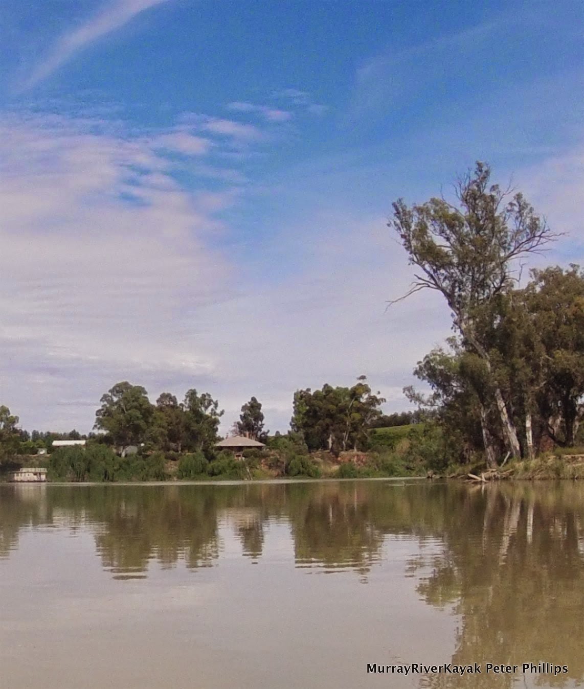
Day 20: Early morning reflections, Ned's Corner Station.


Off early today. It is 7:20 am and I am about to hit the water. Morning light is beautiful and I may catch animals coming down to drink still if I am lucky :). I was camped opposite Snake Island on Ned's Corner Station property. It was true that I was tired when I pulled up, but I also could not paddle past so much beauty. I had to be a part of it. This morning's perfect reflections with Snake Island in the background were part of that experience. Pelicans are flying in formation overhead and there is still the last part of the morning chorus happening. There is no wind, but the sound of bees provides background noise, so loud that you could be forgiven for thinking they were the sound of traffic, were I in the city. The trees must be full of them.


Day 20: Celebrating 1,000km!


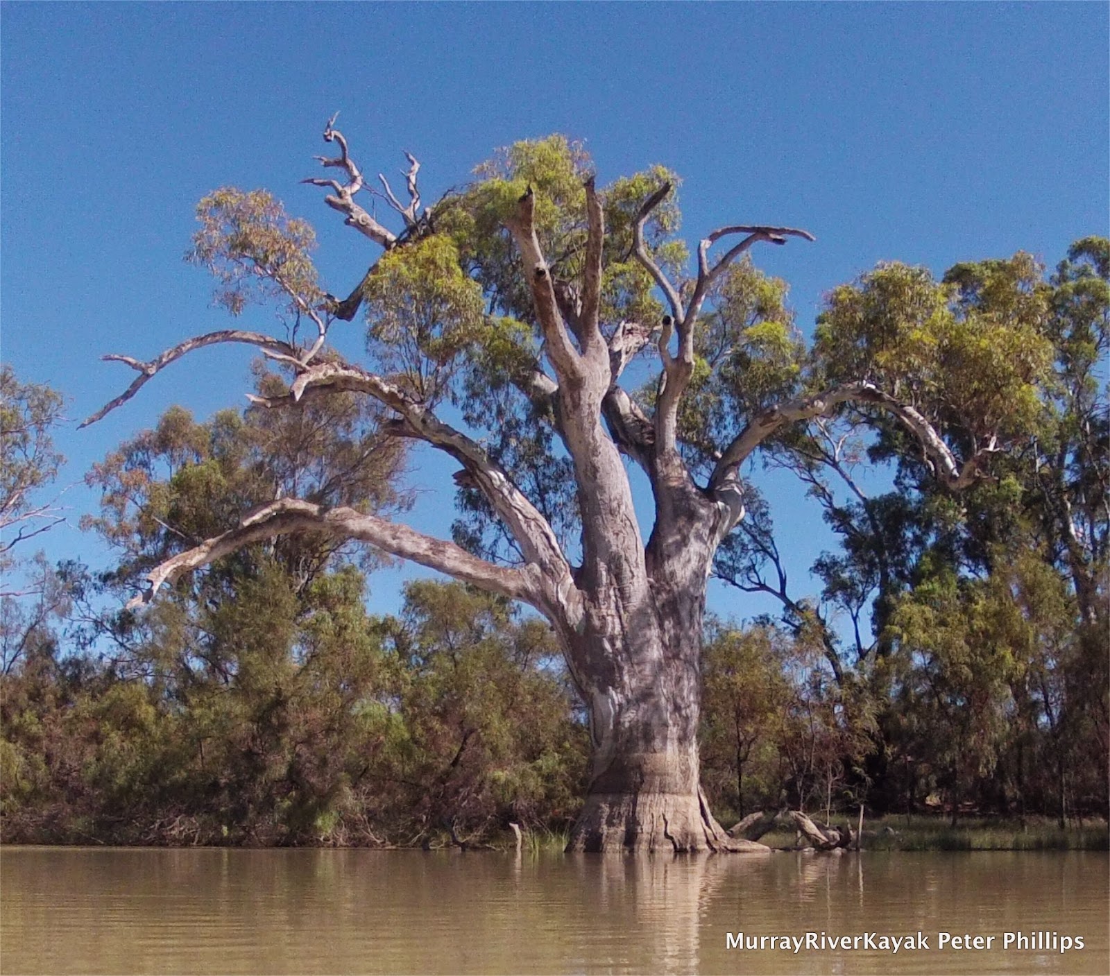
In this section of river old river red gums line the banks. Behind them Mallee, box, salt bush, lignum, wattle, hakea and melaleuca create a diverse environment for a whole community of animals.

Andrew Cook, acting lockmaster at lock 9 is also a qualified shipwright. He did his apprenticeship under Kevin Hutchinson in Echuca and is currently refitting the Daisy. He has built almost all of the paddle steamers around here according to the lockmaster at lock 8. When I asked him how it is to be a lockmaster, he said that he loves it, wouldn't swap it for the world. It is stress less and you get to talk to people and everyone is friendly. He said I should call in on Peter Clark at Ned’s Corner Station. When I said that I was concerned about intruding, he answered, “Don't worry about that, this is the river, people are interested in each other, they drop in all the time. It's what we do”.

15,000 Megalitres was passing through lock 8. This is less than at lock 9 despite no major channels leaving the river in that time. This indicates that I am now pushing ahead of the main flow That is still coming down the Darling River.

Day 20: Pulled in to say "gidday" at Ned's Corner Station.

Day 20: Trust for Nature Ranger Anthony Pay in front of his trophy wall - fox and cat tails from 2012.

On recommendation from the lockmaster at Lock 8, I pulled into Ned’s Corner Station. Anthony Pay, a trust for nature ranger generously showed me around. Highlights were the old shearing shed, several rooms in old sheared quarters showing local history, and Anthony's trophy wall of fox and cat tails. A small railway used to lead from the shearing shed to the river to wash the wool and also to load it onto paddle steamers. All the local farmers used to drove their sheep here, rather than cart the wool by dray to the next town. There is a photo of the P.S. Marion with a load of wool and another of a paddle steamer with the wool bales stacked six rows high. 

Day 20: Old shearer's bikes, Ned's Corner Station. The shearer's used to ride on the dusty tracks, swag over shoulder, from job to job.

Day 20: Shearing Shed, Ned's Corner Station.

Day 20: Shearing Shed, Ned's Corner Station.

Everywhere the buildings have wide verandahs, the older ones also with fly screens, to have somewhere cool to sit - days before air-conditioning.

The station is set up for groups, with different types of accommodation, in the homestead or self catering. Conservation and land management students from La Trobe University in Bendigo come here in their final year, but Anthony says they have so much to do that some do not even get time to take a look around. Some don't even make it to the river, but spend all the time in their room trying to answer the questions that the lecturers have set them. 

Much of the material in the displays has been gathered by rangers at the station, found where it was left out in the paddocks, or where it fell under the floor-boards of the shearing shed. 


Day 20: Trust for Nature Ranger Anthony Pay's shooting ute.

Day 20: Trust for Nature Ranger Anthony Pay's shooting ute... .... With visitors lounges.
Day 20: Leaving Ned's Corner.


Trust for Nature took over the property ten years ago. They have restored the homestead, are working on the sheering shed, have planted 10’s of thousands of trees and are putting in rabbit and fox proof fencing in some areas.

For his evening entertainment, Anthony shoots foxes and cats. In his modest home at the station a whole wall is lined with fox and cat tails, on a desk in his fly-wired porch he is salting five more from last night. It doesn't seem to make a difference in the numbers he said, but I might have given a few lizards and birds a bit more of a chance.

Day 20: The river is wide between Mildura and Renmark.

Through the weir now. Got out and had a chat to Mick, the lockmaster, who lives here with his wife and kids. Like the other weir managers, he also loves the job. There are 17,000 megalitres flowing through the weir. The drop is only about 30cm, another sign that the river is up. Mick says that the water is unusually milky because of the Darling’s contribution. It will clear up again when they cut the flow from the lock below the Menindee Lakes. 


Day 20: Pelicans circling in thermals overhead. They seem to like the wide river, especially when there are shallow billabongs to fish in nearby.

He says that there is an old fella around here who remembers when the water was absolutely clear. He used to go spear fishing. He remembers seeing catfish nesting on the sand bars, swimming round and round their eggs. Since weirs have gone in (and some say, also since the carp have arrived) the water is not clear anymore. However, back before the weirs the river used to stop flowing every year and also have quick devastating floods. With the weirs and dams we have a river that flows all year round. Since the Hume dam was built there has always been some flow. Before it was built it was common for the Murray to stop flowing in summer. In Swan Hill it stopped flowing for a whole month in the 1914-15 drought. Apart from the safety of the towns and the benefits to recreation, Australia could not support the population it has if the river was not regulated and its land irrigated.


Day 20: Summer clouds.

Made it! And still feeling good. Tired but good. I am at the most amazing campsite. The Devil's Elbow (682 kilometre mark). It is a large sandy beach with shade from the setting sun and a view onto spectacular sandstone cliffs that are crumbling as I watch. The cliffs have been formed by the river cutting into soft sedimentary rock on the outside of its bend. The rocks have clear horizontal strata. The bottom layer extends to about 3 meters above current river level and is a light purple tending towards pink at the top. The next layer is a more solid golden sandstone, only 30 cm thick and tending to break off in chunks. There are then layers of green, white and yellow extending to 20 m in places. All of these layers are topped by what looks like wind blown sand. The erosive action of water has given the highest parts a rounded shape and created deep canyon like furrows between them. When the wind blows, as just now it becomes trapped by the cliff wall, sometimes building vertical spirals of dust. The river is quite narrow here, as it slams into the cliff. A contrast to the predominantly flat, forest lined landscapes of the area.

Just another bit of information about the devils elbow. At the time of paddle steamer trade, the bend was so difficult to navigate, so tight, that skippers travelling downstream preferred to turn around upstream and go down backwards. There was less danger of being swept into the rocks that way.

As with so many stretches along here, there is no reception. I will try and post this one in the morning.


Day 20: Devil's Elbow campsite. — at Nampoo Station, NSW.


More from this expedition:

  • Google+  Murray River Paddle Echuca To The Sea Photo Album
  • Facebook Murray River Paddle
  • YouTube Murray River Paddle


More information about topics from this page:
  1. Trust for Nature: Ned’s Corner Station
  2. Barry and Maureen Wright's River Murray Charts
  3. National Library of Australia: Murray waters held up. The Advertiser (Adelaide) Tue 8 Dec 1914.
  4. Flickr:  Devil's Elbow
  5. Australian Journal of Earth Sciences: Geology of the Rainbow Cliffs of Devil's Elbow.
  6. Environment Victoria: The Living Murray 
  7. Ecology of Floodplain Lakes and Billabongs 
  8. Geology: Murray Valley Geography (A geological timeline of the development of the Murray).
  9. Victorian Geology: Tectonic Framework of the Lower Murray. (from Red Cliffs).
  10. ABC Mildura swan Hill: News and Community Events


Day 19: 812 to 750 km to the sea: Beach Campsite - Lock 9 - Ned'sStation.


Day 19: Thursday 6/12

Beach Campsite - Lock 9 - Ned's Station
River markers: 812 to 750 km from the sea.
Distance travelled today: 62 km. 
Total distance travelled: 962 km


Day 19: Dawn: Camp between Mildura and Ned's Corner.


Day 19: River landscape downstream of Wentworth.

Day 19: Watching sheep.

Day 19: Stately old tree.

In stark contrast to the strong winds of yesterday I had perfect paddling conditions today. The sun shone in a blue sky and there was just the gentlest of breezes, perfect to keep cool. The strong sun would help my solar panel recharge my reserve battery too. They don't like cloud. 

I investigated a cutting in the first five kilometres, but it was blocked by about thirty metres of bank. The time it would take me to drag my heavy boat over was not worth the effort, or risk of injury, so I spun around and retraced my track through the tepid water. I enjoy investigating these little side tracks, even if they are blocked. There is something Amazonian about them. They teem with life. This one was so full of algae that when I paddled through it I left a track of bubbles. In following these on the way out I could be sure that I would not hit any hidden snags. Back in the main stream, I completed the extra four kilometres. One consolation was that I got to see a tributary of the Murray which I otherwise would have missed, called the Ana Branch (literally). The Ana Branch left the Darling 500 kilometres upstream. In times of flood a strong flow would come down these waters, today none was detectable, but its wide river bed commanded respect.

There are more Fisherman's huts on the river than I have seen so far. Some are simple lean-to's that have little more than a roof, four walls and a door, which must be unbelievably hot in summer. Some were communal, more gathering places than huts, with a roof shading collections of tables, a sink which drained onto the soil and simple light systems. Others were real little homes, with wire fenced gardens and water tanks on stands. One had a tin chimney, it reminded me of the huts that mountain cattlemen built in the high country for shelter during mustering times. Some were still in use. A hut set in behind the wreck of the paddle steamer Sapphire had two neatly moored boats. Others seemed abandoned. It was tempting to pull in and investigate.

Day 19: Fisherman's Shack. Communal version.
Day 19: Wreck of the Emerald barge downstream of Wentworth.

There were few of the red cliffs which had been a feature of the past few days, with only the occasional sandhill providing relief from the clay banks. It is about 70 kilometres from Lock 10 in Wentworth to Lock 9. This meant that the river was pooling. The closer you are to the next weir, the higher the water is and the lower the banks. Usually, there would also be no current, but with a good flow coming down the Darling, the current was running at between 1 and 2 km an hour. It may not seem like much, however it means that when I stop paddling instead of sitting still, I continue floating past the bank. It also lifts my speed. Every kilometre faster means an hour less on the water to cover the same distance in a day. Water birds love the high water levels. It floods the old billabongs and gives them safe breeding places. Fish breed amongst the water plants that thrive in the warm shallow waters of the billabongs too - so there is plenty to eat. Black swans and pelicans are my favorite larger water birds and today I did not go wanting. 
Day 19: River landscape downstream of Wentworth.

Day 19: Entrance to Lock 9.


I reached Lock 9 at about 1 pm and was lucky to be let straight through. I was lucky to get through at all, as the gates had been removed as part of a maintenance  program and had only just been put back in. John took me through the paces, chatting all the time, as is the custom. He informed me that the flow was 18,000 mega litres per day. This was 1,000 less than at Wentworth. The missing water would have been sent down Frenchman's Creek which is used to take water to Lake Victoria. Lake Victoria is South Australia's only water reserve on the Murray River. Although it is in New South Wales, there is an agreement between the two states. Just upstream of the weir was a large pumping station which diverts water to Lake Cullulleraine in Victoria for the same reason. It has a working steam engine which runs the original pump on special occasions. 

I rested under some young gum trees on a beach that had been roughened up by cattle. It wasn't very comfortable but it was out of the sun and this is a pull factor when you are out in it all day. I lay down and looked up through the leaves and became aware that they were full of pardalotes. Pardalotes are a tiny bird that usually lives high in the canopy. They are extraordinarily hard to see because they are shaped like leaves, almost have the same colour as gum leaves and fly from one leaf to another as if they were a falling leaf. They flit from leaf to leaf gleaning whatever insects may be there. They are the bird version of the the fish that clean the teeth of sharks on the Great Barrier Reef - the trees must love them. I watched these for some time, before dozing off. Awakening a short while later, I found one in a branch not 50 cm from me. An alarm call summoned most of them to an adjacent group of trees. The ones that stayed were a different species. Both spotted and striated pardalotes were feeding in the same trees in competition with one another. Drifting off again, I opened my eyes to find 5 young emus advancing for a look at me. You could tell they were a bit nervous because they would move their bodies forward and then their heads would follow. They would then strain for a really good look, before venturing even closer.

Day 19: Moorna Station. 48 km downstream of Wentworth.

I was taken by how relaxed the wildlife was, how seemingly unafraid they were of humans. Maureen Wright in her River Charts described the area between lock 9 and 8 as peaceful tranquility. Given that her last chart was drawn in 2001, it has been like this for some time. Reading ahead, I found that I was travelling through land managed by Ned's Corner, a station named after its one time shepherd, who used to gather the sheep in a bend in the river before taking them to market. The river acted as a fence and Ned only had to guard the bottleneck into the promontory. Today Ned's Corner is a Trust for Nature property. It is managed to maintain the diversity of local species by keeping their environment intact. The trust maintains the woodshed, stockyards and station as an example of how things were done in the time that this was a functioning station. Trust for nature employs local people, as well as resident caretakers. As far as I was concerned I had never paddled past such a beautiful and varied natural landscape. I saw many groups of emus, most with chicks and lots of kangaroos. The emus were not in a hurry to get away as they usually are and the kangaroos watched me, their wide ears focused, but were usually too lazy and comfortable to get up.

Whilst i took some time out to rest in the shade - away from the midday sun - a group of young emus decided that it would be time to have a look at me.


Day 19: River landscape near Ned's Corner Station.
Day 19: River landscape near Snake Island.


Evening was approaching and my tired body was telling me that it was time for camp and dinner. With no beaches around and a lot of mud, I found a spot where I could get out on some river red gum roots and dragged the boat up the bank. Using it as a seat I prepared dinner and then set up the tent. Can you imagine how nice it is to lie down after a full day of kayaking? 


Campsite near Snake Island. All of the banks were steep,
so I had to climb tree roots and drag my boat up over these as well.

Day 19: Snake Island campsite in the late afternoon light.


More from this expedition:

  • Google+  Murray River Paddle Echuca To The Sea Photo Album
  • Facebook Murray River Paddle
  • YouTube Murray River Paddle


More information about topics from this page:
  1. Trust for Nature: Ned’s Corner Station
  2. Barry and Maureen Wright's River Murray Charts
  3. Wentworth Shire Council: Moorna Station
  4. Wikipedia: MilduraWentworthList of crossings on the MurrayThe Darling River
  5. Discover the Murray:  Murray River Lochs, Dams and Barrages
  6. Murray Darling Basin Authority: Loch 9, Lake Victoria
  7. Environment Victoria: The Living Murray 
  8. Visit Mildura: Lake Cullulleraine.
  9. Ecology of Floodplain Lakes and Billabongs Lake Cullulleraine.
  10. Geology: Murray Valley Geography (A geological timeline of the development of the Murray).
  11. Victorian Geology: Tectonic Framework of the Lower Murray. (from Red Cliffs).
  12. ABC Mildura swan Hill: News and Community Events